Domen
Misico dux Vandalorum
And a map by Polish geographer and historian Piotr Eberhardt based on censuses (1959 was the last more or less reliable census in Belarus, after that the number of Poles in Belarus is being falsified, underreported - so from 1959 to 1999 the area with Polish majority in Belarus shrank on paper only):
2) "A" + "B" + "C" = majority ethnic Polish territory before 1921:
And this map is actually based on Lithuanian sources, so the real extent of Polish area before 1921 could be even greater:

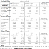
Comparison of percent of Roman Catholics and percent of Poles by county (except for Kamin-Kashyrskyi) in census of 1931:

Religions in 1931 in this area from map above, now part of Belarus and Lithuania (except for Kamin-Kashyrskyi in Ukraine):

==============================
Lithuanian gerrymandering in areas with ethnic Polish majority, since the 1990s:

2) "A" + "B" + "C" = majority ethnic Polish territory before 1921:
And this map is actually based on Lithuanian sources, so the real extent of Polish area before 1921 could be even greater:
Comparison of percent of Roman Catholics and percent of Poles by county (except for Kamin-Kashyrskyi) in census of 1931:
Religions in 1931 in this area from map above, now part of Belarus and Lithuania (except for Kamin-Kashyrskyi in Ukraine):
==============================
Lithuanian gerrymandering in areas with ethnic Polish majority, since the 1990s: