A more Aesthetically Pleasing Earth

Kal-el

Deity
Joined
Nov 6, 2001
Messages
4,827
Location
Washington DC
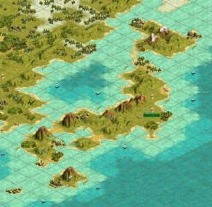
What I have done is taken Marla's map version1.13 and tweaked it a bit. My goal was to make the the continents actually look like what they are meant to represent. Don't get me wrong, Marla, you have done a great job. I in no way mean any offense. If it weren't for your work mine would not exist. I think this was the most accurate map to date. There were just a few areas that I felt could use a few more details. To this end I have interchanged plains and grassland rather freely. Too freely for some. ;) I didn't like looking at a bunch of squares that were supposed to be Italy, I wanted something that actually looked like Italy. I think I have accomplished that. I hope you like.

I have posted this in a couple of threads earlier (Realistic Starting Nations Scenario) and (Final Earth Map). After receiving some advice from Paul Saunders I made some modifications and I figure I should give this its own thread.

Changes:
Namely I adjusted the British Isles, made them smaller, lengthened France, reworked Greece, reworked the Black Sea, lengthened Israel, reworked Northern Africa, reworked the Arabian Peninsula, Reworked the Great lakes Region of the U.S., and reworked Japan.

Paul, I can't believe I totally left out the Pyrenees. Thanks for spotting that.

I look forward to hearing what you think of the map. Any comments, suggestions, critiques, are welcome.

Changes in Version 1.25
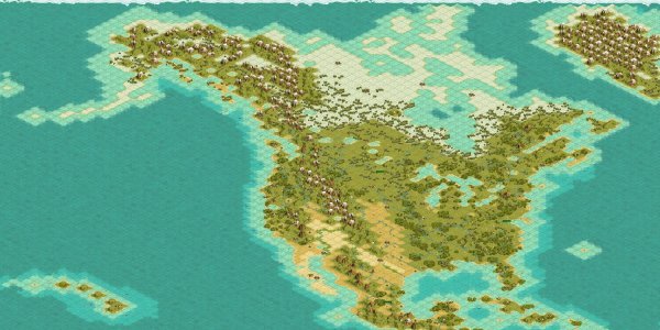
I have done a complete overhaul of North America, including Greenland.
Eastern Asia has also received some serious work.
Touched up the Iberian peninsula.
Changed the starting locations for Iroquoise - North Dakota
Changed the starting locations for Chinese - moved south to present day Canton - Gives the japanese a chance to move to Korea
Changed the starting locations for Zulu - moved them Further north.

Changes to version 1.35
compatible with patch 1.21f - now includes all original resources. there was an error when converting to version 1.3. this has been fixed.
slightly modified the Eastern Seaboard of North America
Tweaked the Iberian peninsula


You can download the file here: The file includes a map file and a civbreed file. The civbreed file is to be used with Vonatar's placement program. (I don't know if Vonatar's program only recognizes map113.c3b or not so I just named the c3b for this map that.)

Version 1.2 removed after 678 downloads
version 1.25 removed after 879 downloads
Version 1.3 removed after 142 downloads
 

Attachments

  • kal-els world map v. 1.35.zip
    49.9 KB · Views: 1,890
Here is Japan:
 

Attachments

  • japanese islands.jpg
    japanese islands.jpg
    66.4 KB · Views: 8,921
I would love to hear any thoughts on what needs to be improved. I am planning on working on North America, but I don't know when I will get around to it, what with the holidays and everything.

Merry Christmas everybody!!:santa:
 
Great! I was going to spend some time trying to modify marla's map myself in the same manner, but you've already gone ahead and done the job. Can't wait to try it out.

PS. You REALLY ought to change the name of that zip file.
 
Finally someone has responded. :) I am glad you like the map. Did you look at the pics? Did that help?

I have done some additional work to North America and Eastern Asia. I haven't posted it yet because I have only been working on it incrementally. I will probably post what I have in a few days. I am hoping to be able to do some more work on it this weekend. I think the map is pretty much done. Or at least as done as I am going to get it, but I want to put a pic together of the new changes to North America.

You don’t like the name? What’s wrong with it?

Soufie, let me know what you think.
 
Now if only someone could get this map to not take 5 mins between turns ...
 
I guess that's a prompt for a large 180x180 map of of the world to be made. There is little demand for standard world maps, and huge/giga just take too long between turns. I'll start working on it straight away.
 
The problem with 180x180 is that you lose a lot of the detail. I was thinking about doing a map that was around 220x220, hoping this would create a happy medium, but after expending so much time on this last one and working on a mod combining what I perceive to be the best aspects of all the different mods on this board and apolyton, along with various suggestions that and ideas that have only been mentioned but not posted as mods, I just don't have it in me right now to work on it. I want to eventually play a whole game!!!:D
 
:eek: Spain got a nose job!

The Iberian peninsula really ought to have 2-3 tiles added to the west coast. Portugal has fallen into the sea!

The other screenshots look great, particularly Japan. I will download it as soon as I get home...
 
Yeah, Actually I have updated that since I put the pic up on the site. I have added another Mountain to the western tip and blended that in I have also done a few other minor tweaks to western france and the riviera.

My computer at home is totally messed up right now, but I hope to have it back up and running tonight. So I can get the modified version of the map up by Monday, hopefully with some more pics.
 
:cooool:

This is one cool map!!!! I downloaded it this afternoon as I was listening to Cher's 1987 comeback album, enititled simply, "CHER". You may remember it had the hits "I Found Someone" and "We All Sleep Alone". Anyway, I'm getting off subject again. My roommate Harry says I do that a lot but he's not really a Cher fan anyway. As a matter of fact I can only play my Cher tapes when he's working down at the garage. Thank God for overtime!!!! So I downloaded it and played a game and I was blown away, I must say!!! With this map I was able to recreate the Baltic wars of the early thirties in detail and with stunning accuracy. My only suggestion would be if you could find a way to rename the barbarian tribes so they could be gypsies, tramps, or thieves. That would rock!!!! Anyway, thanks for a great map!!! You rock!!!
 
:o
 
Florida should be covered with forest and the west coat should have more mountains. And what about the Florida Keys? They are stradegically important. Also you should add one or two more tiles onto Canada. It wouldn't hurt to make the Great plains bigger either. I would do it myself except i would screw the whole map up with my luck.:( Anyways, Good map.
 
Greenland shouldn't be full of mountains. It should be almost only tundra, with a few grassland, pretty much where u put them already (and some mountains)
Iceland is too big and a bit too southern, and sweden should be a little less tundra, and more plain/forest. At the west cost of norway, there should be some grassland tiles, and britain should be made a square or so wider. hmm, Denmark needs a tile that should mirror "Sealand" or "Sjælland" (in Danish) (the island where our capital is).
You missed the faeroe islands (west of norway), not big but important. They should only be one tile - with oil though.
(Hmm, don't know if you have actually made them, but they should be futher north i think - and not with only horses, also oil)
Europe (exept scandinavia) is generally too small, it should be bigger.

But anyway, very nice job....
 
Astral,

Greenland: I realize that it should be mostly tundra but I put in the mountains to prevent the AI from going crazy and plopping settlements all over it. It seems to see all that space and just feel the urge to build. There has been some discussion about changing the food value of tundra to zero in an attempt to reduce this AI sprawl, this may work, don't know.

Iceland: I kinda felt the same way. I guess I just didn't get around to changing it.

Denmark: The problem as you noted is that the whole of Europe is confined to a small part of the map. Amazing but true, Europe is a relatively small geographical region. I am looking at my map and a map of your region and I just don't think Sealand can fit in there without making it look lumpy. The whole point of redoing Marla's map was to make it not look lumpy. Hope that doesn't offend.

Europe: The problem with making Europe larger, among other things, is that if I add tiles there I have to take them away from somewhere else, namely Africa. If you look at the minimap Europe already looks disproportionatley large. To make it larger would IMO destroy the map. There is another map originally posted by Satya and later developed by others, that does away with any pretense of scale altogether in an attempt to recreate the actual history of the Earth. To that end Europe is much larger than Africa, North America is larger than it should be with a corresponding diminishment of South America. I haven't looked at that one in a while so I don't know all the changes that have gone on there. It has received quite a lot of work and much positive feedback. Check it out if you haven't.


EQandcivfanatic,

Florida: It pretty much is covered in forest. granted there are a few tiles empty but that can easily be remedied. Actually the whole map could probably use a few more forest and jungle squares to simulate the preindustrial state of things.


West Coast: The problem with putting more mountains in the west coast is it prevents growth of big cities, like LA, San Francisco and Seattle. Maybe a few more could be put in to represent the Sierras.

Plains: Maybe By pushing the Rockies west a tile or two and pushing the plains north a tile or two. What do you think?

Canada: Here I must admit I was going more for gameplay. I cut out a few tiles that would have been tundra in order to make the livable area in North America bigger. I am a homer. Living in the U.S. has given me a bias towards her. To be perfectly frank, I am still not happy with the way North America turned out. The East Coast needs some serious work.

Kitten,

I would appreciate any efforts you make to redistributing the resources. This was not my focus.

Anyway, my next project is a 220 x 220 map. Not sure when that will get finished. I am in my third year of law school and classes are back in session. Got to find a job for afters.
 
I found another problem while playing this. There ought to be a civ in South America. Every time I've played it the AI that starts in Mexico quickly expands to S America. By the Industrial age that civ almost always has complete control over it. This civ almost always wins the game.
 
Top Bottom