question about city files

Hope when you master this you will write a tutorial on how to do it. I would like to know how to make the City Graphics, then I could make a quality looking Mexica ( Aztec ) City.

So far all the help I got was, "Cut and Paste"... :confused:


# PS: oh i nearly forgot. Columns go "Up and Down", Rows go from "Side to Side". So you were correct it is 3 Columns and 4 Rows.
 
Removed.

I realize I made a mistake on something... so I fixed it.
 
Using my modified template...

When you are finished editing the file and putting all your cities in the squares, etc., do you change the blue and green colors to magenta at the end. Or just change the blue? Or do you leave it as is? I'm not sure what colors to set 254 and 255 in the palette.

Thanks...
 
Grey Wolf... You can change all to Magenta then place Green (0, 255, 0) and Magenta (255, 0 255) for the Transparent Slots #254 and #255. You can color the Background as you like with Two Colors IF you set both colors as the Transparent Colors. The main reason Magenta and Green are used is because those pure colors are generally not used in images. (take a look at the Original Game Files)
If the colors set for the transparency slots are in the images, those parts of the images will be transparent.

Note that the palette is a 256 color palette but because it starts at 0 you see slot 255 and 256 as 254 and 255. The thing to note is that it is the last two color slots that are set as the Transparent slots on the palette.

The Transparent Slots (254, 255) can use any Colors you prefer and best if those colors are Not used in the images.

The palette uses indexes so what ever colors you set in slots 254 and 255 will be the transparent colors.
 
Grey Wolf... You can change all to Magenta then place Green (0, 255, 0) and Magenta (255, 0 255) for the Transparent Slots #254 and #255. You can color the Background as you like with Two Colors IF you set both colors as the Transparent Colors.

Thanks Vuldacon.

This city template had 2 colors so I wasn't sure what to do. I'm going to use Magenta and Green on 254 and 255 then.
That's what I do for other .pcx files. :cool:
 
Grey Wolf... yes, it is all the same. A template is used for alignment only and has nothing to do with what the game uses as far as colors.
You could just color the entire background one color such as Magenta.

The only reason to use Two colors would be to keep some sort of alignment with the files for later use but that is not necessary.

The Background being Transparent is the only thing necessary...One or Two colors and the reason for no more than two colors in the background is because the palettes can only have Two :)
 
When you are finished editing the file and putting all your cities in the squares, etc., do you change the blue and green colors to magenta at the end. Or just change the blue? Or do you leave it as is? I'm not sure what colors to set 254 and 255 in the palette.

Well, the blue with red diamond guide is a separate layer that I make invisible before flattening the image and indexing. My city template has 25 total layers - one for each rectangle, one for each city, and one for the guide. It's alot easier to manipulate each city (e.g. centering, adding buildings, etc.) that way.

Personally, I would keep the magenta and green colors otherwise if you make the background all magenta you kind of lose the placement of the city if you want to make placement adjustments later (I guess if you saved a copy this wouldn't necessarily be a problem, but I like having the guides there.). With both colors you'd need magenta in slot 0 (255) and green in slot 1 (254) or vice-versa. Without the green you could just make both those slots magenta if you wanted - doesn't really matter.

I also got to thinking about you wanting to have the walled and unwalled cities in the same position. Are you going to extend that to size 2 & 3 cities as well since many sets have the same buildings in each size just more of them?

What I did with one of Kyriakos' huge cities was scale it down to 94% first.

I seem to remember Kyriakos not being too keen on changes to his graphics, but this might not matter since it's just a small size reduction. If he doesn't mind, I'd love to reduce some as well because some of his best cities are the really large ones.
 
I would keep the magenta and green colors otherwise if you make the background all magenta you kind of lose the placement of the city if you want to make placement adjustments later (I guess if you saved a copy this wouldn't necessarily be a problem, but I like having the guides there.).

I save copies of everything, especially templates and transparent images that I've been working on, so it'd be easy for me to blank something out and paste something new back in. I think I'd rather do that than use 25 layers...

So I may use your blue zoned template every now and then to center stuff but I'd make all of the background magenta on my final save...

With both colors you'd need magenta in slot 0 (255) and green in slot 1 (254) or vice-versa. Without the green you could just make both those slots magenta if you wanted - doesn't really matter.

Right, I don't know why I got so confused over this. It's basically the same as other .pcx files where you place 2 unused colors in the palette at 254 and 255.

I also got to thinking about you wanting to have the walled and unwalled cities in the same position. Are you going to extend that to size 2 & 3 cities as well since many sets have the same buildings in each size just more of them?

No, most of the time, I like to see the size 2 & size 3 cities look more unique and it's ok if they don't match the same position. But I understand GIMP enough now where if I had to put those in the same positions, I could do so...because I could just copy the city size 1 square (the whole square) and make it transparent... Then add whatever I want to it ... and then paste it into the the size 2 slot. That way the original stuff would remain in the exact same position as it is in city size 1.

I seem to remember Kyriakos not being too keen on changes to his graphics, but this might not matter since it's just a small size reduction. If he doesn't mind, I'd love to reduce some as well because some of his best cities are the really large ones.

I decided to go with a different Asian city file so I'm not using Kyriakos' city now. But if I want to use one of his in the future,
I'll be sure to ask him before I reduce or modify one of his files...
 
I'm going to test out some of my new graphic city files today. I made a native american indian one. I'm curious to find out where the warriors stand inside the city. Because on one of cities, I put a campfire with flames and a little smoke. And I wouldn't want my warrior to be standing on top of the fire! :lol:
 
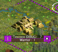
I'm also curious to know what happens when roads get built. I don't want the roads to overlap any part of my city. I sprawled little tee-pees all over the top of the size 3 city and I'm not sure what things will look like when roads get built.

So a lot of testing today.

Also, I'm trying to decide what the default rAmer.pcx file should look like for ancient and medieval times. Right now,
I think the default should be native american images (tee-pees, etc). That would cover North America.
South America needs Aztec temples and things like that. But we only have 1 culture file to handle it, which sucks.
And I decided that I don't want to see meso-american type buildings in "Washington" for America. It makes no sense.
But I can suspend belief enough to imagine the Inca or Aztecs living in Tee-pees. Or the "ancient" Americans living
in tee-pees...

Also, I don't want to show those big temples in a city because when the game plays, it'll show them in every city ... even if you didn't build a temple there yet or anything... which makes no sense.

Oh hell, none of this stuff makes any sense! But it's fun. :)

I meant to say I'm making some alternative rAmer.pcx files that I can swap in/out of the game depending
on which civilizations I want to play...

Too much information! Stop Gray Wolf. Stop! :)
 
I save copies of everything, especially templates and transparent images that I've been working on, so it'd be easy for me to blank something out and paste something new back in. I think I'd rather do that than use 25 layers...

So I may use your blue zoned template every now and then to center stuff but I'd make all of the background magenta on my final save...

I should have said the template itself has only 13 layers, but when you paste a city into the file a new layer is automatically created so you end up with 25. Out of curiosity, what program do you use? It seems like it'd be a huge headache to manipulate graphics on only a single layer.

I've only used that guide to check for terrain overlapping, my cities are automatically centered when I paste them in, but it's good you can use it for that if necessary. Sounds like you have an interesting project going - looking forward to seeing some screenshots of how your cities look in-game.
 
Gray Wolf. Only a few Plains Indians lived in Teepees. And usually when Hunting Migrating Bison. Most American Peoples lived in Large Structured Groups. Many Tribes had Pyramid Set ups similar as in Central America. Unfortunately most of the unique Cultures of Native America Indians were "Liquidated", so we know little of them.

The problem with this 5 Culture Groups is a major problem. How to get a balance between the different nations of 1 continent is hard. How can Europe have just one look? ---- I have no worries with 'America' race in civ. It is just the US so I just delete it. Is not a culture, but a modern country. So when doing an American City Graphic I guess US will be the Last Modern Images.

When building Pyramids certain Cultures had unique Pyramid setups. Maya have as their main Pyramid as a 9 level Pyramid. This represents the 9 levels of Heaven and 9 levels of the Underworld.

Mexica (Aztec) have their Pyramids with only 4 levels. This represents the previous 4 Suns. ( The previous 4 periods of man ). The alter(s) at the top is/are this current Sun. Our time on Earth now. The sacrifices of beating hearts in these alters were to keep this Sun alive.

Ironically the Tribes of Peru and Bolivia also have the same thinking of 4 periods on Earth. I suspect the Tarascan Nation and many other northern tribes may also follow this thinking. I have seen some pyramids from Southern States that show 4 levels.

Thanks MPK. I did not know that about tee-pee's. I'm making alternative files and I was going to use the native american tee-pee as the default one ... but I'll probably make the meso-american one the default instead, because it covers North America better than I thought. And it would definitely cover South America...
 
I am sure someone will tell you the opposite about how many Tribes used the Teepee. They are made of Buffalo Hide. No Buffalo in Florida or near the Great lakes. :lol:
 
It is only the semi-nomadic tribes in the Great Plains (USA & Canada) that traditionally used tipis. There are a few other movable shelter styles, but as was suggested, the majority of indigenous people in North America had some type of permanent settlements. and Mound/Pyramid structures were widely used.

You might want to look at RedAlert's Mississipian (preview in next post) and Mesoamerican cities for inspiration / comparison. Places like Cahokia and Copan were of a respectable size by modern population standards, especially if you look at population density rather than absolute numbers.
 
I have a strange thing happening. I have a scenario and when I play it with the Aztecs as a debug, the Aztecs build a size 2 city as their first city... I'm using the rAmer.pcx file that came with the game.

Here's a screen shot of the first city that the Aztecs built.
It's definitely an ancient size 2 city, the one in the second column of the rAmer.pcx file.

Spoiler :


Does anyone know what could cause this? I need them to build a size 1 city first.
I looked in the .biq file for my scenario and I can't find any settings related to this. All the general settings seem to be the same as the default .biq file.

Anyway, if someone can point me in the right direction, I'd appreciate it. I have no idea why it would build a size 2 city at the beginning of the game...

Thanks.
 
It is only the semi-nomadic tribes in the Great Plains (USA & Canada) that traditionally used tipis. There are a few other movable shelter styles, but as was suggested, the majority of indigenous people in North America had some type of permanent settlements. and Mound/Pyramid structures were widely used.

You might want to look at RedAlert's Mississipian (preview in next post) and Mesoamerican cities for inspiration / comparison. Places like Cahokia and Copan were of a respectable size by modern population standards, especially if you look at population density rather than absolute numbers.

I did not know that. I thought all indians used Tipi's. Learn something every day!

I really like Red Alert's Mississipian city file and Pounder's Mesoamerican file. I'm not sure which one I like best but I may use one of them in my mod (instead of making my own) because they are both pretty good.

I also read about the Cahokia and the Monks Mounds. Very interesting.
 
I really like Red Alert's Mississipian city file and Pounder's Mesoamerican file. I'm not sure which one I like best but I may use one of them in my mod (instead of making my own) because they are both pretty good.
Maybe use them both for a multi-era set?
 
The Capital always starts as a size 2 city graphic...or, rather the city with the Palace (It's hardcoded that way).

Thank you. I never noticed that before until I started building city files and testing them. That makes sense now.
 
Top Bottom