Map Advice For WW0 (7 Years War Global) - 2

Ozymandias

In Terra Fantasia
Supporter
Joined
Nov 5, 2001
Messages
10,829
Location
The lone and level sands
Greetings Again,

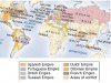
I've been playing around with a global map identifying the major theaters of operation of the 7 Years War worldwide ("World War Zero.")

I've arrived at the attached for the moment ...

Again, my goals are (1) no global circumnavigation and (2) inclusion of any possibly significant theaters of operations, especially with the Chinese in the roster of Civs.

My question regards point #2: Does anyone see a way that the major theaters of operations (again, now including China) can be relatively enlarged, such as Yoda Power did with Europe in his 256 x 256 global map?


Thanks Once Again To All,

Oz


PS - BTW, is it my imagination, or are we lacking global maps which (1) actually demonstrates how much further south South America extends than Africa and (2) how far east South America actually is in relation to North America?

-O.
 

Attachments

  • Experimental 7YW Map - CFC Post.jpg
    Experimental 7YW Map - CFC Post.jpg
    64.2 KB · Views: 109
My question regards point #2: Does anyone see a way that the major theaters of operations (again, now including China) can be relatively enlarged, such as Yoda Power did with Europe in his 256 x 256 global map?
That would probably require a completely new map. I'm sure I could do it but it would take more time than I currently has.

edit: after a second look at my Earth map I actually think it would be done by just cropping it. Europe, North America and India has a lot of space for cities already. But of course it depends on how big you want it.

PS - BTW, is it my imagination, or are we lacking global maps which (1) actually demonstrates how much further south South America extends than Africa and (2) how far east South America actually is in relation to North America?
I would claim that my earth map actually does that. :)
 
[...] edit: after a second look at my Earth map I actually think it would be done by just cropping it. Europe, North America and India has a lot of space for cities already. But of course it depends on how big you want it.

It's not so much space for cities (I'm debating if they'll even be Settlers in a game covering ~7 - 10 years) as room for maneuver which, from what I've gathered, was crucial to Frederick the Great's victories. (I'm considering giving Prussian infantry MF=2. Irregulars are a little known yet crucial part of the war in Europe; North America would obviously have a much lower troop density than Europe.)

I'd like to somehow keep the area scale the same in Eurasia (India & China) as Europe and North America; shrink the rest ... Perhaps compress Eurasia East-West and make the Urals very difficult to cross ...

I like an overall map size of 256 x 256 although, with the expansion in relative size of the major theaters of operation, I would consider a larger map. (Also note that the projection is rotated.) timerover1951 has already begun helping me work out movement rates, and I'll be further picking his brain and extensive knowledge base for the most important types of ships (after all, there are only so many units in the Units db) as well as combat and bombardment factors; I suppose I'll have to substitute Sea tiles for Ocean tiles in many places and reserve Ocean tiles (with greater movement cost) for the smaller scale areas of the map.

YP, you are, as ever, are a Gentleman and a Scholar for even considering offering to help. Mercifully, Blue Monkey has offered to help as well, which is wonderful on many levels: his knowledge of advanced map editing and far greater knowledge than mine of Asian militaries of the time shall indubitably be invaluable.

I would claim that my earth map actually does that. :)

:hammer2: Sometimes one can't see the forest for all the trees in the way.


Thank You Again and Best Regards,

Oz
 
So, re: my stated goals, this is a rough approximation (I just keep c&p-ing the same map so that its "evolution" can be tracked, even though names are truncated and whatnot.)

Aesthetically, I think it does make our lovely globe look a tab grotesque ... But I think it could, by and large work (and, yes, I'd probably need to do it from scratch, but so it goes.)

Light blue would be "Sea" tiles, dark blue "Ocean" tiles, the principal difference being MF to take into account differing distances (equivalently compressed land areas would be largely dealt with by impenetrable terrain such as Jungle.)

Should China be larger? Korea included? --

Thoughts? Critiques? Suggestions? Death threats? :mischief:


:xmascheers: ,

Oz
 

Attachments

  • Experimental 7YW Map -2 - wk1a.jpg
    Experimental 7YW Map -2 - wk1a.jpg
    44.8 KB · Views: 101
"Size" involves what sort of play you are looking for. How many civs are going to be in India at the start, for example. If a civ has room to expand without interference the more map space you give it the more powerful it will be. Obviously. But that is an important consideration.

Biq maps are already grotesque. either the minimap is pretty and the main map is distorted, or it's the other way round. We're creating field of battle where each faction has a more or less equal shot at victory. That's way different than cartography.

Since South Asia is about the only part I'm familiar with these are the questions I see: how strong are you going to make the French at the beginning? Are you going to have more than one Indian faction? How strong will you make the Dutch in Insulindia? <just learned that geopolitical term>

If you haven't played Rise and Fall of the Mughals lately, do so. It will give a pretty good idea of the balance of forces during the Carnatic Wars (the Indian part of the Seven Years War).

In addition to the maps a flexible list of the 31 civs involved would help focus our specific comments.
 
"Size" involves what sort of play you are looking for. How many civs are going to be in India at the start, for example. If a civ has room to expand without interference the more map space you give it the more powerful it will be. Obviously. But that is an important consideration.

Again, given the 7 ~ 10 year span of the game, I'm thinking of doing without Settlers altogether. I want enough space to simulate the constraints of military maneuvers in all three major theaters.

Biq maps are already grotesque. either the minimap is pretty and the main map is distorted, or it's the other way round. We're creating field of battle where each faction has a more or less equal shot at victory. That's way different than cartography.

:whew:

Since South Asia is about the only part I'm familiar with these are the questions I see: how strong are you going to make the French at the beginning? Are you going to have more than one Indian faction? How strong will you make the Dutch in Insulindia? <just learned that geopolitical term>

In general, I'd like as accurate an OOB as possible and (hint, hint, to those willing to help who are knowledgeable about, oh, say, the Qing military) OOB as possible for all parties concerned - especially interesting viz. the French, as balancing their forces to best suit their perceived needs essentially cost them North America.

And I really like the (new for me as well) term, "Insulindia." :cool:

If you haven't played Rise and Fall of the Mughals lately, do so. It will give a pretty good idea of the balance of forces during the Carnatic Wars (the Indian part of the Seven Years War).

Excellent, and a big Thank You to you and the creators.

In addition to the maps a flexible list of the 31 civs involved would help focus our specific comments.

As usual, the (up to) 31 most important ones :D I really need to decide if I wish to have an AoI-esque trade system, which might help weigh factors.

Civ list to follow in a few days.

- One last: any recommendations as to whether I should try to C&P the map using available tools or just go for the (obviously laborious) task of creating a new map (BTW, I was debating something as "simple" as beginning by C&P-ing areas from a 362x362 map into a 256x256 frame and seeing how that scale works out.)


:thanx: & :worship: ,

Oz
 
One last: any recommendations as to whether I should try to C&P the map using available tools or just go for the (obviously laborious) task of creating a new map (BTW, I was debating something as "simple" as beginning by C&P-ing areas from a 362x362 map into a 256x256 frame and seeing how that scale works out.)

I'd recommend ...
  1. Start with a decent image such as a sat photo.
  2. Distort & CnP it as was done w/ the maps earlier in the thread
  3. Use that image as the input for Quintillus' editor.
  4. Hey Presto!
In a situation like this it will be fairly straightforward to go back to step 2 & rework sizes and relationships as needed until you've got something workable enough to stick with the biq for further refinement.

2 more weeks of slog then the semester will be over & I can get back to doing some c3 work. :coffee:

Excellent :thumbsup:

Steps 1&2 should be easy enough.

Being (once again :yup: the self-proclaimed Village Gfx Idiot) I've not used Quintillus' editor but, from what I gather, it is well documented and more than reliable.

My favorite, of course, is the, "Hey Presto!" part.

Good fortune with the slog - Derrida? Foucault? - and a happy return to the infinitely more fun-filled "world" here.


:xmascheers: * ,

:)z

* BTW, you are a mod so why do I only have ca. a 1 month window within which to use a Martini-toast smilie :groucho:
 
Being (once again :yup: the self-proclaimed Village Gfx Idiot) I've not used Quintillus' editor but, from what I gather, it is well documented and more than reliable.
To be honest I haven't used it for much besides map-making. It is reliable - and far easier to use than map tweaker. For one thing the palette is not as limited. More colors to choose from & you get to choose what terrain they represent. Plus, he's worked out some functionality for the unavailable (in the standard editor) landmark terrains. could make it easier to make some more parts of the map unsettlable or impassible. Since graphics can make just about any terrain mimic the look of another ...

Good fortune with the slog - Derrida? Foucault? - and a happy return to the infinitely more fun-filled "world" here.
The slog is more a matter of getting slammed with term projects at the same time that weren't posted earlier in the semester.

The best part of the semester (semiotically speaking) was reading some Saussure & Barthes in the context of a linguistic anthropology class. Brilliant professor - just got her doctorate. So she still thinks people are going to college to learn. We're setting up an independent study for next term. Apparently "worlding" is a current buzz word in anthropological academia. So I'm going to look in to modelling (as in Unity + Blender + GIMP) cosmogonies. Or something equally demiurgic & potentially proposable.

* BTW, you are a mod so why do I only have ca. a 1 month window within which to use a Martini-toast smilie :groucho:
Check out the empty space above my avatar. Guess you're one of the few who haven't noticed that I've been off the reservation for quite a while. I keep having to remind myself that I may no longer be a goat

but I don't live under a bridge.


The solution to the smiley problem is simple. DL the gif then stash it away somewhere - like at a free graphics upload service. Then use the good old "insert image" button any time you like.
 
To be honest I haven't used it for much besides map-making [...]


Fair enough. :)

So she still thinks people are going to college to learn.

:rotfl:

We're setting up an independent study for next term.

:thumbsup:

[...] "worlding" [...]


"You won&#8217;t find the term Worlding in any dictionary, even though the term has been in use for nearly a century. Martin Heidegger popularized the neologism in his 1927 Being and Time to mean &#8220;being-in-the-world.&#8221; The idea was to use a verb signifying something ongoing and generative, which could not be reduced to either a philosophical state or a scientific materiality. Since then &#8220;worlding&#8221; has appeared dozens of times in philosophy, politics, cultural studies, and technology studies. The word has been appropriated, contested, but never quite pinned down&#8211;&#8211;and so remains a floating signifier. Linguists have taught us that terms like &#8220;worlding&#8221; work less as fixed essences than as mediators of differences among the utterances and concepts around them. But this undetermined character hardly makes &#8220;worlding&#8221; innocent, deriving as it does from a noun referencing concepts of origins, boundaries, ethnicities, governance, and even consciousness itself."
- http://worlding.org/what-in-the-world-2/

"Floating signifier" WTF?? Goddamned post-modern semioticians :gripe: (Sorry, I've been spending too much time on Quora (q.v.) ;) ) (BTW, I'm on a personal, Quixotic quest to use every CFC smilie/emoticon at least once :crazyeye: )

Check out the empty space above my avatar. Guess you're one of the few who haven't noticed that I've been off the reservation for quite a while.


The solution to the smiley problem is simple [..]

Got it :goodjob:


As Ever, :thanx: ,

Oz


P.S. Any specific recommendations for that, "decent image such sat photo?" (But fear not, I'm certain I can find one.)


-;).
 
Thanks for the link on worlding.

Floating signifier = :dunno: "that depends ..." think about /communist/ during the 1950s.

I always look at wikicommons for a start. A decent selection of relief maps and satellite images.

You're most welcome :hatsoff: -&- Thank you :hatsoff:

:D
 
Is here the best place to post to you regarding the naval and land stuff for your mod? And where do you want the Spanish-American War and later stuff? By the way, I am also pretty good on the Russo-Japanese War, and World War 1 as well. The land part, except for Lettow-Vorbeck in Africa and the Middle East campaigns, drives me nuts, but the naval side is marvelous.
 
Is here the best place to post to you regarding the naval and land stuff for your mod? And where do you want the Spanish-American War and later stuff? By the way, I am also pretty good on the Russo-Japanese War, and World War 1 as well. The land part, except for Lettow-Vorbeck in Africa and the Middle East campaigns, drives me nuts, but the naval side is marvelous.

I'll start a new thread in a few weeks (R/L has been bonkers for awhile.)

After 12+ years at CFC ( :eek: ) I finally really, really want to get a few mods out; I think I'll put all my IT & Wall Street skills to work and actually do them, with some rigor, in order ... :crazyeye: ...

  • 1701 ~ 1770 Worldwide
  • WW1 1898 (FINALLY all those wondrous airships tom2050 made at my request will see action! :D )

I imagine it'd make the most sense to add info as the threads evolve.

Q: Is it the trench warfare aspects of WW1 which vex you?

- And I must conclude, once again, with You, Sir, Are Ever A Gentleman And A Scholar.


:goodjob: ,

Oz

Greetings, Oz. As I assume that you are going to have a fair number of pre-placed units, do you want me to start some lists of ship names for you of the various nations? I have more data on some countries than others for the 1700s, but with 1898 to WW1, I am rock solid. I can give you leaders too, for the most part, if you are using pre-placed leaders as well.

My Spanish-American war reference library is increasing by leaps and bounds, and I am seriously considering getting a copy of the US Army Cook Book for 1896. I have the ones for 1883, 1910, and 1916 in hard copy.

Also, based on the reports of Richard Harding Davis, an extremely good American war correspondent, who was in Cuba prior to the start of the Spanish-American War, the Spanish soldiers were quite good material, their officers were a different story. The Navy personnel was good, their ships, again a different story. Cuba was a massive money drain for the Spanish government, with the money going to the Army (and assorted unscrupulous individuals, so Corruption rampant), and not the Navy. I am not sure how you would reflect that in the game though.
 
Top Bottom