Jean Elcard
The Flavournator
Culturally Linked Starts v 1.1.3
Description: "Culturally Linked Starts" reassigns the starting locations generated by a map script of your choice in a way, that they somehow ressemble the distribution of the real civilisations and the distances between them on earth. London should be near Paris but far away from Kyoto for example. You might remember a similar functionality from Civilization![[civ3]](/images/smilies/civ3.gif "Civ3 Icon [civ3]") . You are allowed to use up to 40 civilisations. See the first screen shot below for a map with 34 civilisations reassigned solely by the Culturally Linked Starts mod.
. You are allowed to use up to 40 civilisations. See the first screen shot below for a map with 34 civilisations reassigned solely by the Culturally Linked Starts mod.
Downloads: There are two versions available. The first is Culturally Linked Starts only and the second is a merge of Culturally Linked Starts with Better BTS AI. Both versions come with an Installer/Uninstaller and the repective source code.
Culturally Linked Starts 1.1.3 for BtS 3.19 06/11/2009
Culturally Linked Starts 1.1.3 for BtS 3.19 + Better BTS AI 0.78 06/29/2009
There are also some mod packs coming with Culturally Linked Starts as one of their components. The ones I know of are:
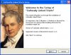
Usage: I made "Culturally Linked Starts" a game option. You'll find it at the end of the options list on the Custom Game page. See the second screen shot below, it should help you find the option. Culturallly Linked Starts is not active in non-custom games. Be also aware, that the linking is a very hard to solve optimization problem and that your computer will need some time to find a nice solution. You won't recognize a big impact on map init time with let's say 20 nations, but with 34 civilization it takes up to 3 minutes on my machine (2500 Mhz).
Credits: Thanks to the Better BTS AI Team for making the great mod I merged CLS with.
Note to Modders: If you want to use FlavourMod as a mod component for a mod with more or other than the default BtS nations you'll have to add their geographical location to the real world coordinates list in the file CvCultureLinkInterface.py. It's very easy to do and should be rather self-explaining. The current list looks like shown in the spoiler below. You can get the decimal coorrdinates for almost every important or not important point on earth from the Wikipedia, Google Maps or whatever.
Description: "Culturally Linked Starts" reassigns the starting locations generated by a map script of your choice in a way, that they somehow ressemble the distribution of the real civilisations and the distances between them on earth. London should be near Paris but far away from Kyoto for example. You might remember a similar functionality from Civilization
. You are allowed to use up to 40 civilisations. See the first screen shot below for a map with 34 civilisations reassigned solely by the Culturally Linked Starts mod. Downloads: There are two versions available. The first is Culturally Linked Starts only and the second is a merge of Culturally Linked Starts with Better BTS AI. Both versions come with an Installer/Uninstaller and the repective source code.
Culturally Linked Starts 1.1.3 for BtS 3.19 06/11/2009
Culturally Linked Starts 1.1.3 for BtS 3.19 + Better BTS AI 0.78 06/29/2009
There are also some mod packs coming with Culturally Linked Starts as one of their components. The ones I know of are:
- Ninja2's Merged Mod (since v0.83)
- Grave's History in the Making (since v2.00)
- Thomas SG's Community Civ V (since v3.00 alpha 6)
- PieceOfMind's Probably Improved Gameplay Mod (since v0.6)
Usage: I made "Culturally Linked Starts" a game option. You'll find it at the end of the options list on the Custom Game page. See the second screen shot below, it should help you find the option. Culturallly Linked Starts is not active in non-custom games. Be also aware, that the linking is a very hard to solve optimization problem and that your computer will need some time to find a nice solution. You won't recognize a big impact on map init time with let's say 20 nations, but with 34 civilization it takes up to 3 minutes on my machine (2500 Mhz).
Credits: Thanks to the Better BTS AI Team for making the great mod I merged CLS with.
Note to Modders: If you want to use FlavourMod as a mod component for a mod with more or other than the default BtS nations you'll have to add their geographical location to the real world coordinates list in the file CvCultureLinkInterface.py. It's very easy to do and should be rather self-explaining. The current list looks like shown in the spoiler below. You can get the decimal coorrdinates for almost every important or not important point on earth from the Wikipedia, Google Maps or whatever.
Spoiler :
Code:
	coords.append(GeographicalCoordinate("CIVILIZATION_AMERICA", 38.895, -77.037))
	coords.append(GeographicalCoordinate("CIVILIZATION_ARABIA", 21.423, 39.826))
	coords.append(GeographicalCoordinate("CIVILIZATION_AZTEC", 19.419, -99.146))
	coords.append(GeographicalCoordinate("CIVILIZATION_BABYLON", 32.536, 44.421))
	coords.append(GeographicalCoordinate("CIVILIZATION_BYZANTIUM", 41.009, 28.976))
	coords.append(GeographicalCoordinate("CIVILIZATION_CARTHAGE", 36.887, 10.315))
	coords.append(GeographicalCoordinate("CIVILIZATION_CELT", 46.923, 4.038))
	coords.append(GeographicalCoordinate("CIVILIZATION_CHINA", 39.929, 116.388))
	coords.append(GeographicalCoordinate("CIVILIZATION_EGYPT", 25.721, 32.610))
	coords.append(GeographicalCoordinate("CIVILIZATION_ENGLAND", 51.508, -0.128))
	coords.append(GeographicalCoordinate("CIVILIZATION_ETHIOPIA", 14.117, 38.733))
	coords.append(GeographicalCoordinate("CIVILIZATION_FRANCE", 48.867, 2.333))
	coords.append(GeographicalCoordinate("CIVILIZATION_GERMANY", 52.517, 13.417))
	coords.append(GeographicalCoordinate("CIVILIZATION_GREECE", 37.967, 23.717))
	coords.append(GeographicalCoordinate("CIVILIZATION_HOLY_ROMAN", 50.775, 6.084))
	coords.append(GeographicalCoordinate("CIVILIZATION_INCA", -13.508, -71.972))
	coords.append(GeographicalCoordinate("CIVILIZATION_INDIA", 28.667, 77.217))
	coords.append(GeographicalCoordinate("CIVILIZATION_JAPAN", 35.017, 135.767))
	coords.append(GeographicalCoordinate("CIVILIZATION_KHMER", 13.424, 103.856))
	coords.append(GeographicalCoordinate("CIVILIZATION_KOREA", 37.566, 126.978))
	coords.append(GeographicalCoordinate("CIVILIZATION_MALI", 16.773, -3.007))
	coords.append(GeographicalCoordinate("CIVILIZATION_MAYA", 17.222, -89.623))
	coords.append(GeographicalCoordinate("CIVILIZATION_MONGOL", 47.198, 102.821))
	coords.append(GeographicalCoordinate("CIVILIZATION_NATIVE_AMERICA", 38.659, -90.061))
	coords.append(GeographicalCoordinate("CIVILIZATION_NETHERLANDS", 52.371, 4.897))
	coords.append(GeographicalCoordinate("CIVILIZATION_OTTOMAN", 41.012, 28.976))
	coords.append(GeographicalCoordinate("CIVILIZATION_PERSIA", 29.934, 52.891))
	coords.append(GeographicalCoordinate("CIVILIZATION_PORTUGAL", 38.717, -9.167))
	coords.append(GeographicalCoordinate("CIVILIZATION_ROME", 41.883, 12.483))
	coords.append(GeographicalCoordinate("CIVILIZATION_RUSSIA", 55.752, 37.632))
	coords.append(GeographicalCoordinate("CIVILIZATION_SPAIN", 40.413, -3.704))
	coords.append(GeographicalCoordinate("CIVILIZATION_SUMERIA", 31.322, 45.636))
	coords.append(GeographicalCoordinate("CIVILIZATION_VIKING", 63.420, 10.393))
	coords.append(GeographicalCoordinate("CIVILIZATION_ZULU", -28.317, 31.417))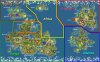

") I'll use it in personal (and probably not only there) mod
I'll use it in personal (and probably not only there) mod

")
