ww2commander
Emperor
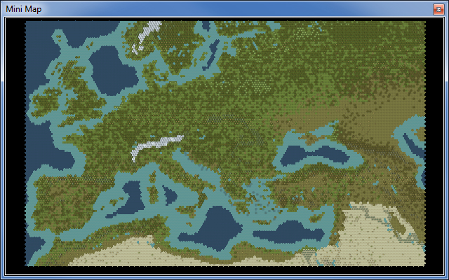
This is a 166x118 representation of Europe. This map was intended for a medieval mod so its focus is limited in scope with uppermost Europe (the really cold bits  ) removed and the minimum space used to represent Africa and the Middle East. The orientation has been rotated slightly to minimize the 'uselss' portions of Siberia not needed by my mod (sorry no Ural Mountains
  )
)
Click here to download from the CFC Database
This map has been constructed from scratch by overlaying a hex grid over an actual map so the land form is as close as possible to the real thing with the exception of the following:
Rivers
All rivers have been placed using the same hex comparison method and only deviate slightly to allow breathing room between certain cities in France, Germany and the Balkans (normally this is a 1 hex deviation).
Mountains & Hills
Mountains and hills are also placed as accurate as possible but additional plots have been added to emphasize strategic choke-points or land barriers such as the Alps, Caucasus and Carpathian mountain ranges.
I have also placed key strategic passes through mountain ranges based on the more common ones known during the middle ages. You can add/remove these passes if needed.
Forest/Swamps
As my intent was to mod the medieval era, the map has more forests than would be common today. Swamps are also placed in appropriate historical locations but to a lesser extent to avoid handicapping any player. I have also included oasis plots as close to historical locations where I could find data. Unfortunately this means that most of them are in locations less than ideal to game play!
Player/City Locations
There are no player start locations defined. You will need to do this yourself as the map was intended to be used with custom civs instead of the vanilla civs.
The map has hundreds of city locations represented by 'city ruin' icons. These serve as a guide for my needs but can be replaced with actual player cities as needed. Some city locations correspond to old medieval cities so don't pull your hair out if you are unsure as to some of them. Also, some positions are slightly shifted to give some breathing space between cities in Germany, France and Italy.
The best approach is to use the rivers as guide-points in locating the name of cities on the map. One exception is the proposed position for Medina which is ahistorically positioned at plot 144,3.
Resources
None. You will need to add these yourself. The reasoning here is that some modders might have different ideas as to how they use the map.
Some background as to why I am releasing this
The biggest problem about being a modder is finding the time and energy to see things through! I am the worst offender of this and seem to have quite a lot of finished 'bits and bobs' on my computer that never see the light of day!
This time round I thought it would be a good idea to release my custom map I have been working on for a potential medieval mod (don't ask any questions as you will be disappointed with the answers") )
)
I hope you enjoy this map as much as I enjoyed creating it.
Please feel free to let me know what you think or show off any mod creations you might have using it.
Cheers.
) removed and the minimum space used to represent Africa and the Middle East. The orientation has been rotated slightly to minimize the 'uselss' portions of Siberia not needed by my mod (sorry no Ural Mountains )Click here to download from the CFC Database
This map has been constructed from scratch by overlaying a hex grid over an actual map so the land form is as close as possible to the real thing with the exception of the following:
- Land bridges exists at key strategic points to cater for mod purposes. These plots are Europe/Anatolia (plot 107,44), Sicily/Italy (plot 71,29), Crimea/Caucasus (plot 125,62). These can be removed as needed.
- England has been widened by 1 hex on each side to allow more room for what I needed to do (represent the various Saxon kingdoms before they merged)
- The Italian peninsula has been made wider by 1 hex for similar reasons.
- Malta is represented by 3 hexes as opposed to 2 to allow some room for invading.
Rivers
All rivers have been placed using the same hex comparison method and only deviate slightly to allow breathing room between certain cities in France, Germany and the Balkans (normally this is a 1 hex deviation).
Mountains & Hills
Mountains and hills are also placed as accurate as possible but additional plots have been added to emphasize strategic choke-points or land barriers such as the Alps, Caucasus and Carpathian mountain ranges.
I have also placed key strategic passes through mountain ranges based on the more common ones known during the middle ages. You can add/remove these passes if needed.
Forest/Swamps
As my intent was to mod the medieval era, the map has more forests than would be common today. Swamps are also placed in appropriate historical locations but to a lesser extent to avoid handicapping any player. I have also included oasis plots as close to historical locations where I could find data. Unfortunately this means that most of them are in locations less than ideal to game play!
Player/City Locations
There are no player start locations defined. You will need to do this yourself as the map was intended to be used with custom civs instead of the vanilla civs.
The map has hundreds of city locations represented by 'city ruin' icons. These serve as a guide for my needs but can be replaced with actual player cities as needed. Some city locations correspond to old medieval cities so don't pull your hair out if you are unsure as to some of them. Also, some positions are slightly shifted to give some breathing space between cities in Germany, France and Italy.
The best approach is to use the rivers as guide-points in locating the name of cities on the map. One exception is the proposed position for Medina which is ahistorically positioned at plot 144,3.
Resources
None. You will need to add these yourself. The reasoning here is that some modders might have different ideas as to how they use the map.
Some background as to why I am releasing this
The biggest problem about being a modder is finding the time and energy to see things through! I am the worst offender of this and seem to have quite a lot of finished 'bits and bobs' on my computer that never see the light of day!
This time round I thought it would be a good idea to release my custom map I have been working on for a potential medieval mod (don't ask any questions as you will be disappointed with the answers
)I hope you enjoy this map as much as I enjoyed creating it.
Please feel free to let me know what you think or show off any mod creations you might have using it.
Cheers.
")
