TheLastOne36
Deity
- Joined
- Jan 17, 2007
- Messages
- 14,045
I find Kosovo very interesting in that map, among other borders...
") Either you put Dobrogea (aka Dobrudja), the eastern "tail-like" thing inside Wallachia, or you make it independent - it was never shared between Moldova and Wallachia, being first under the control of the Byzantine Empire, then briefly independent, then Wallachia, then the Ottoman Empire, then again Wallachia, and then Romania.
Either you put Dobrogea (aka Dobrudja), the eastern "tail-like" thing inside Wallachia, or you make it independent - it was never shared between Moldova and Wallachia, being first under the control of the Byzantine Empire, then briefly independent, then Wallachia, then the Ottoman Empire, then again Wallachia, and then Romania.

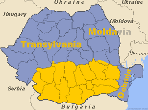
How 'bout equanimity?So either you include Dobrogea inside Wallachia, or you make it its own region. Splitting it between Moldova and Wallachia makes no sense from any point of view I can think of.
the brown part was my horribly failed attempt at making a Silesian state and the purple part is KrakowskieSince I'm here, may i ask what that brown and purple stuff in Poland are?
@Mad Man 2.0:
I guess in Romania you probably tried to divide the current border between the 3 historical principalities - in that case, the eastern part of the border between Moldova and Wallachia is rather screwed up.
Also, although not that much, the western border between Wallachia and Transylvania is also not really good - again you gave too little to Wallachia and too much to Transylvania.
Here's how the three principalities looked like (map from 1600, the date of the first unification):
Spoiler :
Here's Wallachia in 1390, under Mircea the Elder, aka Mircea cel Batran (including Dobrogea, as it was under Wallachia control at the time):
Spoiler :
And here's the territory of Wallachia-proper superimposed over today's border (without Dobrogea):
Spoiler :
So either you include Dobrogea inside Wallachia, or you make it its own region. Splitting it between Moldova and Wallachia makes no sense from any point of view I can think of.
 ,and yes I was trying to divide Romania in to it's historical principalities. So for my to do list fix Poland and Kosovos borders and make Wallachia beefier.
That's funny, Transylvania pretty much exactly lines up with the heavily Hungarian part today. Is that a coincidence?
And no, it doesn't really coincide. Hungarians are a majority only next to the border and in the "tip" of Transsylvania Well, it's not like 900+ years of Hungarian or Austro-Hungarian domination over the land would have anything to do with that.That's funny, Transylvania pretty much exactly lines up with the heavily Hungarian part today. Is that a coincidence?

I'm afraid I don't understand what you mean... Are you saying that I'm too stressed?How 'bout equanimity?
Or what?Maybe I shoulda said egalitarianism.I'm afraid I don't understand what you mean... Are you saying that I'm too stressed?
Most of the cities in CivIV on a map
Spoiler :
Portugal is the only country with colonies in the city-list.

That map proves the need for Polish-Lithuanian civ. And perhaps swedish. It'd fill the void between Russia and Germany, as Ukraine, Belarus, Lithuania, Poland, Latvia, Kaliningrad oblast and even Estonia were part of it. Moldova was a fief too.
Interesting, what are those 3 HRE cities in Poland?
Also you didn't take into factor the fact that some cities moved substantially over the period of time.
What's the Aztec city near the US-Mexico border?