mythmonster2
BEC NOIR! RUN!
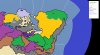
Ack, the day almost got away from me. Here's the map, with a legend beneath.

Green F: Forest. White O: Ore, with I representing iron, T representing tin, and C representing copper. Black M: Minerals. Brown P: Pastoral, with F representing the foodstuffs and R representing the riding animals. Rivers are in the northeast and northwest, in case they can't be found.
Green F: Forest. White O: Ore, with I representing iron, T representing tin, and C representing copper. Black M: Minerals. Brown P: Pastoral, with F representing the foodstuffs and R representing the riding animals. Rivers are in the northeast and northwest, in case they can't be found.