- Home
- Forums
- OUR ARCHIVES
- List of Archived Forums
- Civilization II Archives
- Civ2 - Game of Democracy III
You are using an out of date browser. It may not display this or other websites correctly.
You should upgrade or use an alternative browser.
You should upgrade or use an alternative browser.
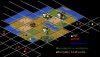
Next turn - 3900bc
- Thread starter Jayne
- Start date
- Status
- Not open for further replies.


Shahadet
Naga Guardian
I still think that a city founded on the buffalo would be the best city site to use right now. I suggest moving the settler to the NE back to the buffalo and building a settler colony there. The SE settler might as well continue exploring and move to the jungle terrain (revealing more sqaures) and the archer should continue exploring SE. Already we have two turns without scientific research, we should really be thinking about getting a city in the next turn or two. Considering that this is deity the need for early scientific research cannot be stressed enough. The opening land may not be the best but it is more the capable of supporting a medium growth city.
Could someone please post a special possibility map like DVR did?
I would, but I'm on someone elses laptop, and they have no image editing software. It would be nice to have different colored dots for different possible overlays of specials.
I'll post opinions on movement either after someone does that or after I get home.
I would, but I'm on someone elses laptop, and they have no image editing software. It would be nice to have different colored dots for different possible overlays of specials.
I'll post opinions on movement either after someone does that or after I get home.
Shahadet
Naga Guardian
As I understand it, the revealed spaces offer to little information to make any certain predictions on resource and hut placement. Therefore the exploring uints should be used to reveal the maximum amount of sqaures by going into the 'right angles'.
Andu Indorin
Retired Druid
We might assume that the Buffalo/Bison represents the easternmost edge of one specials complex; then there might be another special (or grassland) two squares SE of the archer.
Shahadet
Naga Guardian
If Jayne could be so kind as to produce a save file then it would be possible to determine the seed value of the map thus enabling us to know the special resource distribution. I do believe that without this knowledge a special resource distribution diagram canot be accurate enough.
DvR
½ man, ½ amazing
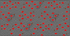
Here's a little overview of the possibilities again:

- Red dots -> possible special locations
- Orange dots -> possible special locations, though only if the red dots next to them aren't specials
- Yellow squares -> possible huts
- Blue dots -> interesting city sites (with regard to the specials)
funxus
Orange Cycloptic Blob
I made a map like DVR and discovered that there are 3 different positions we could be in. Two of them were gave pretty similar surroundings to us and are marked in dark-green on the map, and the third is not very good because that'd mean we are in the middle of a no-special area and is marked with orange.
If we discover a special to the south and then east of the archer, all the green squares are true, if not - the closest special is the orange dot.
EDIT: I see DVR beat me to it...
If we discover a special to the south and then east of the archer, all the green squares are true, if not - the closest special is the orange dot.
EDIT: I see DVR beat me to it...
Attachments
DvR
½ man, ½ amazing
EDIT: heheh, srry funxus 
I think the southern settler is standing in an acceptible position to build a city... If we'd want the northern settler also to build a city quickly, i think the grass square at the upper blue dot is the place..
My idea would be to let the southern settler build a city where he stands, and the northern settler to move to the shielded-grassland square and build a rode onto it, while the archer explores some more terrain in the south-east..
funxus
Orange Cycloptic Blob
funxus
Orange Cycloptic Blob
Thanks, but is the file deleted from the server or just not shown in the post?
DvR
½ man, ½ amazing
Yup, I've used those aswell...
And about the pics, i'm hosting them on another server..
You could offcourse sign up for a free webhosting account to host the bigger images..
And about the pics, i'm hosting them on another server..
You could offcourse sign up for a free webhosting account to host the bigger images..
I will have a reply to attachment deletion after I edit this post.
Edit 1: The attachment address is: http://forums.civfanatics.com/attachment.php?s=&postid=848219.
Edit 2: Hmmm, it looks like it just removes the attachment link from the post and doesn't remove the attachment from the server. Maybe I should go ask about this in Site Feedback?
Edit 3: Bah, it's gone, it just took a while.
TheViking
The world is not enough
I'm posting yet another image ") showing a few possibilites.
showing a few possibilites.
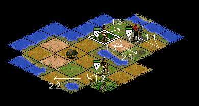
The numbers indicate how I think our units should be used, they include a turn number, a dot and to the right of the dot a number indicating the order in which the units should be moved within the turn in question. I'm taking possible resource locations into account.
This means the first thing I'd like to be done is moving the archers unit SE to reveal terrain.
Depending on what this reveals the 'southern settler' should either found a city immedately where it is (if something nice is revealed by the archers) or move (1.2). Also depending on what the archers reveal the 'northern settler' should either move NE and found a city there or SE to eventually found a city E or SE of the lake.
Movement 2.2 is an interesting possibility since that city site may have access to specials and also the small lake means an inland city on its other side could build ships if desired and send them 'through' the coastal city. I also think we should found a city no later than following movement 2.2, the longer it gets delayed the farther behind the other civs we fall.
showing a few possibilites. The numbers indicate how I think our units should be used, they include a turn number, a dot and to the right of the dot a number indicating the order in which the units should be moved within the turn in question. I'm taking possible resource locations into account.
This means the first thing I'd like to be done is moving the archers unit SE to reveal terrain.
Depending on what this reveals the 'southern settler' should either found a city immedately where it is (if something nice is revealed by the archers) or move (1.2). Also depending on what the archers reveal the 'northern settler' should either move NE and found a city there or SE to eventually found a city E or SE of the lake.
Movement 2.2 is an interesting possibility since that city site may have access to specials and also the small lake means an inland city on its other side could build ships if desired and send them 'through' the coastal city. I also think we should found a city no later than following movement 2.2, the longer it gets delayed the farther behind the other civs we fall.
GenMarshall
High Elven ISB Capt & Ghost Agent
*Cough*
The Military Advisor speeks, We should use that archer to explore the unexplored lands around us") .
.
The Military Advisor speeks, We should use that archer to explore the unexplored lands around us
.Shahadet
Naga Guardian
DvR and Funxus,
Could you tell me what you are using to create these images? Do you not need to know the seed of the map to determine these special locations and hut positions? Please explain your methods to me as I am quite intrested in them.
Also do I have to use a webpage to display pictures on this forum?
Thank you
- Status
- Not open for further replies.
Similar threads
- Locked
- Replies
- 31
- Views
- 733