Rhye's Earth map (180x180)

Rate this map

  • 5/5: The best Earth map ever made

    Votes: 57 32.9%
  • 4/5: One of the best maps, it still needs improvements

    Votes: 88 50.9%
  • 3/5: Nothing particular compared to other Earth maps

    Votes: 15 8.7%
  • 2/5: The level of details sucks

    Votes: 1 0.6%
  • 2/5: The projection sucks

    Votes: 3 1.7%
  • 1/5: Please study mapmaking before posting again

    Votes: 9 5.2%

  • Total voters
    173

Rhye

's and Fall creator
Joined
May 23, 2001
Messages
9,895
Location
Japan / Italy / Germany
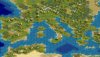
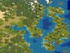
This is my version of Earth map.
It is a modified version of Robinson's projection: Europe is a bit larger and some other corrections were needed to fit the Robinson's map into a rectangle.
Land ratio is 39.7%
As there is no more the rating system, I'll post a poll.

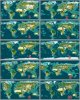
All versions available. (v1.5)
Conquests version include starting locations for the new civs, marshes and volcanos, and the new resources.

NOTE (for Conquests only): as Ottomans and Byzantines share the starting location (Istanbul=Costantinople), Ottoman moved a couple of tiles SE, in the place where their first capital, Yenisehir is. So, it is suggested to replace Istanbul with Yenisehir.
------------------------------------------------------------------------
A 170x170 version of this map has been made and is available here:
http://forums.civfanatics.com/showthread.php?s=&threadid=77848


now, the files

(version 1.0 (no resources) removed after 44 downloads)
(version 1.1 (no resources) removed after 47 downloads)
(version 1.4 removed after 24 downloads)
(version 1.5 removed after 124 downloads)

BIC:
 

Attachments

  • rhyes_earth_map_180x180_v151.zip
    40.2 KB · Views: 10,103
Screenshot #1: the world (standard version)
 

Attachments

  • rm15cfc.jpg
    rm15cfc.jpg
    77 KB · Views: 17,094
A comparation between other maps:

1. mine
2. kal-el's
3. zeb fisher's
4. marla singer's
5. elmencey's
6. teturkhan's
7. arne's
8. ???
9. thestonesfan's
10. aeldrik's
 

Attachments

  • maps_compar_cfc.jpg
    maps_compar_cfc.jpg
    84 KB · Views: 14,942
Nice work :) Just out of curiousity, how long does a map like this take to create?
 
It looks great! IMO, these are the best kind of maps - not too big, but distorted so Europe is much more interesting. I may use this one instead of my own.

BTW, of those you compared it with, no. 9 is mine. ;)
 
Originally posted by thestonesfan
It looks great! IMO, these are the best kind of maps - not too big, but distorted so Europe is much more interesting. I may use this one instead of my own.

BTW, of those you compared it with, no. 9 is mine. ;)

I tried to make a more playable Europe without in my opinion distorting too much. In fact this projection was the most suitable for this purpose. The screenshot #1 shows that Spain, Portugal and Rome should have enough room to found 4 cities each

BTW, I've put your name in the mapmakers list.

Oh, one more thing:
please vote!
 
The map looks perfect for an Imperialism scenario. I'd say the distorsion is very well done and many areas look very nice.
Main shortcoming, some areas (like Tibet) are too much of one type. So shape = very good and terrain = needs some more work.

If you corrected that I would probably go for 4/5 (which is a very good mark AFAIC).
 
Originally posted by Rhye


I tried to make a more playable Europe without in my opinion distorting too much. In fact this projection was the most suitable for this purpose. The screenshot #1 shows that Spain, Portugal and Rome should have enough room to found 4 cities each

BTW, I've put your name in the mapmakers list.

Oh, one more thing:
please vote!

I voted 4/5. I can't say it's the BEST, I'd probably have to give that honor to TEThurkhans. But that is way to big for me to play! :D For playability purposes, this might be the best. But, I do plan on fixing mine up for Conquests, so you might have some competition! ;)

As for suggestions, I'd just recommend putting some hills or something in Tibet. Just to make it somewhat settleable. But, it looks like you are going to fix that for the Conquests version.
 
I'm correcting it now. But I'm not convinced that hills are the solution. I'll put some more in some regions, but I'm working in the meantime on the plateau graphics for Conquests, because you CAN'T say that a place located in Tibet at 4000 mt height is on a hill!
 
Rhye, hills don't represent the same thing along where they are. They are people in Tibet and valleys. Some areas can be high but livable while some are extremely high. So I think the first case can be "represented by" hills while the second can be "represented by" mountains and snow-capped ones.

Moutains in Civ3 are more a reference to nearby terrains/altitudes than a typical mountain. What is anyway ? Mountains in the Andes or in Rwanda are heavily populated which Civ3 mountains cannot represent, hence the need (IHMO) to vary the terrain, not along average heighth but along shapes and population.
Anyway this is YOUR map so you can do what you want. You have just done a splendid job to represent Europe like that (convenient for Civ or for scenarios), I just think you could make it real great with a little more work but I am in now way (how could I anyway) forcing you. :goodjob:
 
Hmm...I wonder if you could make some landmark mountains and have them be settleable?
 
No. I'm going to make plateau = LM mountains, non settleable, because you can't change that setting with LM terrains.
You could make low mountains = LM hills, but I'll use LM hills for "forests on hills", which is a great lack in civ3 terrain system
 
Oh well. It's not like I'm going to ever have Tibet in any of my games anyway! :)
 
Top Bottom