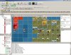
A very powerful Map editor for civilization and it's different tastes.
It learns from XML files so you can create scenarios for almost any modification as well.
See the Official Thread for more infos and updated files or more plugins.
This description is probably not as up-to-date as the thread.
3700 downloads in ~8 months, wow")
Please upgrade to 2.0.9!
Most important changes:
Btw: Most of the functionality of the TeamReveal Plugin can be reached with a right click on the drop-down-menu that let's you chose the teams.

Downloads:
3rd Party Icons & Buttons
Included Plugin Versions

To run the software you might need to install this from microsoft:
Microsoft Visual C++ 2005 Redistributable Package
Other Plugins / Versions: (just extract to mapview directory)
Please be aware of the fact that MapView does not understand *.wbs (civ/warlords/colonization/bts etc.) files 100%. But this will be looged. You can currently not alter all values but A LOT of things can be done.
If you have little feature wishes i can probaly write a plugin very fast. So ask for it!
When you know how to do it you can add render/gui support your a feature or bonus of your own mod within seconds. But even if you don't, MapView will be able to use it anyway.
Feature List:
Video Tutorials:
FAQ:
Changelog:
Credits:
It learns from XML files so you can create scenarios for almost any modification as well.
See the Official Thread for more infos and updated files or more plugins.
This description is probably not as up-to-date as the thread.
3700 downloads in ~8 months, wow
Please upgrade to 2.0.9!
Most important changes:
- 2.0.6 to 2.0.7
- The app took ages to start when working offline due too many connection timeouts to wait for. Improved that.
- 2.0.5 to 2.0.6
- MapView now checks for updates on Application start. (Plugins as well as MapView itself)
- Added Warlords specific saving procedure.
Btw: Most of the functionality of the TeamReveal Plugin can be reached with a right click on the drop-down-menu that let's you chose the teams.
Downloads:
3rd Party Icons & Buttons
- Thx to Jabarto
- Rubber
- Apples
- Salt
- Olives
- Obsidian
- Tobacco
Included Plugin Versions
- Editor 1.3.1
- CreateCoast 1.0
- Remover 1.0
- RiverPlace 1.0
- TileToText 1.0
- LandscapePlacer 1.1 (Current: Version 1.2.0)
- TeamReveal 1.0
To run the software you might need to install this from microsoft:
Microsoft Visual C++ 2005 Redistributable Package
Other Plugins / Versions: (just extract to mapview directory)
- Pic2Map - Convert Pictures to Maps (download and put into mapview dir)
- Use *.jpg files .. you can use other types but that will probably look really horrible ;D
- Currently the map size created will be 128 in width and you cannot change this. I hope you can life with this for now.
Please be aware of the fact that MapView does not understand *.wbs (civ/warlords/colonization/bts etc.) files 100%. But this will be looged. You can currently not alter all values but A LOT of things can be done.
If you have little feature wishes i can probaly write a plugin very fast. So ask for it!
When you know how to do it you can add render/gui support your a feature or bonus of your own mod within seconds. But even if you don't, MapView will be able to use it anyway.
Feature List:
- Maps up to 400x400. (enought?)
- Fast OpenGL Renderer
- Plugin System
- Full mod support. Some restrictions exist, read the FAQ.
- Warlords and submods
- BTS and submods
- Bonus
- Terrain
- Features (no variety tho)
- Improvements
- Cities
- Units
- Rivers
- Players
- Teams
- Renderer an be teached how to render new bonuses, features etc.
- GUI can be teached to display correct buttons for new bonuses, features etc.
- Copy, Cut & Paste
- Layers
- Move Layers
- Flip layers horizontal/vertical
- Merge layers
- Please create some and post them I did the coding, you do the beauty
Video Tutorials:
- Make MapView Render mod specifiy Features, Bonuses, Improvements, Routes ... it's so easy
- Make MapView show custom buttons for mod specific Features, Bonuses, Improvements, Routes ... and UNITS
- Starting positions aren't adjusted when flipping layers.
- Rivers on the most south or most east edge of a layer are not flipped 100% correct.
- ... things the FAQ mentions
- Floodplains look like Jungle! .. Could someone please create a nice grafic for it and share?
FAQ:
- How do i use the TeamReveal Plugin?
Basicly you use the left mouse-button to "paint" reveal and the right mouse-button to "paint" hidden areas.
A right click on the team-selection drop down will bring up a context menu with a few further features. The option to completely hide the whole map from all teams can be reached via the "Plugins->TeamReveal x.x" menu. - Why are there so many ? - Buttons?
Questionmarks are harmless.
The main goal of MapView is to have a few restrictions possible. It works with almost any mod and can place and delete things i couldn't know about when i wrote the program. MapView is also able to be teached by the users, buttons can be created and adjusted. The questionmark just means noone has ever created a button for a specific terrain/bonus/feature/route/uni for improvement. You could easily create some buttons if you wanted to, check out the video tutorials. - The application crashes on startup, what to do?
Try starting MapView without plug_editor.dll to be present in the App folder. If it works now there is some issue with an xml file i don't handle. Use this version of the editor to find out which file is causing the error. Please upload the file somewhere and send me a PM. - The application crashes when changing to another mod?
Use this version of the editor to find out which *.xml file is causing the error. I probably have an unhandled case. Please upload the file somewhere and send me a PM. - Why is some terrain black
This indicated that the file has no terrain. This can happen when using cut. It's not bad tho. That way you could save yourself some bonus settings or similar and then easily paste it into your current map project without modifying the terrain. - How do you navigate? Scroll and zoom?
Whenever you hold down "SPACE" you can use the left and right mouse button to navigate and zoom. Even if you have a tool selected. It's similar how 3d software works so it should quite familiar for a few people and once you know it it should be pretty natuarl. - The toolbar entries of the mod is incorrect
MapView requires everything to start with the usual identifier. BONUS_, FEATURE_, LEADER_ and so on. Some mods (like American Revolution) don't work like that (AMREV_BONUS_SOMETHING etc.) - How to delete Bonus, Features, Routes, Improvements?
Use the eraser and click on ANY bonus, feature, route or improvement. If you last clicked on a bonus, bonuses will be erased etc. - How to delete Cities and units?
Whenever you click on a tile containing units or a city the "Tile inspector" will show those types. You can right click on a unit or city and delete it. Units can also be deleted by pressing the delete key on your keyboard. - How to delete River?
Make sure you enabled the riverplace tool. Hold down the right mouse button while moving the mouse.
You can delete a whole river from source to mouth by holding down shift and then left-clicking on a river. - Some textures look wrong
Make sure all files in the directory /Texture/[Subdir]/ have the same dimensions. If this happens when you use an unmodified version please report it. - What do the question mark symbols on the map mean?
This is when the render engine didn't find a picture that has the same name as the feature, bonus, improvement or route.
You can easily create your own art work. Check the video tutorials to learn how to do this or check the SDK folder for template files to start creating the files for your personal mod.

- Where do i need to install the Plugins to?
The plugin itself has to be in the same folder as the application executable. Usually /MapView/. You should be fine when extracting the plugin to this folder. - How do i disable a plugin?
- Rename the plugin so it doesn't start with 'plug_' anymore
- or just remove it from the directory
Changelog:
- Application:
- 2.0.0 to 2.0.1
- added zlib1.dll to the package
- included LandscapePlacer Plugin to the package
- removed unnecessary files and folders i forgot to remove
- 2.0.1 to 2.0.2
- Editor 1.1 now ships with the application
- Fixed a bug about hills and peaks beeing reversed (Thanks to ayse)
- 2.0.2 to 2.0.3
- Editor 1.2 now ships with the application
- 2.0.3 to 2.0.4
- Fixed bug that made almost everything appear in white and repacked
- 2.0.4 to 2.0.5
- Included Buttons for Stock Units
- Improved parsing/saving
- 2.0.5 to 2.0.6
- MapView now checks for updates on Application start. (Plugins as well as MapView itself)
- Added Warlords specific saving procedure.
- 2.0.0 to 2.0.1
- Editor:
- 1.0 to 1.1
- Clicking on the Toolbars (Feature, Route, Bonus, Improvement, Unit) will now automatically activate the pen when you just used another plugin like RiverPlace or LandscapePlace. Pensize will stay as you selected.
- 1.1 to 1.2
- Had to recompile due to drastic api changes.
- 1.2 to 1.3
- Added landmass selection
- 1.3 to 1.3.1
- Fixed from description for the box selection tool in the selector drop down menu
- 1.0 to 1.1
- LandscapePlacer
- 1.0 to 1.1
- Peak and Hills were reversed, fixed that (Thanks to ayse)
- 1.0 to 1.1
- TeamReveal
- 1.0
- first release
- 1.0
Credits:
- JEELEN (for answering stupid questions about the '.xml structure)
- Rhye (for answering stupid questions about the '.xml structure)
- Dale (for his incredible!! In depth look at the WBS file)
- asioasioasio (for beeing beta tester and since he kept asking for the release)
- everyone that made me spend a few hundred hours in this