Snoopy
Prince
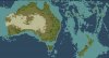
Yeah, so I am making an accurate and realistic map of Oceania, before colonization (so no sheep in New Zealand).
At first I found it a little difficult in making the map, but I found a method that allows me to create almost perfectly accurate maps in a VERY short time.
I still have to finish Australia and the Pacific Islands.
To get the most accurate map, I of course used the largest size possible. (You can build 3-4 decent sized cities on New Zealand, which is accurate in the real world). And yes I'm aware Papua New Guinea is normally considered part of Oceania, but adding it would have shrunk New Zealand too much. (You'd get 2 cities instead of 4). I'll probably do a South East Asia map which will include Papua New Guinea.
After this I will continue to do the rest of the world, continent by continent.
One question, has anyone figured out how to increase the size of the map above its current highest size?