Alagaesia

The Midge

Chieftain
Joined
Jan 8, 2013
Messages
24
Location
Mordor,Mallorea,Surda,Cyrodiil
ALAGAËSIA

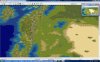
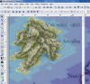
My variation of Alagaësia, there are plenty out there, so only download this one if you really think it's better or more suited to your tastes. If it does, thanks!

The way I created the outline for the map was to download a map of Alagaësia and turn it slightly transparent, I then screenshot the editor and mapped out the squares on the map.

Due to the 60 MB limit of space, you will now find the maps here; http://themidge.aberlehouse.us/
 

Attachments

  • Alagaesia 01.jpg
    Alagaesia 01.jpg
    247.8 KB · Views: 1,120
  • Accuracy.jpg
    Accuracy.jpg
    77.9 KB · Views: 528
  • Alagaesia 02.jpg
    Alagaesia 02.jpg
    244.2 KB · Views: 1,238
  • Alagaesia 03.jpg
    Alagaesia 03.jpg
    245 KB · Views: 606
The way I created the outline for the map was to download a map of Alagaesia and turn it slightly transparent, I then screenshot the editor and mapped out the squares on the map.
There's a utility made by Neptun1976 that I use, which already does this.
Bitmap 2 BIQ
Its good to see more maps being made and I hope this helps.
 
Nice map. It does look a lot like the map in the books. I feel it would really shine if it was modded a bit, though: use of LM terrain, jungle tiles, and heavily modified tundra tiles to make the terrain less monotonous, and custom terrain graphics to make the giant mountains (Beors?) look big as well as changing volcanoes to the fire pits on the barren plain. (Cattle and sugar are there?)

Otherwise, I like it. I haven't read the books since the last one came out, but it seems accurate otherwise.
 
LM tiles have separate graphics files and can have different food/shield values than the normal terrain. For example, you could make a separate graphic for LM mountains that looks like the Beors and place those tiles where they belong. You can also change their stats so they are rich in food and you could theoretically have a civ settling where the dwarves would live.

The editor also allows you to change the names of terrain, so you could change "Jungle" to "Deep Forest" and change the graphics to look like it. Their stats could be different so it would be possible for a civ to thrive there without chopping all the forests. It also makes the terrain look more interesting. Tundra could be renamed to "scrubland" or another terrain type that would exist on the map and its graphics could be changed to such so it would get used in some way.

But you don't have to do all that to the scenario file if you don't know how. It's still pretty cool without those little changes.:goodjob:
 
Redoing the volcanos to look like fire pits is a great idea. The eruption animations would be a great addition. I'll have to consider doing that with some underworld lm terrain.
I tried to mod tundra and make scrubland, I couldn't do it though:sad:
Modding terrain can be tough. One way to start is to find terrain close to what you want & cut and paste it into a terrain file to combine it with other terrain. To do the best job of this change your working file to rgb, combine, then re-index it to 256 colors. Or just rename a suitable file if you van find one. A third solution for the tundra would be to change the tundra part of the forest pcx to make a "scrubland" overlay.
 
ALAGAËSIAThe way I created the outline for the map was to download a map of Alagaësia and turn it slightly transparent, I then screenshot the editor and mapped out the squares on the map.
There's a utility made by Neptun1976 that I use, which already does this.
Bitmap 2 BIQ
After struggling for years painting tile by tile I came to making maps this way. It's more complicated to describe than it is to do. Basically - the reference map is the bottom layer. Paint on a separate layer with just coast & plains. Paint other terrains as separate layers - grass layer above plains, hills & mountains above grass. Start with a large source image & you can be fairly sloppy with the placements. Then Flatten the image, scale (without anti-alias) to the size needed for bmp2bic, make sure the palette matches, then generate the map. A little more cleanup in the biq editor & you've got a decent map.
 
After struggling for years painting tile by tile I came to making maps this way. It's more complicated to describe than it is to do. Basically - the reference map is the bottom layer. Paint on a separate layer with just coast & plains. Paint other terrains as separate layers - grass layer above plains, hills & mountains above grass. Start with a large source image & you can be fairly sloppy with the placements. Then Flatten the image, scale (without anti-alias) to the size needed for bmp2bic, make sure the palette matches, then generate the map. A little more cleanup in the biq editor & you've got a decent map.
Finally had a chance to try this out, but oddly I have more patience placing hills and mountains one tile at a time. However this did come in handy for accurate city placement by overlaying a map with city names over the base map.
 
After struggling for years painting tile by tile I came to making maps this way. It's more complicated to describe than it is to do. Basically - the reference map is the bottom layer. Paint on a separate layer with just coast & plains. Paint other terrains as separate layers - grass layer above plains, hills & mountains above grass. Start with a large source image & you can be fairly sloppy with the placements. Then Flatten the image, scale (without anti-alias) to the size needed for bmp2bic, make sure the palette matches, then generate the map. A little more cleanup in the biq editor & you've got a decent map.

Umm, I'm not sure what you mean.
 
Umm, I'm not sure what you mean.
Considering how much is in what you quoted - not to mention the explanations linked from it - that's a pretty broad area. Could you be more specific about what part of all that you don't understand?
 
Considering how much is in what you quoted - not to mention the explanations linked from it - that's a pretty broad area. Could you be more specific about what part of all that you don't understand?

Mostly the layers, and then the generation of the map, I'm not sure how you got it to give you the map you wanted.
 
Mostly the layers, and then the generation of the map, I'm not sure how you got it to give you the map you wanted.
Still vague but getting "it" narrowed down a bit.

  • Do you not understand the use of layers in graphics applications such as gimp or photoshop? Or is it that you don't understand how I applied the technique to making as map?
  • Are you unfamiliar with BMP2BIC? Or is it that you don't understand how I made a suitable graphic for it to process?
At this point I don't have the time to write more expansive tutorial that involves an extensive rewrite of any of those posts. If it's a matter of still not understanding the linked posts after carefully and thoroughly reading them then I'm happy to answer specific questions about the techniques used. In any questions you post please refer to something specific that I wrote - don't know how else to tell what it is that you don't understand. Which prevents me from helping you.

If it's a matter of learning how to use software written by other people then there are other appropriate places to look for help. CFC threads specifically about utilities such as BMP2BIC which were created for modding C3. Books, other forums, on-line tutorials, etc. for software such as gimp or photoshop.
 
Read about BMP2BIC here.

That should make the second post I linked to above more transparent.

Fundamentally, BMP2BIC converts any image from .bmp format into a BIC to be edited in the C3 Editor. So use any graphics software that can save an image as a .bmp file. Any image can be the source. The .bmp has to meet certain requirements for dimensions and colors used in the image. Those parameters are laid out in the BMP2BIC thread and in the post I provided a link to.

Hope that gives you a general idea. I'm happy to answer further questions. But it's probably better to ask them in the BMP2BIC thread - not here.
 
I've used BMP2BIC in the past, but ultimately what I prefer to do is get the image I will be basing the map on, and shrink it so the pixels match the game tiles - ie the image is 362x362 pixels if I am making a 362x362 map. Then I just match pixel to map tile.

I prefer the manual way, as my experience with BMP2BIC is that it gets the tiles about 80-90% right, so you usually have to go back and clean up quite a bit. It also requires you to get the base image pallette right, and IIRC cannot place Marsh or Volcano tiles, let alone rivers. All that cleanup and correction (IMHO) takes more work than doing it manually from scratch - but to each his (or her) own!
 
Top Bottom