GRM7584
King
Exported these from my Colonize! mod, and modified them slightly for general public use.
Things of note:
No resources placed.
No starting locations placed.
No volcanoes placed; easy to set if you want them, right?
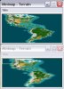
In the small map, the Pacific Northwest is distorted.
The map touches the northern polar cap, and thus will work best with a terrain set which takes this into account (such as Rhye's). Otherwise, it is recommend that you turn polar ice caps off.
Things of note:
No resources placed.
No starting locations placed.
No volcanoes placed; easy to set if you want them, right?
In the small map, the Pacific Northwest is distorted.
The map touches the northern polar cap, and thus will work best with a terrain set which takes this into account (such as Rhye's). Otherwise, it is recommend that you turn polar ice caps off.