I figured we should have a page dedicated to pictures. Let's try to keep comments to a minimum in here so we mainly view pictures. If you have a valuable pic from another thread throw in here as well. Anyone want the responsibility for being our "official cartographer"?
- Home
- Forums
- OUR ARCHIVES
- List of Archived Forums
- Civilization III Archives
- Civ3 - Multi-Team Demogame
- Team K.I.S.S.
You are using an out of date browser. It may not display this or other websites correctly.
You should upgrade or use an alternative browser.
You should upgrade or use an alternative browser.
Cartography Room
- Thread starter Whomp
- Start date
soul_warrior
Termite!
since it would likely be a while before i can sharpen my stick at the explosive bunch, i will take on the cartography offices.
good thing too, as i have studied Geography at UNI. (got bored out of my skull and left, but i did 4 terms).
will take a look at the latest save when i get home and post some screenies.
good thing too, as i have studied Geography at UNI. (got bored out of my skull and left, but i did 4 terms).
will take a look at the latest save when i get home and post some screenies.
soul_warrior
Termite!
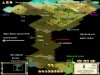
this is the first of many maps.
the knowledge contained within is based on the merry adventures of PeaPants and rumors brought and bought from many a wild tribesmen.
heed the warnings, and step on the poo at your own risk.
this carthographer shall be liable to any harm done to your soul, unless caused by idiocy.
in that case we'll just have a laugh
Attachments
Daghdha
Absent Minded
Butterball
Bear
I have a dumb question, I'm sure it's basic knowledge.
When I look at a map, the orientation is canted to the left or North Norht West. Is North the top of the screen or the NNW cant? I'm trying to follow the discussion and this bugs me. So, in the map above (@DAGH) is "Prolly the Gap" pointing North or North North East?
BB
When I look at a map, the orientation is canted to the left or North Norht West. Is North the top of the screen or the NNW cant? I'm trying to follow the discussion and this bugs me. So, in the map above (@DAGH) is "Prolly the Gap" pointing North or North North East?
BB
soul_warrior
Termite!
the arrow points north
Tubby Rower
Chronic Slacker
up = north.
the tiles are squares turned 45°. So you are moving across a "corner" of the tile if you move north (or any other cardinal direction). If you move NE then you move across a side of the square. In most of these pics the grid is not turned on.
the tiles are squares turned 45°. So you are moving across a "corner" of the tile if you move north (or any other cardinal direction). If you move NE then you move across a side of the square. In most of these pics the grid is not turned on.
Tubby Rower
Chronic Slacker
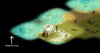
I pieced together 3 screen shots for this... There's the other continent on the west edge of out view
With Grid lines just for Bugsy
With Grid lines just for Bugsy
gmaharriet
Ancient Crone
Do I detect a bit of irony there?Tubby Rower said:With Grid lines just for Bugsy
") Anyway, I'm always grateful for gridlines, as I have great difficulty gauging distances/locations without them.
Anyway, I'm always grateful for gridlines, as I have great difficulty gauging distances/locations without them.Good job on putting the entire map together, TR. It will be interesting to find out which team is north or south on the other continent. Also, if the map is truly balanced, did MIA find that northern crossing or its southerly mirror?
Tubby Rower
Chronic Slacker
From MIA:
The D'nut boat came from the east.
I take that to mean that there is a southeastern nub like our NW one. So the continents are similar to a backslash and a forward slash put together ie
The D'nut boat came from the east.
I take that to mean that there is a southeastern nub like our NW one. So the continents are similar to a backslash and a forward slash put together ie
Code:
 / \
/ \ /Tubby Rower
Chronic Slacker
Here is the enhanced map with a couple of things pointed out in case your eyes aren't superhuman.
of things pointed out in case your eyes aren't superhuman.I have that same problem. I always play with grids or else I move units the wrong way.gmaharriet said:Do I detect a bit of irony there?
Good job on putting the entire map together, TR. It will be interesting to find out which team is north or south on the other continent. Also, if the map is truly balanced, did MIA find that northern crossing or its southerly mirror?
Sir Bugsy
Civ.D.
Thanks for the grids.
Daghdha
Absent Minded
Beorn-eL-Feared
Idiot riding pedals
Fortify and open negociations while he heals?
Daghdha
Absent Minded
@B-e-F
Yeah, I guess so. Tubby thinks maybe MIA is short of defence and afraid we'll pop Barbies. We could wait til they've finished that hoppie or whatever.
Yeah, I guess so. Tubby thinks maybe MIA is short of defence and afraid we'll pop Barbies. We could wait til they've finished that hoppie or whatever.
Nikodemus
Demigod
I don't think we'd appreciate if they started popping the Ghuts near our core. In my opinion it would be reasonable and fair to just leave it alone if they so wish. That way we can hopefully expect them to do the same.
Tubby Rower
Chronic Slacker
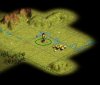
Here is the new map with the civ's borders outlined
EDIT:: updated
EDIT:: updated
Tubby Rower
Chronic Slacker
EDIT: here is our core @ turn 45
Minimap superimposed for Sir Bugsy
Minimap superimposed for Sir Bugsy
Similar threads
- Locked
- Replies
- 21
- Views
- 2K
- Replies
- 34
- Views
- 1K
- Replies
- 100
- Views
- 7K