Deepwater harbours

Civinator

Blue Lion
Supporter
Joined
May 5, 2005
Messages
8,882
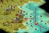
At www.civmods.com there is an -in my eyes - astonishing scenario: Age of Piracy 3.0 written by Shay Yates Roberts. He managed, that a sea-tile has a direct connection with a land tile (without having a coast tile between the seatile and the landtile.

Now with giving the ships that can only move on sea- and oceantiles the "wheeled flag" and the coastal tiles the flag "forbidden for wheeled units"
the creator could manage that the seagoing vessels could only move to special harbours and can be attacked by smaller vessels that have a movement advantage in coastal tiles.

Has anybody an idea and can tell me how it was managed to get the sea-tile next to the land-tile ? Everytimes I tried that, I destroyed the land tile with a coastal tile.
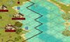
 

Attachments

  • Deepwater harbour.JPG
    Deepwater harbour.JPG
    80.5 KB · Views: 1,145
Thank you for your answer LizardmenRule,

the scenario has landmark terrain for sea and coastal tiles. On the editor the landmark terrain is marked with a yellow diamond. The sea terrain , marked in the first picture with a red circle is no LM-terrain. When I replace that sea terrain with a sea-LM terrain, Richmond dissapears in the sea.

So I guess it must be something other.
 

Attachments

  • Deepwater harbour 2.JPG
    Deepwater harbour 2.JPG
    51.7 KB · Views: 327
Ok, this is a mini-bump because I fear otherwise this thread will die slowly in the meanderings of the forum pages. The thing is I really need this information for a scenario I'm creating.

I've sudied the biq file and I tried many option, but I wasn't able to understand how this was realized. If you right-click on the square with the little blue ship's weels in the editor, it says it is a sea square, even though it has the graphic of a coastal square. As soon as you modified something in the water (i.e. you add a sea square in the ocean or a coastal square in the sea) these abnormal coastal square with sea properties disapear. :confused:

If someone know how to achieve this phenomenon, it could open a lot of new windows for scenarion making!
 
To answer the questions from the other thread we were slowly hijacking ;)

With MapTweaker you can place any tile anywhere, e.g. an ocean tile inland, or a sea tile in the same way it's been done in that scenario. I can confirm it works in-game, though unlike the Age of Piracy scenario it has graphical glitches that I'm not sure how to overcome (when you use MapTweaker you'll see what I mean).

Making any modifications to the map (not the rules) in the C3C editor causes blending of terrain, and any invalid tiles applied with MapTweaker are lost.

EDIT: Note that if you make any changes to this scenario's map, it behaves exactly as a maptweaked file - all the deepwater sea tiles are lost.
 
Done
Ok since I had my own personal Caribbean scenario this thing got me really interested ;) In order to make it work and look nice at the same time, you need to manually edit the BIQ file in a hex editor. It's scary but once you grasp the basics, editing is easy and fast.

You need MapTweaker and a hex editor capable of binary comparison - there are free/shareware ones, I used HexCmp as suggested by google. Your BIQ file must have BIQ-compression turned off (in the C3C editor).

1. Make a copy of your BIQ1, I'll call it BIQ2. Also make another copy that will be a backup in case something goes wrong.
2. Open BIQ2 in MapTweaker and add sea tiles in chosen locations; Save.
3. Open both BIQ1 and BIQ2 in HexCmp.
4. Using HexCmp's "Find Next Different" button, look for differences; the only ones that are of your interest are BB values in BIQ1 that are CC in BIQ2; Replace these BBs in BIQ1 with CCs. Ignore the rest; Save.
5. Close HexCmp and delete BIQ2. Your original BIQ should now have Sea tiles at chosen locations, but the map will look unchanged (e.g. they will look like Coasts, no glitches).

Reminder: make a backup :)
EDIT: Reminder2: once the changes are done, you cannot edit the map in the C3C editor or the sea tiles will change back into coast. Editing rules, scenario properties is fine. Adding resources, units etc. is fine as well, just not any terrain editing.

BTW this requires getting used to some values (by now we know that BB is Coast and CC is Sea) but you can do some wicked stuff with method e.g. sea/coast tiles that look like grasslands in-game, or grasslands that look like mountains etc. Not sure what for, but it's possible. This is awesome IMO ;)

EDIT: I added pretty pictures that illustrate MapTweaker and HexCmp usage to add a deepwater port in Havana:

MapTweaker


HexCmp


The result - just drop a resource e.g. an anchor if you want it marked somehow
 
Whoa this is extremelt interesting stuff. I am going to have to experiment with it.
embryodead said:
Ok since I had my own personal Caribbean scenario
I have been working on my own Pirates of the Caribbean scenario and made a 180 x 180 map for it. I would be interested to see what you made.
 
I have been working on my own Pirates of the Caribbean scenario and made a 180 x 180 map for it. I would be interested to see what you made.

I'm using this, it's a 160x100 map I modified/extended starting with the 140x100 map by jatibi.


OMG. I'm speechless. Any other tweaks you can make in the BIQ?

Well, I can't, unless there's a base for research, like the scenario this thread started from and comparison of two files. There's some stuff that Civ3MT does, like sorting of units/resources/improvements but I don't really know how the BIQ is built.
 
I wonder, then, if this would work:

1. Create 2 scenario files. Have the only differences between them the number of civs and the number of players allowed (Say, 7 civs +7 players, compared to 8 civs and 8 players)

2. Look for the differences

3. Increase both to 32+
 
After some experimentation, here are the values for other tiles:

00 Desert
11 Plains
22 Grassland
33 Tundra
44 Flood Plain
55 Hills*
66 Mountains*
99 Marsh*
AA Volcano*
BB Coast
CC Sea
DD Ocean

* - these are overlays, so they are visible no matter what, though without the base grassland tile
77 and 88 are likely forest/jungle but adding them on invalid tiles crashes the game

In order to turn the tile into LM tile, move 6 bytes forward and change the '00' value to '20'

Apart from Deepwater Harbours, here are some more ideas on how to utilize it (more or less tested):

LM Sea tiles placed in coast/sea/ocean
- Give LM Sea the desired movement cost and rename it to something like Reef or Passage
- Use the MapTweaker+HexCmp method to place Sea tiles but add the '20' value 6 bytes after each 'CC'

Impassable reefs in coast/sea/ocean
- You've got to sacrifice one land overlay e.g. marsh. Rename it to Reef and make it impassable, unless you want land units to be able to move on it
- Edit marsh pcx so that there's nothing in it (and add Reef resource graphic over it) or just put the Reef graphics straight in that pcx.
- Now using the MapTweaker+HexCmp method you can place these neew reef-marshes anywhere on the coast/sea/oceans.

Bridges on wide 'coast' rivers
- Just replace one of the coast tiles with plains and place a Bridge graphic on it as a resource. It still won't let the ships pass but at least look much better.

@Virote_Considon
The game supports 31 civs, BIQ is just data. EDIT: and btw you can do this with C3MT already, and any Civs beyond 31 just don't show up in game.
 
I think it is one of the things that he always wanted the answer to.

Yes this is absolutely true. :) Thank you very, very much for finding this Shay Yates Roberts and embryodead.
The reason, why these deepwater harbours (and the tech behind it) are so absolutely important for modding in my eyes is the following:

If you want that certain frighters with supply units (the reverse capture the flag mod like in AOI) only can reach certain harbour destinations, you can lay different paths by sea-terrain in the ocean-terrain and flag these frighters with the wheeled flag, so that they can only use these paths. Ocean terrain - and now coast-terrain -are forbidden for ships with the wheeled flag. We did this for SOE for ocean terrain. But there always was the problem, that the ships can wander along coast-terrain to other destinations as they were targeted to. Now it is possible, that these ships can only move on a "sea-terrain-line" from one city to the other city. And amphibious operations now can get a new dimension, when in the one city of the "sea-terrain-line", there are autoproduced landing boats and land units and on the other side of the "sea-terrain-line" there is a possible historical landing spot with a victory point on it.

 
Hello all. Thanks very much everyone for your kind words and your interest in map modding. And thanks to the Civinator for calling this thread to my attention. My job has called me away from Civilization, so I no longer have the time I once enjoyed to follow these fascinating discussions. I have to get back to work shortly, so let me say a few quick things. The process used by embryodead to create deepwater ports was similar to the process I used. But embryodead is smarter and more ambitious than me, and is already applying the idea to other things. Good work embryodead! Because I am lazy, I created an Excel spreadsheet to help me crank out these map tweaks in quantity (I did not have the maptweaker utility at the time). The idea is that you take your uncompressed scenario file and open it in a hex editor. Then do a text search for the word "TILE" (all uppercase). Plug the hex location of that word into the spreadsheet, along with the width of your map. Then go into your CivEditor and get the coordinates of the places you want to place deepwater ports, and plug those coordinates into the spreadsheet. The spreadsheet will then calculate what locations in your scenario file have to be tweaked. Here's a link to the spreadsheet. Anyone is welcome to use it, change it, or improve it; though it sounds like maptweaker might be easier. http://civmods.com/CitiesAndPorts.xls I was not able to overcome the problem of the CivEditor rewriting my changes when I further modified my map. So I made sure my map was finished before I added the deepwater ports. -Shay-
 
Hello all. Thanks very much everyone for your kind words and your interest in map modding. And thanks to the Civinator for calling this thread to my attention. My job has called me away from Civilization, so I no longer have the time I once enjoyed to follow these fascinating discussions. I have to get back to work shortly, so let me say a few quick things. The process used by embryodead to create deepwater ports was similar to the process I used. But embryodead is smarter and more ambitious than me, and is already applying the idea to other things. Good work embryodead! Because I am lazy, I created an Excel spreadsheet to help me crank out these map tweaks in quantity (I did not have the maptweaker utility at the time). The idea is that you take your uncompressed scenario file and open it in a hex editor. Then do a text search for the word "TILE" (all uppercase). Plug the hex location of that word into the spreadsheet, along with the width of your map. Then go into your CivEditor and get the coordinates of the places you want to place deepwater ports, and plug those coordinates into the spreadsheet. The spreadsheet will then calculate what locations in your scenario file have to be tweaked. Here's a link to the spreadsheet. Anyone is welcome to use it, change it, or improve it; though it sounds like maptweaker might be easier. http://civmods.com/CitiesAndPorts.xls I was not able to overcome the problem of the CivEditor rewriting my changes when I further modified my map. So I made sure my map was finished before I added the deepwater ports. -Shay-

VERY interesting indeed
 
Top Bottom