GigaGlobe

Owain

G Flashing Inaccessable
Joined
Sep 7, 2003
Messages
219
Location
Tennessee
My first map... I like the idea of using X and Y wrapping and taltho's globe inspired me to try this out. Its a 360X360 world map, set up for 24 civs. I just threw the terrain and resources on there. I'm not happy with it now, so I'll be working on it more, but I thought some people might want to try it out or give me some advice... Mostly, I don't know what to do with the India/Persia area. You can go in a straight line from India to the west coast US and its not as far as it should be. I also had to stretch out Persia like crazy.

Anyway, i just did this free hand. I'm going to sit down with a pencil and paper and try to plot out how to do this better, but any advice would be appreciated.

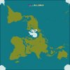
GigaGlobe version 0.1

Preview Attached:
 

Attachments

  • gigaglobe.jpg
    gigaglobe.jpg
    14.1 KB · Views: 1,801
Looks great!:goodjob:
Three things:
1)What is the purpose of X-Y wrapping?:confused:
2) India seems a little cut off...I noticed that because there doesn't seem to be Sri Lanka, and if there is, it's cut off, too.
3)WHAT?! YOU PUT NO FATHER CHRISTMAS UNIT AT THE NORTH POLE???:lol::rotfl::lol:
Other than my one real suggestion, it's a good map all in all. :goodjob: :thumbsup:
 
Very nice map! :goodjob:
 
I put a goody hut at the north pole. :)

I'm starting over ona new map. I traced out a rough draft first this time, so it should be alot better and I'll take the time to place terain and resources acurately. I'll also make a version for TET (which is really what I'm making this to use with myself).

btw, I was looking at this and realized I put Carthage where Constantinople should be. I apologize... My new map will fix that as well. :p
 
Very impressive attempt!

Were it scores 10/10 is in how well proportioned the landmasses are and that it all fits together almost perfectly.


The problem as a whole is the level of detail of the landmasses. Japan, South-East Asia and Norway etc where the choice of terrain is rather poor. I've visited Norway recently and you need ALOT more mountains, hills and forest...at the moment it is mainly grassland and tundra!

Resources also appear not to have been placed with any particular care and I really wonder how well the map would function if the game was played as a result.


First problem to correction: look at the Straits of Gibralter...then look at a map. The same for the Atlantic coast of Morocco.


I'll leave it there as I don't want to be over-critical of such an enterprising map designer as yourself and you ask you to look at making your map more detailed rather than spending more time rearranging continent shape. You'll recognise those problems more aptly when you try to introduce accurate terrain from maps onto your map and then you can adjust accordingly.


So in conclusion, good job so far, do please finish it :)

:goodjob:
 
WOW

that looks beautiful. I love the continental proportions. Thank you. this is the first map I've downloaded and I've been here about a month.Great work.
 
Well, I've still been unhappy with my hand-drawn plots for this, so after doing a little research I found this:


I'm going to go with this projection (The Pierce Quincuncial projection) as a base. I realize this makes anything near the poles much smaller than it should be and things near the equater much too large, so I'll fudge with it to try and get more correct landmasses. But this is really the only one i've found that comes close.
 
Too bad you couldn't do a map on Pierce Quincuncial projection with Antartica in the middle, and the North Pole at all four corners. That way Europe and North-America would be a little too big (which is good for gameplay) and the land-starved Southern Hemisphere would be a little too small (no problem with me). But I imagine that's just a wee bit insane to do... Nice work, though.
 
Hi Owain,
Dont lose faith and give up on this. I mean it this is one of the coolest things I've seen on this site:eek:
@Mithadan you're right that would be cool, but, I doubt any of us would recognise our own planet. Then again seeing home in a new light might hot be a bad thing.
Great work Owain. I haven't worked this map into a mod but I will. It really does beat the hell out of an ordinary map.
 
C'mon, Owain! Color that pic, get the BMP to BIC converter, and ur done! Pleez! Pleez, continue!
 
Looks good from where I'm sitting.
Just how big is europe? How many squares is Italy (as a mental guide for me)
 
Good job, Owain! :thumbsup: The map looks great, and you didn't give up!
 
Wow this looks like a great map, im glad someone finally took use of the x,y wraping!:goodjob: My only wish is if there was a map like this that was a little smaller. I allways hated waiting 10minutes for the AI to move.
 
Very nice ! :goodjob:
If you are still working on it, will you be adding the Conquests civs?
 
Top Bottom