You are using an out of date browser. It may not display this or other websites correctly.
You should upgrade or use an alternative browser.
You should upgrade or use an alternative browser.
Hurricane Ivan
- Thread starter Quasar1011
- Start date
Quasar1011
King of Sylvania
- Ocho Rios still blowing
Date: Sat, 11 Sep 2004 02:57:07 -0500
It is almost 3 am and Ivan is still howling out there. We have lost about 8
trees in our yard and from the reports on the radio, the worst is yet to
come. With the eye passing further south than predicted, we will be spared
some of the strongest winds. Give Thanks!
A lot of people have lost their homes, although I have not heard of any
casualties. Please keep all of us in your thoughts and prayers and we
weather this storm tonight.
_________________________________________________________________
- Ivan the terrible
Date: Sat, 11 Sep 2004 00:43:24 -0500 (Eastern Standard Time)
Ok folks it is 12:30am Saturday morning and Ivan is howling up a storm ... no pun intended! There are sounds outside that make gang wars and gun fights seem tolerable. The winds have definitely picked up here in Montego Bay and things like trees have learnt to walk freely. No vehicles on the road at this time, minimal rain it actually comes in waves of medium drizzles. The wind however, is constant, consistent and makes the Gilbert of 1988 seem as if it was a whirlwind by comparison ... the fact that this is all happening at night, without power does not make it any easier to bear.
In summary, I honestly can only write from what I hear outside, and from the sounds it doesn't sound like I will see much of anything in the morning. I can say that billboards that were in view of my house are gone with the wind. My car alarm has gone off numerous times just from the sheer force of the wind but I guess 140mph winds will do that to any vehicle!
The news has just indicated that Ivan has reduced its traverse speed to 17kmh and that it should become a CCAT5 hurricane before it actually makes landfall. I should note that with all the noise and wind and all I have mentioned here, the storm is still about 90 miles way from montego Bay ... so in a sense its only just begun!
For the persons who asked earlier about the hotels in Montego Bay, at this time I can just say that if they are by the sea, then they are going to be closed for a little while after Ivan is gone. The waves coming into Mobay were not small when the wind was lower, and now that it has really picked up I would imagine that the waves have also grown somewhat.
The scientist in me wants to say that Ivan is the perfect example of a well composed hurricane system ... a beautiful storm, on the other hand, my human side will ask what gate of hell it escaped from.
Anon
Richard
Singularity
Infinite Density
Quasar1011 said:Ivan will then cross over Cuba during the predawn hours on Monday. Again, for much of this period between now and Monday, Ivan could be a Category Five hurricane. The disturbing thing is, the center of Ivan is projected to pass over or near the city of Havana!
That is disturbing indeed. From what I can see it seems like the track of the eye is a bullseye, first on Old Habana, and then straight over Havana. I only hope they have time and resources to take the needed precautions - though with 140-160 mph winds there is not much to do but get as far away as possible I guess.
Lackofthought
Chieftain
- Joined
- Dec 31, 2003
- Messages
- 32
Provolution said:And on 11. September, I hope the Floridans take Ivan as an omen not to mess up the electoral process once again.Very good timing
There was a cartoon in the Washington Post along those lines, it showed Frances', Ivan's, and Charley's paths aiming at a section in Florida labeled convention center or something like that, with god sitting up on a cloud saying something like, "I wonder if they got the message?"
I'm glad I don't live in Florida, they're really gonna need help after Ivan...
Quasar1011
King of Sylvania
Next in Ivan's path are the Cayman Islands. Here is a link to a private weather station on the islands:Cayman Weather
Cuivienen
Deity
- Joined
- Nov 26, 2003
- Messages
- 8,011
Ivan is now Category 5 again, sustained winds of 165 mph. It is now projected to hit the Florida panhandle, not the main regions of Florida. Havana also looks like it will be spared the worst of the storm.
And apparently I just missed the two 1915 hurricanes on the list. Two Category 4 hurricanes made landfall in the US in one year once before, in 1915.

And apparently I just missed the two 1915 hurricanes on the list. Two Category 4 hurricanes made landfall in the US in one year once before, in 1915.
Quasar1011
King of Sylvania
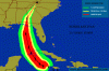
HURRICANE IVAN DISCUSSION NUMBER 38
NWS TPC/NATIONAL HURRICANE CENTER MIAMI FL
5 PM EDT SAT SEP 11 2004
THERE HAVE BEEN SOME GRADUAL CHANGES IN THE STEERING PATTERN OVER
THE LAST DAY OR SO WHICH COULD RESULT IN THE HURRICANE MOVING ON A
TRACK NOT AS CLOSE TO SOUTH FLORIDA. WHILE THIS MAY BE GOOD NEWS
FOR SOUTH FLORIDA...IT IS NOT SO FOR OTHER REGIONS OF THE EASTERN
GULF COAST. WATER VAPOR IMAGES SHOW THAT A RIDGE OF HIGH PRESSURE
AT THE MID TO UPPER-LEVELS HAS DEVELOPED FROM THE GULF OF MEXICO
EASTWARD ACROSS FLORIDA. IT APPEARS THAT THIS RIDGE HAS BEEN
FORCING THE HURRICANE ON A MORE WESTWARD TRACK...DELAYING THE
EXPECTED NORTHWEST AND NORTHWARD TURN. ALTHOUGH THE NORTHWARD TURN
IS STILL FORECAST TO OCCUR AS A WEAKNESS DEVELOPS IN THE GULF OF
MEXICO...IT IS NOW EXPECTED TO OCCUR OVER EXTREME WESTERN CUBA AND
OVER THE OPEN WATERS OF THE GULF OF MEXICO. THIS TRACK INCREASES
THE HURRICANE RISK FOR THE NORTHEASTERN GULF OF MEXICO REGION AND
DECREASES IT FOR SOUTH FLORIDA. THE WESTWARD SHIFT OF THE OFFICIAL
FORECAST REMAINS IN AGREEMENT WITH GUIDANCE WHICH HAS ALSO BEEN
SHIFTING GRADUALLY WESTWARD.
AS WAS THOUGHT POSSIBLE...IVAN HAS REGAINED CATEGORY FIVE STRENGTH.
A RECONNAISSANCE PLANE JUST MEASURED 161 KNOTS AT 700 MB AND AN
EXTRAPOLATED PRESSURE OF 914 MB. THE DROP MEASURED 918 MB BUT IT
HAD 29 KNOTS AT THE SURFACE. INITIAL INTENSITY HAS BEEN INCREASED
TO 145 KNOTS. THERE ARE NO SKILLS IN PREDICTING CHANGES IN
INTENSITY WITH SUCH EXTREMELY INTENSE HURRICANES...SO IVAN IS KEPT
AT 145 KNOTS UNTIL LANDFALL IN CUBA. THEREAFTER...THE SHEAR IS
FORECAST TO INCREASE...SO A GRADUAL WEAKENING IS INDICATED.
NEVERTHERLESS... IVAN IS EXPECTED TO REACH THE UNITED STATES AS A
MAJOR HURRICANE.
FORECASTER AVILA
I'm sitting up here in Mobile with a strange bacterial infection. My girlfriend convinced me to go the doctor, and I told her, "Okay, I'll go, because I don't want to be sick when a major hurricane strikes." Chances are looking better that it's coming my way.
Quasar1011
King of Sylvania
Cuivienen said:Havana also looks like it will be spared the worst of the storm.
Please keep in mind that the worst weather in a hurricane is almost always in the right-front quadrant with respect to motion. That would keep Havana in the danger zone, even if the eyewall did not pass over the city. Think of it like this. Ivan is traveling north at 10 miles per hour, with max sustained winds of 150 mph. To the west of the center, the winds are blowing against the direction of the storm, for a net wind of 140 mph. Quite often in a major hurricane, the sea will be pushed back, to reveal the sea floor, in such an area. But to the east of the center, winds are sustained at 160 mph (150 due to storm + 10 mph due to motion). This area is in the greatest threat of all, with storm surge and extreme winds the main dangers.
The eye of Ivan barely missed Jamaica, but since Jamaica was in Ivan's right-front quadrant, I am still expecting reports of mass devastation to come out of the island. Of course, they will need to get power restored.
Quasar1011
King of Sylvania
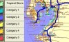
Below is a list of intense hurricanes that have affected U.S. territory. Gilbert is included because of its effects on Texas. Please note that Ivan would rank 5th on this list...
4 PM CDT FAST FACTS ON HURRICANE IVAN:
EXTREMELY DANGEROUS HURRICANE IVAN HEADS TOWARD CAYMANS
POSITION: Latitude 18.2 N, Longitude 79.3W
145 miles ESE of Grand Cayman
MOVEMENT: WNW 9
MAX SUSTAINED WIND: 165 MPH with higher gusts (Category 5)
LOWEST PRESSURE: 914 millibars(mb), 26.99 inches
1988 Hurricane Gilbert - 26.14 in 885.2 mb
1935 Florida Keys - 26.35 in. 892.3 mb
1980 Hurricane Allen - 26.35 in. 899.1 mb
1969 Hurricane Camille - 26.84 in. 908.9 mb
1989 Hurricane Hugo - 27.11 in 918 mb
1992 Hurricane Andrew - 27.23 in 922 mb
1919 Texas Hurricane - 27.37 in. 926.9 mb
1928 Okeechobee, Fl - 27.43 in. 928.9 mb
1960 Hurricane Donna - 27.46 in. 929.9 mb
1900 Galveston Hurricane - 27.49 in. 930.9 mb
1909 Louisiana Hurricane - 27.49 in. 930.9 mb
1915 Louisiana Hurricane - 27.49 in. 930.9 mb
1961 Hurricane Carla - 27.49 in. 930.9 mb


At least 38 dead on the islands.. 
I had the sneaky feeling it was gonna go up the gulf. Are any members in it's predicted path?
UK sends aid to Grenada and Jamaica, but will anybody help Cuba?
Three Royal Navy ships. Two with technicians and medical staff to providing aid to Jamaica, and the other is in Grenada. The government has humanitarian experts on standby. Oxfam (British charity) is flying staff out and said providing drinking water would be the priority.
Quasar1011
King of Sylvania
stormbind said:At least 38 dead on the islands..
Is that total for Jamaica only, or the Caribbean as a whole?
I am in it's possible path.stormbind said:I had the sneaky feeling it was gonna go up the gulf. Are any members in it's predicted path?
 :shakehead: See the bottom of post #57
 on page 3

You can see I am having mixed emotions about all this. Plus, I am kinda sick right now.
 I haven't eaten in 4 days...
AVN
Deity
Quasar1011 said:Is that total for Jamaica only, or the Caribbean as a whole?
AFAIK it's the current figure for the Caribbean as a whole (the figure reported on the Dutch news was 39, but that doesn't differ so much).
Most of them were on Grenada.
Total confirmed losses in the Caribbean, though I think some people are still unaccounted for.Quasar1011 said:Is that total for Jamaica only, or the Caribbean as a whole?
Quasar1011 said:
I did know that

Should have said so. It's just that I kind of assumed that you would assume that I had remembered your post. Oops!
I hope that's coincidental, and not a reaction to big scarey storms coming your way.Quasar1011 said:
ManOfMiracles
Hogwarts Class of '86
Quasar1011
King of Sylvania
Quasar1011
King of Sylvania
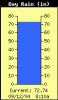
High Temperature
Low Temperature
83.6°F at 7:54a
77.2°F at 3:52a
High Humidity
Low Humidity
98% at 7:35a
74% at 12:08a
High Dewpoint
Low Dewpoint
83.0°F at 7:52a
73.0°F at 12:00a
High Wind Speed
88.0 mph at 7:32a
High Barometer
Low Barometer
998.7 mb at 12:14a
972.4 mb at 7:29a>
High Rain Rate
96.00 in/hr at 2:31a
Quasar: Is this last item accurate? Could be! Look at his rain gage, it shows 72 inches of rain today!!!
Cayman Islands Weather
Low Temperature
83.6°F at 7:54a
77.2°F at 3:52a
High Humidity
Low Humidity
98% at 7:35a
74% at 12:08a
High Dewpoint
Low Dewpoint
83.0°F at 7:52a
73.0°F at 12:00a
High Wind Speed
88.0 mph at 7:32a
High Barometer
Low Barometer
998.7 mb at 12:14a
972.4 mb at 7:29a>
High Rain Rate
96.00 in/hr at 2:31a
Quasar: Is this last item accurate? Could be!
Look at his rain gage, it shows 72 inches of rain today!!!Cayman Islands Weather
Attachments
Bozo Erectus
Master Baker
- Joined
- Jan 22, 2003
- Messages
- 22,389
Possibly a stupid question: Is rain from a hurricane saltier than 'regular' rain?
Marla_Singer
United in diversity
The US won't suffer of Ivan, only Cuba will, and they will be hit hard.
Similar threads
- Replies
- 80
- Views
- 3K