jagdgeschwader
Chieftain
- Joined
- Nov 12, 2014
- Messages
- 20
So I posted this under a different section the other day, but I think this forum is more appropriate. I also made a minor upgrade to the Black Sea, albeit at the cost of the Normandy section of France. However, if you put Cherbourg/Caen on the tile it covers up the blemish. Regardless, the new folder has both files so you can pick which one you like.
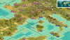
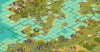
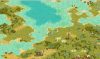
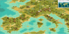
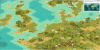
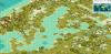
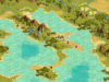
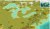
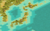
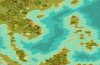
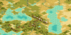
I used the map from from WWII Hinge of Fate scenario as a starting template, so the creator of that map deserves some credit. However, I have drastically modified it to be incredibly visually accurate in terms of geographical terrain pictures, and to do this I developed a new editing technique.
Through a slow, pain-staking process, I individually identified pertinent tile squares and made changes to the LM terrain files to accurately depict the terrain spread of a real world map. Because this has been an ongoing project, when I originally started I didn't necessarily do so in the most organized way, and although I have gotten much better from this standpoint it is still not perfect and they may be a few unnecessarily modified tiles or a few minor discretions. Nevertheless, it's pretty darn good (as you can see from the pictures) and even though this is an ongoing project that is still far from complete, I wanted to go ahead and provide the map to anyone who wants to use it. Note: because I had to edit files, if you want the map in all its glory you will have to load the edited terrain files into the scenario's folder.
Also, this is a WWII oriented map, so it is a little bit Euro-centric. I have made changes to every continent, but the most substantial and detailed are to Europe.
The most heavily modified areas:
Denmark: notice the tile work with lakes in the tundra
Holland: the tiny island change where Amsterdam is
France: Normandy/Pas-de-Calais area
Italy: the boot is 10/10 and the Adriatic Sea around Trieste is spot on
Black Sea: this is a work of art
(
Attachments
-
 Euro-details.png2.7 MB · Views: 478
 -
 Europe1.png3.1 MB · Views: 558
 -
 Europe2.png3.2 MB · Views: 449
 -
 Europe3.png3.3 MB · Views: 442
 -
 Italy-detailed.png2 MB · Views: 452
 -
 Great Lakes.png2.6 MB · Views: 423
 -
 Japan.png2.4 MB · Views: 503
 -
 South Pacific.png2.3 MB · Views: 486
 -
 Black-Caspian (updated).png4.3 MB · Views: 483
Last edited: