Large map of Eurasia

Boggy

Chieftain
Joined
May 25, 2012
Messages
69
Location
Germany


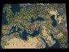
Well, as you can see, it's not actually a map of Eurasia but rather an extended map of Europe. If anyone knows a better name, feel free to suggest it.
This map is based on the Eurasia map in Pie's Ancient Europe, a version of PAE's Europe map extended by Thorgal. That's why India looks rather squeezed in, the original map ends at the Caspian Sea, but I still think that this small India fulfills its purpose.
If I haven't forgotten anything, everything should be done and included: savannah, reefs, one atoll, new resources, natural wonders (I might have excluded Mount Everest as the Himalayas isn't really portrayed accurately due to lack of space, but I've decided to leave it as it is), small adjustments about the terrain, balancing, starting points file. Each leader has his own starting position if necessary, even if they only differ in a few plots.

So... that's it, I'd say.
 

Attachments

  • Eurasia (Large).zip
    36.6 KB · Views: 100
  • Eurasia.jpg
    Eurasia.jpg
    463.8 KB · Views: 1,682
Thanks for this, I'll add it to 1.22. One thing to note for anyone trying this in 1.21.1, is that the Natural Wonder tiles will lack extra tile yield and be unworkable by cities. Extra code is needed to achieve this on random maps, and there is no equivalent code for the real world maps yet. (Main reason I haven't added the Natural Wonders to the existing maps yet). I'll try get it done for 1.22.
 
I've just noticed that BRIAN_BORU is misspelled BRAIN_BORU in the xml file as well as in the large earth map's file from which I copied the file structure.
 
I've just noticed that BRIAN_BORU is misspelled BRAIN_BORU in the xml file as well as in the large earth map's file from which I copied the file structure.

Oops, will fix in both.
 
Sorry, but this map is really out of shape.

Ireland is a bit too northern compared to Great Britain.
The Arab Peninsula is too narrow.
North Eastern Europe is a mess, there should be much more land areas in there.
And Asia Minor's west side looks like it is "falling" southwards.


Western Europe and North Africa are pretty good, though.


I would prefer the original European map, or the Giant Earth Map mode, if you can add it to HR.
 
Jutland (the peninsula part of Denmark) should probably be reduced to 2/3'rds the present size and the land tiles distributed between Zealand and Southern Norway and Sweden.
 
Ireland is a bit too northern compared to Great Britain.

Yeah, that's right.

The Arab Peninsula is too narrow.

That is absolutely intended as it is just a useless pile of desert which rarely contributes to gameplay (especially in PAE where cities cannot be founded on desert). It was made smaller in order to save space.

North Eastern Europe is a mess, there should be much more land areas in there.

What exactly do you mean, too much water? Or is it the Urals?

And Asia Minor's west side looks like it is "falling" southwards.

Sorry, I don't understand that.

Jutland (the peninsula part of Denmark) should probably be reduced to 2/3'rds the present size and the land tiles distributed between Zealand and Southern Norway and Sweden.

Yeah, you're right, the proportion isn't quite accurate.

I would prefer the original European map, or the Giant Earth Map mode, if you can add it to HR.

Which maps do you exactly mean?

If desired, I can change some things about this map and reupload it.
 
I would prefer the original European map, or the Giant Earth Map mode, if you can add it to HR.

The Giant Earth map is just too big for HR. Endless MAFs, if it loads at all. It's 210x90 (18900 tiles), considerably larger than HR's 'Massive' mapsize, which is 160*100 (16000 tiles) and basically the upper limit of what's feasible to play on (and even that can be unstable). There's room in HR for a bigger Earth map as the current Huge one is 124*68 (8432 tiles) but I haven't found the right one yet. There's a real lack of quality Earth maps in that size range, most makers seem to go for sub-10000 tiles or 18000+ tiles. I want something around 12000 tiles.
 
The key issue with the map Boggy provided is that the Mediterranean is skewed. If you look at an atlas, you can see that the northern coast of the Black Sea is roughly the same latitude as the north end of the Adriatic. On this map, the Black Sea is considerably more northerly. This isn't a problem if we consider the map itself to be on an angle, but Europe on this map is drawn as if it were aligned with lines of latitude, resulting in a very shrunken eastern Europe and Western Russia.

However, the map does make more sense if it's considered to capture the curvature of the earth, i.e. we're viewing it from above Western Europe and the further east we look, the more it curves away. Given the way Asia Minor is 'bent' I suspect that this might be what was intended. To make this work better Denmark would need to be angled westward a little and Scandinavia removed in favour of making the northern coast of Eastern Europe further north. India would probably also need to be angled eastward.

All that said, real world maps aren't all about geographical accuracy but also good gameplay. Always a balancing act. I have little experience playing on real world maps so I'm not the best judge of this.
 
Top Bottom