cephalo
Deity
Hi Folks!
This file has been superceded by PerfectWorld2, which you can get from
this thread. The original PerfectWorld map script is available below for those who prefer it to the new one.
This map script for Warlords or BtS and most mods based on Civ4 generates a random, earth-like map, usually with a 'New World' with no starting locations that can only be reached with ocean going technology. Landforms are created using a random heightfield and a plate tectonic scheme. Climate is simulated using the interaction between the landforms and geostrophic winds. Though great pains are taken to semi-accurately simulate landforms and climate, the goal must be to make unpredictible, beautiful looking maps that are fun to play on.
Download the original version of PerfectWorld here from the bottom of this thread.
To use this map, put it in your Civilization 4\PublicMaps folder, not in your My Documents\My Games\Civilization 4\PublicMaps folder.
-- Map Options --
New World Rules:
Start in Old World(Default): Reserves some continents to act as a new world
Start Anywhere: Disables the new world functionality
Pangaea Rules:
Break Pangaeas(Default): Breaks up Pangaeas with a simulated meteor shower (really big meteors)
Allow Pangaeas: Allow pangaeas to exist. Keep in mind that this will likely eliminate any 'New World' as well.
-- Summary of creation process: --
First, a random heightfield is created using midpoint displacement. The resulting altitudes are then modified by a plate tectonics scheme that grows random plates and raises the altitudes near the plate borders to create mountain ranges and island chains.
In generating the plot types from a heightmap, I had found that using peaks for high altitude and land for less altitude created large clusters of peaks, surrounded by a donut of hills, surrounded again by a donut of land. This looked absolutely terrible for Civ, so I made it such that peaks and hills are determined by altitude *differences* rather than by absolute altitude. This approach looks much better and more natural.
The terrain generator gives the other needed visual cues to communicate altitude. Since air temperature gets colder with altitude, the peaks will be plots of ice and tundra, even near the equator, if the altitude is high enough. Prevailing winds, temperature and rainfall are all simulated in the terrain generator. You will notice that the deserts and rainforests are where they should be, as well as rain shadows behind mountain ranges.
Rivers and lakes are also generated from the heightmap and follow accurate drainage paths, although with such a small heightmap some randomness needs to be thrown in to prevent rivers from being merely straight lines.
Map bonuses are placed following the XML Rules but slightly differently than the default implimentation to better accomodate this map script.
I've always felt that the most satisfying civ games are the ones that provide a use for those explorers and caravels. Though the map generator does not explicitly create a 'New World', it will take advantage of any continents that can serve that purpose. No starting locations will be placed on these continents. Therefore, the likelyhood of a significant new world is very high, but not guaranteed. It might also come in the form of multiple smaller 'New Worlds' rather than a large continent.
Enjoy!
Here are some screenshots to illustrate some of the features of PerfectWorld.
Here is a typical example of a standard sized map overview.

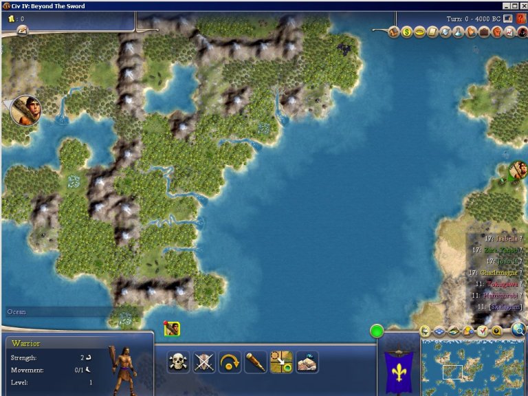
From the same map as above, here is a valley near the equator. Notice how the terrain and features subtly communicate altitude. The hot jungle lowlands are kindof snaking through some higher, and slightly colder, altitudes.
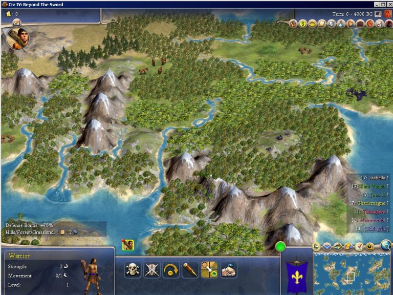
From the same map again, here is a nice coastline. This continent is part of the 'New World' so no starting places were put here.
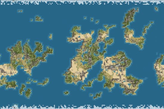
Here is an overview of a huge sized map. It looks like this world found itself on the wrong side of some very large meteors in the distant past. Meteors are used to break up pangaeas which naturally interfere with the new world functionality, but if you happen to like pangaeas, you can turn this option off with the many tuning variables at the beginning of the script.
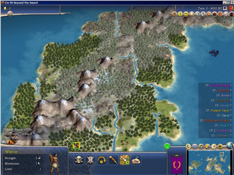
From the huge map now, another example of altitude affecting the terrain. This northern peninsula has a ridge of tundra which, along with the direction of the rivers, helps create an illusion of altitude.
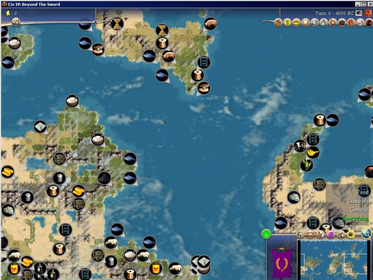
Here is an example on the huge map how resources are placed. I captured a junction of three continents to show that, to encourage trading, different continents have different resource sets. One continent has wheat and pigs, another cows and corn, and the other sheep and rice. These resources are designed in the XML to avoid appearing on the same continent, and this rule is respected when starting plots are normalized also.
Version History
1.13 - Fixed a bug where starting on a goody hut would crash the game. Prevented start plots from being on mountain peaks. Changed an internal distance calculation from a straight line to a path distance, improving start locations somewhat. Created a new tuning variable called DesertLowTemp. Since deserts in civ are intended to be hot deserts, this variable will prevent deserts from appearing near the poles where the desert texture clashes horribly with the tundra texture.
1.12 - Found a small bug in the bonus placer that gave bonuses a minimum of zero, this is why duel size maps were having so much trouble.
1.11 - limited the features mixing with bonuses to forests only. This eliminates certain undesireable effects like floodplains being erased by or coinciding with oil or incense, or corn appearing in jungle.
1.10 - Wrapped all map constants into a class to avoid all those variables being loaded up when PW is not used. Also this makes it a little easier to change them programatically. Added two in-game options, New World Rules and Pangaea Rules. Added a tuning variable that allows bonuses with a tech requirement to co-exist with features, so that the absence of those features does not give away their location.
1.09 - Fixed a starting placement bug introduced in 1.07. Added a tuning variable to turn off 'New world' placement.
1.08 - Removed the hemispheres logic and replaced it with a simulated meteor shower to break up pangeas. Added a tuning variable to allow pangeas.
1.07 - Placing lakes and harbors after river placement was not updating river crossings. Resetting rivers after lake placement should solve this. Fixed a small discrepancy between Python randint and mapRand to make them behave the same way. Bonuses of the same bonus class, when forced to appear on the same continent, were sometimes crowding each other off the map. This was especially problematic on the smaller maps. I added some additional, less restrictive, passes to ensure that every resource has at least one placement unless the random factors decide that none should be placed. Starting plot normalization now will place food if a different bonus can not be used due to lack of food. Changed heightmap generation to more likely create a new world.
1.06 - Overhauled starting positions and resource placement to better suit the peculiarities of PerfectWorld
1.05 - Fixed the Mac bug and the multi-player bug.
1.04a - I had unfairly slandered getMapRand in my comments. I had stated
that the period was shortened unnecessarily, which is not the case.
1.04 - Added an option to use the superior Python random number generator or the getMapRand that civ uses. Made the number of rivers generated tunable. Fixed a bug that prevented floodplains on river corners. Made floodplains in desert tunable.
1.03a - very minor change in hope of finding the source of a multi-player glitch.
1.03 - Improved lake generation. Added tuning variables to control some new features. Fixed some minor bugs involving the Areamap filler and fixed the issue with oasis appearing on lakes. Maps will now report the random seed value that was used to create them in the PythonDbg file, so they can be easily re-created for debugging purposes.
1.02 - Fixed a bug in the way desert placement was calculated. This also required a readjustment of the default values.
1.01 - Added some global tuning variables for easier customization. Fixed some minor bugs that caused deserts to get out of control sometimes.
This file has been superceded by PerfectWorld2, which you can get from
this thread. The original PerfectWorld map script is available below for those who prefer it to the new one.
This map script for Warlords or BtS and most mods based on Civ4 generates a random, earth-like map, usually with a 'New World' with no starting locations that can only be reached with ocean going technology. Landforms are created using a random heightfield and a plate tectonic scheme. Climate is simulated using the interaction between the landforms and geostrophic winds. Though great pains are taken to semi-accurately simulate landforms and climate, the goal must be to make unpredictible, beautiful looking maps that are fun to play on.
Download the original version of PerfectWorld here from the bottom of this thread.
To use this map, put it in your Civilization 4\PublicMaps folder, not in your My Documents\My Games\Civilization 4\PublicMaps folder.
-- Map Options --
New World Rules:
Start in Old World(Default): Reserves some continents to act as a new world
Start Anywhere: Disables the new world functionality
Pangaea Rules:
Break Pangaeas(Default): Breaks up Pangaeas with a simulated meteor shower (really big meteors)
Allow Pangaeas: Allow pangaeas to exist. Keep in mind that this will likely eliminate any 'New World' as well.
-- Summary of creation process: --
First, a random heightfield is created using midpoint displacement. The resulting altitudes are then modified by a plate tectonics scheme that grows random plates and raises the altitudes near the plate borders to create mountain ranges and island chains.
In generating the plot types from a heightmap, I had found that using peaks for high altitude and land for less altitude created large clusters of peaks, surrounded by a donut of hills, surrounded again by a donut of land. This looked absolutely terrible for Civ, so I made it such that peaks and hills are determined by altitude *differences* rather than by absolute altitude. This approach looks much better and more natural.
The terrain generator gives the other needed visual cues to communicate altitude. Since air temperature gets colder with altitude, the peaks will be plots of ice and tundra, even near the equator, if the altitude is high enough. Prevailing winds, temperature and rainfall are all simulated in the terrain generator. You will notice that the deserts and rainforests are where they should be, as well as rain shadows behind mountain ranges.
Rivers and lakes are also generated from the heightmap and follow accurate drainage paths, although with such a small heightmap some randomness needs to be thrown in to prevent rivers from being merely straight lines.
Map bonuses are placed following the XML Rules but slightly differently than the default implimentation to better accomodate this map script.
I've always felt that the most satisfying civ games are the ones that provide a use for those explorers and caravels. Though the map generator does not explicitly create a 'New World', it will take advantage of any continents that can serve that purpose. No starting locations will be placed on these continents. Therefore, the likelyhood of a significant new world is very high, but not guaranteed. It might also come in the form of multiple smaller 'New Worlds' rather than a large continent.
Enjoy!
Here are some screenshots to illustrate some of the features of PerfectWorld.
Here is a typical example of a standard sized map overview.
From the same map as above, here is a valley near the equator. Notice how the terrain and features subtly communicate altitude. The hot jungle lowlands are kindof snaking through some higher, and slightly colder, altitudes.
From the same map again, here is a nice coastline. This continent is part of the 'New World' so no starting places were put here.
Here is an overview of a huge sized map. It looks like this world found itself on the wrong side of some very large meteors in the distant past. Meteors are used to break up pangaeas which naturally interfere with the new world functionality, but if you happen to like pangaeas, you can turn this option off with the many tuning variables at the beginning of the script.
From the huge map now, another example of altitude affecting the terrain. This northern peninsula has a ridge of tundra which, along with the direction of the rivers, helps create an illusion of altitude.
Here is an example on the huge map how resources are placed. I captured a junction of three continents to show that, to encourage trading, different continents have different resource sets. One continent has wheat and pigs, another cows and corn, and the other sheep and rice. These resources are designed in the XML to avoid appearing on the same continent, and this rule is respected when starting plots are normalized also.
Version History
1.13 - Fixed a bug where starting on a goody hut would crash the game. Prevented start plots from being on mountain peaks. Changed an internal distance calculation from a straight line to a path distance, improving start locations somewhat. Created a new tuning variable called DesertLowTemp. Since deserts in civ are intended to be hot deserts, this variable will prevent deserts from appearing near the poles where the desert texture clashes horribly with the tundra texture.
1.12 - Found a small bug in the bonus placer that gave bonuses a minimum of zero, this is why duel size maps were having so much trouble.
1.11 - limited the features mixing with bonuses to forests only. This eliminates certain undesireable effects like floodplains being erased by or coinciding with oil or incense, or corn appearing in jungle.
1.10 - Wrapped all map constants into a class to avoid all those variables being loaded up when PW is not used. Also this makes it a little easier to change them programatically. Added two in-game options, New World Rules and Pangaea Rules. Added a tuning variable that allows bonuses with a tech requirement to co-exist with features, so that the absence of those features does not give away their location.
1.09 - Fixed a starting placement bug introduced in 1.07. Added a tuning variable to turn off 'New world' placement.
1.08 - Removed the hemispheres logic and replaced it with a simulated meteor shower to break up pangeas. Added a tuning variable to allow pangeas.
1.07 - Placing lakes and harbors after river placement was not updating river crossings. Resetting rivers after lake placement should solve this. Fixed a small discrepancy between Python randint and mapRand to make them behave the same way. Bonuses of the same bonus class, when forced to appear on the same continent, were sometimes crowding each other off the map. This was especially problematic on the smaller maps. I added some additional, less restrictive, passes to ensure that every resource has at least one placement unless the random factors decide that none should be placed. Starting plot normalization now will place food if a different bonus can not be used due to lack of food. Changed heightmap generation to more likely create a new world.
1.06 - Overhauled starting positions and resource placement to better suit the peculiarities of PerfectWorld
1.05 - Fixed the Mac bug and the multi-player bug.
1.04a - I had unfairly slandered getMapRand in my comments. I had stated
that the period was shortened unnecessarily, which is not the case.
1.04 - Added an option to use the superior Python random number generator or the getMapRand that civ uses. Made the number of rivers generated tunable. Fixed a bug that prevented floodplains on river corners. Made floodplains in desert tunable.
1.03a - very minor change in hope of finding the source of a multi-player glitch.
1.03 - Improved lake generation. Added tuning variables to control some new features. Fixed some minor bugs involving the Areamap filler and fixed the issue with oasis appearing on lakes. Maps will now report the random seed value that was used to create them in the PythonDbg file, so they can be easily re-created for debugging purposes.
1.02 - Fixed a bug in the way desert placement was calculated. This also required a readjustment of the default values.
1.01 - Added some global tuning variables for easier customization. Fixed some minor bugs that caused deserts to get out of control sometimes.
Attachments
-
 Standard Overview 2.jpg48.7 KB · Views: 1,466
 -
 Standard Overview 3.jpg49 KB · Views: 1,536
 -
 Standard Overview.jpg50 KB · Views: 36,169
 -
 Standard Jungle Valley.jpg141.9 KB · Views: 36,478
 -
 Standard Coastline.jpg108 KB · Views: 36,425
 -
 Huge Resources.jpg101.8 KB · Views: 35,504
 -
 Huge Altitude.jpg119.5 KB · Views: 36,714
 -
 Huge Overview.jpg44.4 KB · Views: 36,963
 -
PerfectWorld.zip39.2 KB · Views: 4,090

 The only place where I think it needs work is the shape of the continents - they're a bit web-like and all seem to snake together. Also, having Sahara-like deserts that don't fade into grassland after three tiles is wonderful, but some of these deserts might be a little *too* big. If the way they're generated is based on the shape of the continent (this is great!), having some different options for continent generation might be helpful. Nercury's Planet Generator script does a good job of creating realistically-formed continents - if you could incorporate that with your wonderful climate generator code the script would be, well, perfect. Good work!
 I tweaked and tweaked until most of the maps were balanced lol. If, for example, all the continents end up in the rain zones at the equator and +/- 60 degrees, then even now the world is mostly rainforest. It's a big 'what if' scenario.


