New Map 1.18 City Name Suggestions

Leoreth

Blue Period
Moderator
Joined
Aug 23, 2009
Messages
37,053
Location
東京藝術大学
I have created Google sheet that I intend to keep in sync with the city name map currently used by the mod: DoC 1.18 Cities

In particular, I want to enable everyone to take a look at the map and make suggestions. The current state is already extremely good, especially taking the extensive comments with alternate names into account, but I am sure there is more room for improvement. Credit in particular to @LacsiraxAriscal and @Krieger-FS for their work on this. I have already made minor changes, in particular ensuring my preferred transliterations for Russian, Chinese, and Japanese, but other than that it is mostly unchanged.

You can look at the shared sheet but I do not want to enable comments or suggestions because that would make it difficult to keep it in sync with the mod state.

Instead, please make a personal copy of the sheet, make the edits there, and link the modified sheet here. For ease of editing, I would like to ask you to highlight modified names in bold and italics. Alternatively, if you have access to the map branch, you can also make suggestions in game by placing a landmark sign on the respective tile. If you prefer, screenshotting the ingame map and editing names on top of the tiles also works. The important part is that I can clearly tell which tiles are intended to change.

Spoiler Examples for valid suggestions :
CityNameProposal.png
Civ4ScreenShot0397.JPG


Things that definitely need to be revised: the city name map has not been updated since the Nile has been moved 1W, and some of the Saharan peaks have been moved. So if someone wants to adjust the city name map for that, it would be appreciated.
 
Copying the map doesn't seem to be allowed.

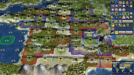
I got my old France map back and compared with the current state of the spreadsheet (the screenshot incorporates some minor changes to resource placements and rivers but those aren't immediately relevant to this thread - outside of that the terrain hasn't changed in the Map Overview thread). Names that differ on the spreadsheet are below in white. The two city name grids aren't too dissimilar, though the placement of Paris is a bit odd (it depends on how much you want France to extend to the northeast I suppose).

france city names.png
 
Last edited:
My bad, copy/download should now be possible on the sheet.

I noticed Paris as well and agree it should be 1S of the wheat.
 
After completing my suggestions for Africa, I was working on something easier by making city name suggestions for Portugal and Spain. So, to complete all my suggestions for the Iberian Peninsula, here goes the last suggestions for it (including Celtic and Ancient Iberian towns!) on the sheet.
 

Attachments

  • DoC 1.18 Cities.xlsx
    237.4 KB · Views: 74
I'm looking at that map. Just some small suggestion about Mexico, the tile west of Chihuahua (or 5N,1W of Tenochtitlan/Mexico City) could be Cuauhtemoc, as well as the one southwest occupied by Parral. South of Chihuahua (two north of Durango, or 4N,2W of Tenochtitlan) could be Jimenez or Delicias.
 
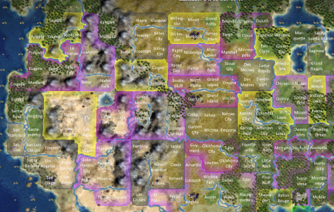
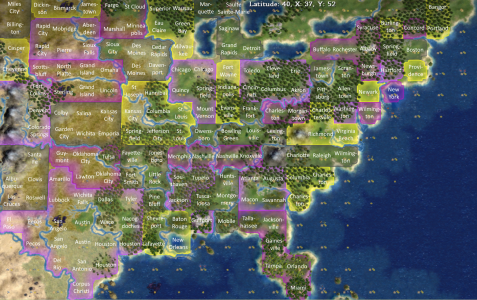
I retouched the American names for the contiguous United States (didn't touch the notes for other languages) and added borders for the states.

It's possible though that some cities will share a name. Should they be replaced as much as possible (for example Augusta, Maine instead of Portland, Maine), or should they receive a suffix (Portland, ME vs Portland, OR) if they're both present on the map?
 

Attachments

  • DoC 1.18 Cities(1).xlsx
    177.4 KB · Views: 46
There is no need to differentiate duplicate names anymore. Under the new system, the name of a city will be fully determined by the tile it is on, so there is no need to do that anymore.
 
The Ohio-Pennsylvania-New York tristate area is a little wacky. As a native of Erie, Pennsylvania I appreciate its inclusion, but am greatly offended that it apparently falls within Ohio!
 
Yes, I didn't correct the Erie tile from the original map, I guess it should be Cleveland or Akron, and the Jamestown tile 1E of it should be Erie.

The Great Lakes are a bit stretched out east-west so Ohio ends up bigger (it should be around 4 tiles instead of 6). I'm not sure how to adress this though, Indiana is already disaligned from Lake Michigan and New York State already covers more tiles than it should. I could see giving two Ohio tiles to Pennsylvania though, but I gave these tiles to Ohio based on the position of the river.
 
Yeah, that makes sense. I noticed the river thing, too - I was originally going to suggest having Pittsburgh replace Akron (since Pittsburgh is 100% directly south of Erie) and put Harrisburg or something where Pittsburgh is, but then the Ohio River would go to Pittsburgh's south, which isn't really accurate.

Also, not having Philadelphia seems like a big oversight, although I guess I don't know where I would put it. Maybe replace Allentown?
 
I retouched the American names for the contiguous United States (didn't touch the notes for other languages) and added borders for the states.

It's possible though that some cities will share a name. Should they be replaced as much as possible (for example Augusta, Maine instead of Portland, Maine), or should they receive a suffix (Portland, ME vs Portland, OR) if they're both present on the map?
I'm not sure how this is an improvement over the doc linked in Leoreth's original post. There are a lot of tiles that had unique city names that have been changed to duplicates of other cities, like changing Cape Girardeau to a second Saint Louis or Topeka to another Kansas City. How is this better?
 
Sandomierz should be Kielce in modern times, Sandomierz isn't really a relevant city at all anymore.

Also, what is the rationale for including Medvegalis? I remember that I looked it up before since it isn't a name I know, nor does it stylistically fit into the Polish names, which are typically in Polish, but Medvegalis has no Polish name. From what I found, it's an early Lithuanian fort in the area, but did not appear to be particularly noteworthy. Personally, I'd just have Memel/Klaipeda from the start instead.
 
Last edited:
Shape of states is ok. One small meta-level suggestion is that I think it's better (one man's opinion, not fact) to have the big cities fit together on the map than have perfect geography of every state.

Example: New York is only 2 tiles from DC. Good geography but hard to see how NYC becomes NYC this way.
 
Last edited:
For the city tile that becomes Alexandria, I just discovered that there was a much earlier Egyptian city on the same site: Thonis-Heracleion. I'm honestly not sure what to make of it in terms of the city names map, since it's basically equidistant between Rasheed (Rosetta) and Rhakotis (Alexandria), though as far as I can tell it was located on the west-most branch of the Nile delta at the time, making it equivalent to Alexandria's placement even though the Nile delta had changed by the time Alexander founded the city. Either way, 'Thonis' as the original Egyptian name should definitely be included on one of those tiles.
 
Top Bottom