You are using an out of date browser. It may not display this or other websites correctly.
You should upgrade or use an alternative browser.
You should upgrade or use an alternative browser.
T.S. Ike
- Thread starter Quasar1011
- Start date

holiday_hawk
King
Glad I live in the north.
Bigfoot3814
Deity
Why can't they leave Nawlins alone. 
BrendanM
Prince
Why can't they leave Nawlins alone.
Centuries of debauchery.
Miles Teg
Nuclear Powered Mentat
Could you tell my why you don't like Ike?
Could you tell my why you don't like Ike?
I like Ike.
Evie
Pronounced like Eevee
Heh.
That storm still has a week to decide to go hit Haiti instead, or to recurve to sea and spin fishes, or whatever. 5-days predictions are notoriously inaccurate.
It's way, way, way too early to even start acting like we have a clue what this will wind up being.
That storm still has a week to decide to go hit Haiti instead, or to recurve to sea and spin fishes, or whatever. 5-days predictions are notoriously inaccurate.
It's way, way, way too early to even start acting like we have a clue what this will wind up being.
Trajan12
Deity
Is it evil that I chuckled a little at the thought of NOers returning to their homes and breathing a sigh of relief only to be ravaged by Ike?
Quasar1011
King of Sylvania
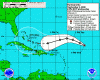
Ike has just been upgraded to a category 3 hurricane. South Florida needs to watch this one very closely, as it is not projected to lose strength over the next 5 days! -Q
------------------------------------------
HURRICANE IKE SPECIAL DISCUSSION NUMBER 11
NWS TPC/NATIONAL HURRICANE CENTER MIAMI FL AL092008
800 PM EDT WED SEP 03 2008
THIS SPECIAL ADVISORY IS TO UPDATE THE INTENSITY OF IKE. SATELLITE
IMAGES INDICATE THAT IKE HAS BEEN RAPIDLY INTENSIFYING AND HAS
DEVELOPED AN EYE THAT IS SURROUNDED BY VERY COLD CLOUD TOPS.
SPECIAL CLASSIFICATION PERFORMED BY TAFB AND SAB BOTH YIELD
T-NUMBERS OF 5.5. IN FACT...THE DATA T-NUMBERS FROM BOTH AGENCIES
WERE SLIGHTLY HIGHER AND RAW ADT ESTIMATES FROM UW-CIMSS HAVE BEEN RUNNING BETWEEN ABOUT 6.0-6.5 DURING THE LAST 2-3 HOURS. THE INITIAL INTENSITY IS THEREFORE INCREASED TO 100 KT...MAKING IKE A
CATEGORY THREE HURRICANE. THE INTENSITY FORECAST HAS BEEN RAISED THROUGHOUT THE PERIOD...BUT AS WITH ALL INTENSE HURRICANES...SOME FLUCTUATIONS IN INTENSITY SHOULD BE EXPECTED.
NO CHANGES WERE MADE TO THE TRACK FORECAST...AND ONLY MINOR CHANGES WERE REQUIRED TO THE WIND RADII.
FORECAST POSITIONS AND MAX WINDS
INITIAL 04/0000Z 21.7N 53.2W 100 KT
12HR VT 04/0600Z 22.6N 55.1W 110 KT
24HR VT 04/1800Z 23.8N 57.9W 115 KT
36HR VT 05/0600Z 24.3N 60.4W 115 KT
48HR VT 05/1800Z 23.8N 63.1W 110 KT
72HR VT 06/1800Z 22.5N 68.0W 110 KT
96HR VT 07/1800Z 22.5N 72.0W 115 KT
120HR VT 08/1800Z 23.5N 76.0W 115 KT
$$
FORECASTER BROWN
Attachments
Poor Bahamas. Back to back storms.
JtheJackal
Emperor
- Joined
- Jul 25, 2002
- Messages
- 1,521
This is why I supported Adlai Stevenson
Ansar
Détente avec l'été
I don't like Ike.
QuoVadisNation
keeping your angel alive
While I sympathize with all the peoples living in Florida and Puerto Rica (but not Cuba) on account of them being slightly bothered by Ike and Hanna, I'm just glad that there's no more coming to New Orleans. Hopefully..
silver 2039
Deity
- Joined
- Jul 26, 2003
- Messages
- 16,208
Those parts are really getting raped aren't they?
Evie
Pronounced like Eevee
While I sympathize with all the peoples living in Florida and Puerto Rica (but not Cuba) on account of them being slightly bothered by Ike and Hanna, I'm just glad that there's no more coming to New Orleans. Hopefully..
"Hopefully" being the operative keyword.
Ike is heading pretty much toward the Katrina/Rita expressway.

warpus
In pork I trust
While I sympathize with all the peoples living in Florida and Puerto Rica (but not Cuba) on account of them being slightly bothered by Ike and Hanna, I'm just glad that there's no more coming to New Orleans. Hopefully..
Hey, what the hell do you have against cubans??? Take that back< NOW
Evie
Pronounced like Eevee
Heh.
That storm still has a week to decide to go hit Haiti instead, or to recurve to sea and spin fishes, or whatever. 5-days predictions are notoriously inaccurate.
It's way, way, way too early to even start acting like we have a clue what this will wind up being.
Ok, *now* we can start getting worried. That thing doesn't seem interested in changing track much, and does seem interested in being a monster-size hurricane.
Quasar1011
King of Sylvania
Still 5 days out, but we could be seeing an evacuation of southern Florida in a few days, if Ike stays on course. It is projected to weaken, due to moving into some shear aloft, and moving over cooler water upwelled from Hurricane/TS Hanna; but to re-strengthen after that.

Quasar1011
King of Sylvania
Hanna is still ragged and disorganized; Ike has a well-defined eye, even if the storm is a bit asymmetrical.

Similar threads
- Replies
- 11
- Views
- 438
- Replies
- 119
- Views
- 5K
- Replies
- 450
- Views
- 13K