- Home
- Forums
- OUR ARCHIVES
- List of Archived Forums
- Civilization IV Archives
- Civ4 - Multi-Team Demogame
- Team Loco
You are using an out of date browser. It may not display this or other websites correctly.
You should upgrade or use an alternative browser.
You should upgrade or use an alternative browser.
Turns 11 - 20: Summary Thread
- Thread starter koondrad
- Start date


King Flevance
Deity
Suggesting that poduction now be switched off the plains hill for a +1 food to be thrown into the production for the worker.
Karl Townsend
Prince
- Joined
- Dec 27, 2005
- Messages
- 429
yea casue then deli will grow a little bit faster but it wont when its prducing as worker
ranathari
Glasses
- Joined
- Aug 19, 2005
- Messages
- 178
To rephrase: cities don't grow when they're producing workers or settler so there's no point in trying to maximise growth right now.
What Flevance meant was that we should stop working the plains and start working the hills to get extra hammers to get that worker out of the door faster.
What Flevance meant was that we should stop working the plains and start working the hills to get extra hammers to get that worker out of the door faster.
King Flevance
Deity
Actually, I mean that by working the corn and the wooded grassland we should get +1 production on the worker.
As is we have 2 population eating 4/5 food total. Pulling 4 hammers and 1 food going towards production of the worker. If we switch to the wooded grassland it will change to 4 hammers + 2 food being allocated to build the worker. This may complete the worker in 12 turns instead of 15. I believe the 4th hammer we are getting is the other food being converted to a hammer. If not, anyone know how we are getting 4 hammers right now?
As is we have 2 population eating 4/5 food total. Pulling 4 hammers and 1 food going towards production of the worker. If we switch to the wooded grassland it will change to 4 hammers + 2 food being allocated to build the worker. This may complete the worker in 12 turns instead of 15. I believe the 4th hammer we are getting is the other food being converted to a hammer. If not, anyone know how we are getting 4 hammers right now?
Emp. Killyouall
EVIL Emperor
Already for the second city, if no one has mentioned it yet, a great place would be up north and slightly to the east. since I see everything from the screenies, I can't plot out the best place, but it will get 3? rescources.
koondrad
Prince
- Joined
- Mar 5, 2005
- Messages
- 492
Emp. Killyouall said:Already for the second city, if no one has mentioned it yet, a great place would be up north and slightly to the east. since I see everything from the screenies, I can't plot out the best place, but it will get 3? rescources.
Break out MS paint and draw us some fat crosses.

@KF - You're quite right - that would indeed help us with the worker. I'll sort it next turn.
The maths behind it:
A Fast Worker costs 60 shields (fake edit: hammers).
Currently we're getting 5 food + 3 hammers. The screenshot shows us getting 4 at the top but that it because of 1 hammer overflow.
The pop. eats 4 food a turn, leaving us with 1 excess food which actually can be treated like a hammer in
![[civ4]](/images/smilies/civ4.gif "Civ4 [civ4]") .
.60 hammers/ (1 food + 3 hammers) of course gives us our 15 turns.
If we change back to working the forest we'll get 7 food and 2 hammers.
60 hammers/ (3 food + 2 hammers) = 12 turns.
So yeah this should help and the same thing applies to Settlers. Unrfortunately, it stunts our growth.

Cheers,
Karl Townsend
Prince
- Joined
- Dec 27, 2005
- Messages
- 429
im sure gonna go crazy if we lose casue this is so good talking about evry move in depth
Sirian
Designer, Mohawk Games
koondrad said:Break out MS paint and draw us some fat crosses.
Don't forget the big colored dots. Dotmap(TM), by Sirian. ... Make use of the power of the Pink Dot(TM) if you know what's good for you.

- Sirian
Emp. Killyouall
EVIL Emperor
As I am supposed to create a dotmap... someone should probably put the information on the gmail account where I can find it. 
koondrad
Prince
- Joined
- Mar 5, 2005
- Messages
- 492
Emp. Killyouall said:As I am supposed to create a dotmap... someone should probably put the information on the gmail account where I can find it.
Don't worry man, I'll get you some nice screenshots this turn.
Cheers,
koondrad
Prince
- Joined
- Mar 5, 2005
- Messages
- 492
Warrior moved E.
Delhi renamed to Short Line.
Short Line:

Goody hut:

For Emp. :

Cheers,
- Spotted goody hut!
Warrior2 moved W.Delhi renamed to Short Line.
- Changed worked hill tile to forest tile.
- 11 turns until Fast Worker is completed.
- 20 turns prijected for a Settler/
Short Line:

Goody hut:

For Emp. :

Cheers,
Emp. Killyouall
EVIL Emperor
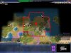
Ok, I have made 3 (yes, laugh all you want, image xpert 200 sucks) dotmaps considering what we want to do. The first one is a city site with less ocean but more chance for production, the second moved up a square to be moved out of Short Line's way. The third one I haven't created boundaries, and is for if we want a specialized city with 2 gold resources seperate from the fish and wheat resources. TY Koondrad!
Let me know if the stupid screenies dont show the red lines... For some reason I could upload only one, the others it says it is the same file...
EDIT damn. Does anyone know how to get around that? I will try different things right now...
Let me know if the stupid screenies dont show the red lines... For some reason I could upload only one, the others it says it is the same file...
EDIT damn. Does anyone know how to get around that? I will try different things right now...
Attachments

Emp. Killyouall
EVIL Emperor

King Flevance
Deity
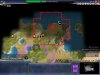
Actually Emp.'s 3rd pic made me realize possibly going this route as to not split up the gold. (See picture)
If we were to go this route though, I would suggest making the research city first out of these two as it will get us ahead in tech. Although, I know right now we are trying to find a spot for the Pyramids. Hopefully there is stone somewhere.
If we were to go this route though, I would suggest making the research city first out of these two as it will get us ahead in tech. Although, I know right now we are trying to find a spot for the Pyramids. Hopefully there is stone somewhere.

koondrad
Prince
- Joined
- Mar 5, 2005
- Messages
- 492
Sites listed in order of suggestion with the only improvement being the city itself unless otherwise stated -
Site 1:
With mined hills:
My preference for the cities would be the pair idea, as suggested by Emp and drawn by KF.
Site 1:
27 Food
15 Hammers
12 Gold
With mined hills:
+8 Hammers
+5 Gold
Umm, so yeah, I gave up after getting one done. It's really tedious to do so I'll remember to turn on the yield icons for the screenshots next time.
My preference for the cities would be the pair idea, as suggested by Emp and drawn by KF.
Similar threads
- Replies
- 11
- Views
- 986
- Replies
- 106
- Views
- 5K
- Replies
- 88
- Views
- 3K