An Ancient India Scenario

Thanks, Takhi, for the executive summary. I'd only add that resources associated with a particular religion may be in more than one region. The resources would be localized, but not necessarily to a single locale. For example, Krsna in the North and Rama in the South are both associated with important Vaishnava sites. A single "avatar" resource would both allow and limit building important temples to historical pilgrimage sites scattered across the whole subcontinent.

The railroad idea is interesting. Units would use it. But if workers can't build them, and they only parallel rivers, that is explainable in the gameworld context. Caveat: cities built along the railroads can also connect to road networks. Perhaps leading to unintended ports having access to the resource(s).

Further thoughts on "religious" resources: wouldn't need to sacrifice too many slots to get a lot of combinations - even without involving other types of strategic resources such as marble. For example say there are 3 resources - "avatar", "relic", and "pilgrimage". That's 3 x 2 or 6 combinations. But each resource can be required to be local or networked independently of the other. If I have my math straight it's now (3x2)x(2x2) or 24 combinations. That's 24 distinct buildable items delimited by 3 resources. Adding the evolving techs and the need for pre-existing builds makes that number even larger. The three example resources are independent of the specific South Asian religions. Meaning that the same resources can be requirements for buildables particular to any religion. No need for Buddhist resources separate from Jain resources.
 
Gentlemen:

I very much like your thoughts on religious resources and the concept of localized resources.

I'm not sold on the invisible railroad idea yet. I don't think landlocked civs should be able to access a port except through conquest. At game start there are only three regular roads. One leads from the western edge of the map to Alexander's eastern conquests. The second, known as the Uttarapatha, the Northern Route, parallels the Ganges from the vicinity of Maghada and travels northwest to Taxila and then north to connect with the silk route off map. The third, called the Daksinapatha or Southern Route, led out of Maghada and travelled east to the city of Uljain in Avanti.

Great wonders (continued): We can have a plethora of great wonders (see Hegemon) or just a few (see Rood and Dragon). We can parallel the existing Conquests great wonders in terms of outcomes, or, we can create great wonders with entirely new outcomes, or, we can combine the two.

Here's another possible wonder for consideration:
Arthasastra, the Sanskrit manual of statecraft.

Resources:
Grey ware pottery
Black-and-red ware pottery

Buildings:
Ritual Bath House
Jainist Monastery
Buddhist Monastery
 
Religions:

Yes, I'm loving the localised religions resource idea and Blue Monkey is dead right about getting many options out of just a few of these. I really like the idea from Takhsis about religion being indigenous to a region and then also spreading through the trade network. When you throw in the 'required in city radius' flagbox for improvements, you can scale up or down the levels of localised piety and cultural flavours very nicely.

With this in mind, you needn't necessarily have a dramatic 'religious conversion' moment for a civ (except perhaps in the case of the Mauryans late game). You can instead allow certain religious improvements to be built as those religious resources enter the trade network, with a civ being able to build improvements from a variety of religions at the same time. Probably quite realistic to how things went at the time. This can be controlled further by the 'required government' flagbox for improvements, allowing a civ to make a more or less dramatic conversion.

I would still counsel that you use Taxila and the civ you put up in the Himalayas as two beacons of Buddhism, influencing the others and especially Mauryans in the late game. How you do that can be decided. But this would be a good representation of things as they were, as well as help to make those civs more relevant, rather than just fillers. (I still feel Nepal in Rise & Fall of the Mughals was a bit too much of a token filler).

Wonders:

I'm so glad to see Arthashastra suggested as a wonder. I'm big on books and written works being wonders - they are! And this one is truly significant; for this mod in particular (Kautilya aka Chanakya was a very influential figure in Chandragupta's life, almost a Svengali figure. I'm sure you'll find lots on him), for statecraft in India in general, and indeed for statecraft beyond India. I'm still none the wiser whether the Persian version, the Shahnama, is derived from it or vice versa, or whatever. But there's clearly a parallel. These treaties on kingship and statecraft were very significant in their times, as well as being a treasured source for later historians.

Awesome list of wonder suggestions from The Blue Monkey there. I won't muddy the waters by suggesting yet more. Maybe later. On wonders approach options, I don't have any answers just yet, at least not until the civ list and features are decided upon. But I will share some thoughts I had in going for the plethora option in Hegemon to help you decide. The reasons why there are many wonders in Hegemon are:

(a) There are 31 civs in that scenario. This meant two things. Firstly, there are that many more civs that can be denied the benefits of a specific wonder, so I thought it a good idea to make available those benefits (eg. barracks in every city) through a few other wonders. With a few heavy warmongers around in that scenario, it was too painful to let only one get the barracks in every city benefits. Secondly, I felt I needed to use them for flavouring the history, culture and abilities of the civs to help try and create some distinction between so many civs (hence 31 of those being unique wonders).
(b) Some wonder benefits are cumulative and I needed that. For example, given the Aegean Sea setting in Hegemon, cumulative increased ship movement benefits was one important feature that I wanted certains civs (especially Athens) to be able to exploit. I suspect you might not have any such needs for this scenario, but then again you might.
(c) I used the Olympian Gods Temples as my only nod to religion in that mod. Seems you've got an alternative in resources here though.
(d) The vanilla array of wonders and benfits is good. But I don't see why it's the only way of doing things. I don't even play the vanilla version of the game anymore, just mods and scenarios. So I've quite forgotten the original ones and I don't see why sticking to them matter anyway. Do what's appropriate for your needs.

Also, I could get away with many wonders in Hegemon because I'm not operating a culture victory in there. I suspect Plotinus didn't put many in Rood & Dragon because he's got the Irish threatening a culture victory in his scenario. Having many wonders around would upset that dynamic, though you can of course have wonders that don't produce any culture.

Resources:

I really like the iron resource leading onto wootz production option from Blue Monkey. I didn't know anything about this till he posted, but I do recall ironworking techniques in the area around modern day Delhi being something of a big thing and quite ahead of its time, especially iron pillars that were made there around this period. If you go for this, make sure you've got some serious ironworking options in that area.

On elephants, I think you should have a few different types of this resource around. At least two. Giving them just to Kalinga would be a mistake I think. There are many other ways of making them powerful and it would be a tragedy not to have others with elephants in the game. Remember that King Poros scared the chutney out of Alexander's troops with them and that Chandragupta came to a deal with Alexander which saw Chandragupta giving him 500 elephants in a peace treaty (though they did their service, he cunningly gave him old ones that soon died). On a recent trip to India, I visited a Mahut camp and got some good beef on elephants. They are very significant to the region of Kerala. The elephants there are apparently tougher and more hard working than others. If memory serves well, the mahut I chatted with said that the two best elephants in India come from Kerala and the area around Bihar. So why not go for two or more different types of elephant resource? And why not do the same with horses (with better ones available in the west and lesser in the Ganges and Deccan)?
 
Ram:

Resources:

Elephants: You have crystallized my thoughts on elephants. I was thinking (nebulously) about having more than one kind of elephant. We can put the "super" elephants in Kalinga - allows you to build a more powerful elephant unit. Did they have elephant chariots?

Buddhist Relics?: Build an X and Buddhist relics become available for trading with those who don't have them. Having a Buddhist relic allows you to do Y. Perhaps you need the Parinirvana wonder (see below) in order to see the relics. You transport the relic (by Buddhist monk?) to a Z building (stupa? monastery?) and you get some kind of payoff.

Timber: Very important to shipbuilders and catapult builders.

Wonders:

The Four Noble Truths
The Eightfold Path
The Mahabharata (too old for this scenario?)
The Ramayana (likewise?)
The Triple Gems of Jainism
Buddhist Council
Four Buddhist Holy Sites:
Parinirvana of the Buddha (pre-placed in Kusinara)
Bodh Gaya (pre-placed in Gaya)
Deer Park (pre-placed in Sarnath)
Birthplace of the Buddha (pre-placed in Lumbini)
Jainist Council

Civs:Taxila is very important and is on the list. I think most of the four Buddhist holy sites are in Nepal, which makes that area attractive. It also makes those civs powerful in a cultural sense.

Techs: One thing I've learned is that the Indian civs of this era were much more advanced than I had ever considered. What this means is that a lot of the "typical" techs you find in CivIII scenarios will have already been discovered. Also, they were great sailors so there's no need for a tech (or wonder) that let's you sail beyond sight of land.

Possible tech:
Wet rice cultivation

Religions: Both Buddhism and Jainism seem to have identifiable starting localities. Hinduism (sorry Blue) seems to be the default. How do we get the first two to flow through the latter as Tak suggests? Particularly, when we have someone like Ashoka generally allowing "freedom of religion."

All in all, I think things are shaping up nicely.
 
Resources:

Elephant Chariots? Sounds scary! And a bit too slow. I wouldn't want to ride in one on a battlefield - wouldn't want to be on a battlefield anyway!

I reckon good locations for elephants would be:

- Kalinga (super ones, complete with superman underpants)
- Kerala (different kind of super one, perhaps second grade or on a par, but different)
- Bihar (third grade)
- A couple of spots in the Deccan (same third grade as Bihar), something in central Andra Pradesh area and also north west Deccan (King Poros needs to have some kind of access to them, after all)

Buddhist Relics sounds spot on. Not sure whether you mean them to be flag/treasure units auto-produced by wonders and improvements or resources though, or maybe both. The thing to be careful of with flag/treasures is - and I may be mistaken here - you can only get reward for them by delivering them to your capital (capture the princess) or a victory point location (reverse capture flag). If you have to deliver them to someone else's capital / VPL, there's no way of doing this without being at war with them. Even if the VPL isn't in a city of theirs, they will place units on it to collect the VPs, which again means war to deliver them.

Yes, timber, of course!

Wonders:

Those are all sounding good to me. But I still think I'll lay off commenting here. I don't want to swamp with too many options, have said some already and think you need to get the civ list and some kind of tech tree and game dynamics fixed up first.

Techs:

Yeah, erm, no real ideas on this at present. Haven't really thought about it. It'd definitely be wise and appropriate to have a few different agricultural type ones in there: Wet rice cultivation sounds good, some kind of spice farming (for the southern guys to exploit spices down there), tea farming, coffee plantations, pearl fishing.

Crafting and metal working (as outlined by Blue Monkey) techs would be sensible too I guess. Crafting would include/cover stuff like: Marble carving for statues and temples, cotton working, gold mining (gotta have some major gold working going on as India was in ancient times and always has been famed for this), bronze statue casting, cave painting a la Ajanta and Ellora, weaving for tribal areas.

Military techs it sounds like Blue Monkey knows a lot about this already.

Religious techs should be big of course and you've got lots of things to base these on already.

Literary techs to cover Buddhist texts, Sangam era poetry and poet 'conventions'.

Statecraft techs for Arthashastra and courthouses, lion columns etc.

Civs:

Come on man, quite teasing and feed us the civ list as it looks so far.
 
Civilizations v4.0

Format: Civ - Leader - Capital city

Himalayan Culture Group
1. Kirat [Nepal] - Raja Sthunko – Matatirtha [modern day Matatirtha]
2. Shakya [Nepal] –Raja Suddhodana – Kapilvastu [modern day Lumbini] birthplace of the Buddha.
3. Malla [Nepal] –Raja Kushinagar - Kusinagara [Modern day Kasia]
4. Monyul [Siliguri Corridor] – Raja Suparua – Pragiyotishpura [modern day Guwahati]
5. Zhang Zhung [Tibet] – Raja Ligmikya - Khyunglung

Central Culture Group
6. Magadha/Maurya - Raja Ashoka – Rajagriha [modern day Rajgir]
7. Gangarashtra [Vanga] – Raja Dhanadhana – Ganga [modern day Chandraketurgh]
8. Nanda - Raja Mahapadma – Pataliputra [modern day Patna]
9. Kalinga - Raja Kharavela – Tosali [modern day Bubaneshwar]?
10. Kosala – Raja Vidudabha – Shravasti [near modern day Balumpur]
11. Avanti – Raja Pradyota - Ujjain [modern day Ujjain]

Western Culture Group
12. Pauravas - Raja Porus – Purushapura [modern day Peshawar]
13. Gandhara – Raja Ambhik – Takshashila [modern day Taxila]
14. Surashtra – Raja Sah – Vododara [modern day Baroda]

Southern Culture Group
15. Vidarbha – Raja Bhimasena – Kundinapur [modern day Gondia]
16. Cholas – Raja Karakala – Puhar [modern day Puhar]
17. Pandyas – Raja Netunchezhiyan – Madura [modern day Madurai]
18. Chera – Raja Chenkuttavan – Vanchi [probably vicinity modern day Thodupuzha]
19. Anuradhapura [Ceylon] - Raja Devanampiya Tissa - Anuradhapura

Yavana Culture Group
20. Macedonia - King Sikander – Macedonian Base
21. Bactria – Satrap Diodotus – Bahli [modern day Balkh]
22. Kamboja - Consul Kurosh – Simhapura [modern day Rajauri]
23. Arachosia – Satrap Barsaentes - Kapisakaniš [later Alexandria Arachosia, now modern day Kandahar]
24. Gedrosia – Satrap Karkis - Pura [modern day Bampur]
 
Looking very good!

I found some leaders that would fill some of those "?" gaps and posted them previously in this thread btw. I also got in some of the regional nuances for the term for king from the various regions too. Kambojas were also Zoroastrian I think.

If you're sticking with that list I'd be happy to do a bit more research and find some other names for leaders and capital cities.

Wondering whether you'll go for Sikander's full title.....
 
I think the list is firm. So fire away please at the blanks. You get triple points if you can find a female leader with a sexy leaderhead.

Sikander's full title? Will CivIII allow a title that long? LOL
 
Oops, I forgot a Civ:

Gangaridai - ? - ?
This civ occupied what is now Bangladesh.

Note re the Kushans: at the time of this scenario they were still in NW China. They didn't arrive in the vicinity of Bactria/Sogdiana until around 150 B.C.E.

@Blue: Do you have any more info on the Nagas? I can't find anything about them
 
Remarks on the last few posts

GW: IMHO it's good to start by looking at the standard game. It is probably the scenario with the most testing for game balance. Same goes for unit statistics. Think of elephants as tanks for example. Agree with Rambuchan about it being too early in the process to make a specific wonder list. Researching for the Bharata Varsha mod I have got quite few potential "literary" wonders in scientific as well as cultural/religious categories.

Elephants: At one time there was a dearth of elephant units. What's available has significantly increased. tom2050's conversion is an excellent example. There were instances of chariots drawn by unusual animals - pretty much ceremonial use only. AFAIK the military uses other than as one of the standard four arms of an army were to tow things like the heavy rathas to the battlefield site, use in combat engineering (clearing paths, shifting felled trees, etc.) and with small catapults or similar weapons rather than archers. I'd like to see the following elephant units made at some point: elephant worker (requested by Ares de Borg and others), ballista/or crossbow (imperator1961 made one, but the riders are distinctly SE Asian), one armed with a pata on its trunk (well documented) and ideally an elephant Army unit. For that last it would be really nice to have the unit number indicated by an footman holding a multi-tier parasol instead of the typical standard.

Mauryan religious "conversion" - imho the simplest way to simulate this would be with improvements, wonders, etc. - as well as governments - that strongly affect war weariness while giving compensatory advantages.


"Attractive" LHs - by ShiroKoburre & Rob . Rob's is not available as a separate download afaik. It's in the Anno Domini Classic scenario. AD: C and the Different Dawn expansion have most of Ogedei's improvements and wonders, custom Indian units from several creators (2 completely different chakra throwers, for example), a lot of custom text ('pedia, diplomacy, etc.) and some (but not all) of the available tech icons.


EDIT: info on Nagas as well as other tribals is available. What do you want to know? Spear and bow wielding, loincloth, mohawked, feathered-headdress and beadwork wearing, tattooed fierce tribal warriors from deep in the wilderness. Pictures 1 2 3 4 5 Blogs 1 2 anything specific I'd have to look up.
 
Ruminations on a map -

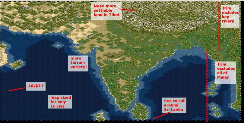
I love the Mughals scenario and play it quite often. I've even got an edited biq to let me do some things like play the Malacca Pirates. Can't win but it's fun being a spoiler. So I'm fairly familiar with its map. The map is very well suited to that scenario. OTOH there are some potential pitfalls in adopting it for use with this scenario:

  • Scale - imho it's slightly too small. The Mauryan era saw establishment of towns as well as conquest, so there ought to be some room for expansion. There are 16 civs in the Mughals scenario. Cropping the Eastern edge effectively eliminates the room occupied by a few of those. Placing 20+ civs will make it too cramped.
  • Cropping - a straight cut of the Eastern edge to remove all of the Malay penninsula was suggested at one point. This would potentially removes the section of the Brahmaputra River from its exit of the Himalayas down to where it bends back around to become part of the Ganges Delta. This eliminates the Assam/Naga area and would effectively eliminate any challenge of Maurya from the East. China and the Spice Islands would also be out of the picture.
  • Extensions - Something would need to be added to represent Egypt. It could be done with one of the "symbolic" islands. If accurate geography is wanted it would mean adding to the West as much as is removed on the East - for the sake of one civ. The Southern edge of the map should be extended at least a couple of rows to allow more realistic naval action around Sri Lanka. Bactria is off the map to the North. To include it would require extending the map. Doing so raises the question of how to handle the rest of the northern section (Tibetan Plateau & ranges on the East) in terms of terrain & occupation - playability issues.
  • Terrain features - This is a lot more subjective than the previous points. As it stands the terrain serves the Mughals scenario very well. Need to look at it with fresh eyes to see how well it meets the needs of this scenario. Terrain variety has been minimized. Not a lot of interspersing plains & grassland. Not a lot of forests (not jungles) as would have been extant in the Mauryan era. Both the Ghat ranges are reduced to hills. They got their name because "ghat" can mean a difficult mountain pass. The Himalayas need several small valleys to represent places like Nepal & Bhutan rather than the one large area as the map stands. all these things affect gameplay in significant ways.

Annotated Screenshot of Mughal Scenario map
Spoiler :


Summing up (imho) - adapting the Mughals map requires significant reworking. All four edges of the map need to be shifted. Significant reworking of the terrain will also be involved. Both of those issues can be dealt with in the scenario editor or with Map Tweaker. The map ought to be scaled in order to provide room for the larger number of civs. This cannot be done with any of the available tools.

Suggestion - Use the Mughals map as a testing ground to construct the biq. At the same time construct a purpose built map. When it is ready it is relatively straightforward to import the rules in the editor and let it replace the earlier map as the biq.


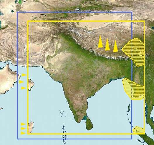
Here's an image that might be useful to download & annotate to post with further discussions.
 
Trade Civs: Two of them (China and Arabia) can be actual locations. The Andamans can serve for the Spice Islands. With regards to Egypt, I was thinking of just having a stand-in entrepot on the west edge of the map.

My thoughts on the map: It is very unpleasant for geography to be so unaccommodating. Suggestions:

1. East: Include all of Bangladesh. That would include the Andamans as well. Would that mean pirates? Just kidding.
2. South: Alllow much greater maneuvering room south of Ceylon.
3. West: As on the Mughal map.
4. North: We should extend the Mughal map north, but how far? See my suggestion on attached map. Extend the map too far north and you have a whole new crop of civs and a different slant to the game.

Wonders: Doesn't hurt to brainstorm while we put off a final decision.

General comments: I am swayed by your arguments. The Mughal map will not work; we will have to wait for a purpose built map. Per your suggestion, we can use the Mughal for testing.

Nagas: Do we have enough to make them a civ? Where would they go? To the North Eastern parts of Bangladesh?

Elephants: Since this is about India, the land of Ganesha, it makes sense and adds to the fun to have more than one kind of elephant resource and more than one kind of elephant unit. All in all, we are probably aways off from units.

Leaderheads: We have 19 civs requiring LHs. The trade civs can do with some flashy pictures. Only a few have been done which I think satisfy our needs. We need to either sharpen up our persuasion skills or I need to learn Poser. We can leave LHs to last. I wouldn't want to ask someone to help out in this area and then have us abandon the game.
 

Attachments

  • ir1.jpg
    ir1.jpg
    77.7 KB · Views: 145
Map
Wouldn't have to extend far at all to the north. Maybe just 4 tiles high (eight rows given the way tile rows interlock). Just enough to give Bactria some breathing room. We're thinking along the same lines. This is my first pass at it:


The shaded area on the upper right is the Brahmaputra area that's important for Bengal, etc. The middle area is represents the excess area we don't want - the actual area to be removed is larger. The lower right area is taking away the tip of Sumatra while leaving the "spice islands". Pasted stand-ins for Arabia & Egypt on the left. You're right about room for Bactria adding way too much of Tibet (the triangles pointing to the top).

One solution would be to manipulate/distort sections of the map to make desired parts (central to game play) larger and functionally peripheral areas smaller. This was the technique used in developing the map for Born of Fire. Upside is that the result is a map fine-tuned for game play. Down side is that there's a lot of time/effort before actually making the map. A lot of cutting, resizing and pasting bits and pieces with discussion all along the way.

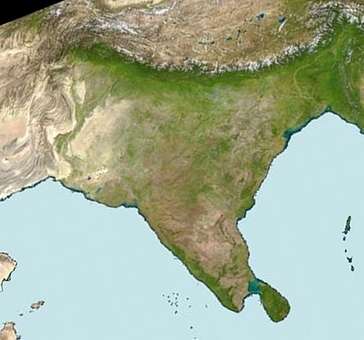
Once over the hurdle of accepting that the map is for a game - not RL navigation - there's a more elegant solution that's a lot faster to implement. Decide on the key geography to include, rotate to eliminate the undesired areas & crop. Voila:


This is a really quick'n'dirty version. Pasted in a slightly resized island group and chunks for Arabia / Egypt. The whole thing can be refined a lot faster than going the CnP/distort route. Advantages: quicker to develop and no visible distortion of local geography. Once desired size of came map is known can quickly get to making an image to process through BMPtoBIC. Disadvantages: can take a little while to adjust to "North isn't at the top". Once engaged in playing the game the effect is minimal - No one has similar worries on a randomly generated map.

Nagas
They don't need to be a major player. Can have a similar role to the Pirate faction in Mughals. Harass the bigger civs. Limit access (temporarily) to certain resources & areas. Just used them as a better-known representative for the many tribal groups in that area. Looked at as a whole there is definitely enough info on the area's people to put together a civ. Analogous to picking one tribe to represent all of New Guinea. Put them in all the jungly/mountainous areas in the far Northeastern corner. Basically a buffer between Bengal & China.

Requests for LHs, etc.
Use stand-ins for now. If this project gets up to speed it overlaps with other people's wants & needs. Rob is big on getting a ratha unit. Ares wants an elephant worker. They're not the only ones in either case. It shouldn't be that difficult to get things made once people see they will really have a home. A simple case of back-scratching.
 
It all sounds good. A rotated map occurred to me but I tossed it off as not being feasible. I agree also that the Mughal map may be a little small. As you say, this is a map for a game - total accuracy at this scale is not possible or a requirement. I say let's go with your rotated version/ I guess I can live with the reductions in the north west.

Does Egypt have to be an island? I was thinking of it as being at the extreme western end of the road leading out of Persia towards India. But a one square island works also.

Interesting name India. It seems that it is made up. At partition the Pakistanis wanted to name Pakistan, India, because the Indus river civilizations were in Pakistan. There was some kind of agreement that neither country would use the name but then what is now India pulled a trick on Pakistan and grabbed it.
 
... I say let's go with your rotated version/ I guess I can live with the reductions in the north west.
Mark what you want included in the Northwest on another copy of the satellite image. The rotation is completely arbitrary - no need to exclude any territory that is wanted.

Does Egypt have to be an island? I was thinking of it as being at the extreme western end of the road leading out of Persia towards India. But a one square island works also.
IIRC the Egyptian trade was through ports like Aksum. The Tamil civs definitely traded by sea, not overland. But that's based in knowledge of the Roman era. What's portrayed in the image is a shifted Horn of Africa. Meant to reach the edge of the map (yellow boundaries).

Interesting name India. It seems that it is made up. At partition the Pakistanis wanted to name Pakistan, India, because the Indus river civilizations were in Pakistan. There was some kind of agreement that neither country would use the name but then what is now India pulled a trick on Pakistan and grabbed it.
Sindh, Hind, Hindustan, ...

Sembiyan Mahadevi is now available to download ;).
Thanks, Rob.
 
@ Rob - I thanked you for Sembiyan over at at the download thread but I will do it here also. Thank you and great job. Always nice to get an early Christmas present. :woohoo:

@ Blue - I've taken another look and I think the rotated map will work as proposed. :whipped:

@Big: Thanks for the suggestion; we will investigate.
 
Note re the Kushans: at the time of this scenario they were still in NW China. They didn't arrive in the vicinity of Bactria/Sogdiana until around 150 B.C.E.
Absolutely correct. I'm open to suggestions for a simple collective proper noun to describe the Pahlavas, Sakas, Yuezhi (Tocharians), as well as other Indo-Scythians and Indo-Parthians. Mleccha isn't suitable. It's as generic as barbaros. Mleccha would include Hellenes, Egyptians, and Chinese. In game terms Mleccha would be a culture group rather than a civ.

Oops, I forgot a Civ:

Gangaridai - ? - ?
This civ occupied what is now Bangladesh.
Gangaridai is a Greek name. Since this is an Indian scenario rather than one focused on Alexander wouldn't it be more appropriate to use local names? Porus is another example of a Hellenization of an Indian name. Three guesses who Sandrokottos is.

ATM there are four Hellene civs (only one less than the Tamils, one more than the Nepalese group), no Tibetan, ... Within a chronological focus narrow enough to exclude the Kushans the Macedonians really shouldn't be in the mix either. Also, the list as it stands has too many culture groups. The game only allows 5. Perhaps Deccan, Gangetic, Tamil, Himalayan and Mleccha (Greeks & Traders) would provide a more Indian way to look at the civ groups. Deccan could encompass the more Western civs now in the Northern group & perhaps non-Hellene civs of the Hindu Kush. Might consider shifting one or two of the geographically central civs to the Tamils as well. Tibetan group could be expanded to include something from the peoples of Kashmir, Ladakh, U-Tsang, etc. Maybe the Zhangzhung? Making these changes would balance the numbers between the various culture groups and more realistically represent the historical situation of the period.
 
Top Bottom