Image to map converter?

Ultramarine

Chieftain
Joined
Apr 10, 2007
Messages
51
Location
Kronus
:confused:Is there a tool or utility program out there that can convert this image into a civ map biq?


I looked through the utility programs section real quick and didn't see anything.
 
BMP to BIC is available, though I've never used it either. From the bic it can be imported in the editor to a biq.

http://forums.civfanatics.com/showthread.php?t=96884
That's the one, although the image has to be square & reduced to a size where one pixel = 1 tile.* Also it has to use a special 16 color palette which is described in the thread. After the conversion a fair bit of cleanup will need to be done in the editor.

* It is possible to make a map larger than BMPtoBIC can handle by cutting it into pieces & then using Map Tweaker to reassemble it.
 
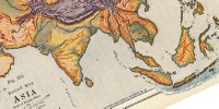
Thanks guy's I'll give the bmp2bic program a try. It' still looks like it's going to be a "be-hatch" to do with my limited skills but, I don't think I can pull it off freehand and have it come out good.

@Gary- That tool with civ3mod maker looks to be just a pcx converter and the map converter that comes with civ3 multi tool is just to convert civ2 maps to civ3.

If anyone who has experience with using the bmp2bic program could give me some tips and advice for converting the above image it would be greatly appreciated.
 
If anyone who has experience with using the bmp2bic program could give me some tips and advice for converting the above image it would be greatly appreciated.
"Tips & advice" unfortunately turns into one of my long, long posts. But since it was a request:


BMP2BIC Method
I mentioned the basics above:
That's the one, although the image has to be square & reduced to a size where one pixel = 1 tile.* Also it has to use a special 16 color palette which is described in the thread. After the conversion a fair bit of cleanup will need to be done in the editor.

* It is possible to make a map larger than BMPtoBIC can handle by cutting it into pieces & then using Map Tweaker to reassemble it.
The steps I have used are used are -
  1. Convert the image to a 16 color palette using the graphics program of your choice
  2. Change the resulting color areas to the palette used by BMP2BIC.
    • This is the most time consuming step because often you have to paint pixel by pixel.
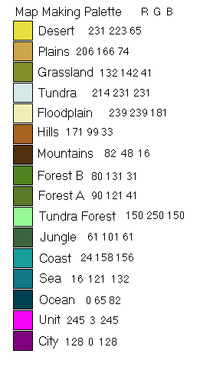
    • To help myself with this step I made a little chart with the colors, terrain types, & the RGB numbers so that I can have it on screen while I do the work.*
  3. Reduce The map to a size BMP2BIC can handle - remember that BMP2BIC can only handle square ** .bmp, up to 256x256.
  4. Use BMP2BIC to convert the .bmp into a map.
    • The comment in the quote about doing larger or oddly shaped maps by slicing means to make separate square .bmp, convert them, then use Map Tweaker to join them.
  5. Open the editor to do terrain clean-up & add resources, start locations, etc.
* my BMP2BIC palette guide:


** Potential Pitfalls

I did a post discussing the map design problems with understanding that tiles are single pixels even in game. One fundamental problem is that in .bmp the pixels are a square grid, while the Civ map uses a diamond shaped grid. Here's a post ,with discussion following on in further posts, illustrating the problems with converting a square, one pixel over another, image into the isometric tile-shaped maps of Civ. To get a decently shaped map the image had to be stretched taller, empty ocean colored bands added to make it square, then the empty ocean had to be cropped off, either in Map Tweaker or the editor, to make a usable map.


Grid Overlay Method
It' still looks like it's going to be a "be-hatch" to do with my limited skills but, I don't think I can pull it off freehand and have it come out good.
This Map Making thread has a good discussion of how to do a decent freehand map & works very well if the map is already a digital image, as you have. Be sure to read all two pages because several variations are discussed and the best ones (IMHO) come last. The biggest advantage is that you can do all kinds of shapes & sizes of maps. & The method doesn't depend on your level of artistic skill - just starting with a decent map & patient application of effort.


Comparing The Two Methods

My personal experience is only with 2 posted maps produced so far:

The Rise of Asia map was done "by hand" using the "grid overlay" method. It has gotten a lot of favorable comments & has even had a recent revival in terms of download frequency. It only required 2 programs: a graphics editor to do the grid overlay & the civ editor. Straightforward if time consuming - the civ editor step is just to stamp out the map in the editor, following the gridded image as a guide. I draw the coast lines & then quickly fill in using all plains. Then I go back & place the actual terrain tile by tile.

The MesoAmerica map was done with the BMPtoBIC method. I thought it would be much quicker & it was. But I had to use four programs - a graphics editor to make the .bmp, BMPtoBIC to convert it to a map, Map Tweaker to slice out the part I wanted ( I found cropping easier there after trying unsuccessfully to use the editor), & finally the editor. At that point I had a map that really showed it was done "quick & dirty". Most of the problems were caused by the conversion process although it's on me that I posted the map without correcting them. Going back to correct so many errors was almost impossible for me to sort out & track. So for the newer version, which was laid aside unfinished while waiting for RedAlert's return, I chose to start from scratch with a good image & use the "grid overlay" method (the key discussion that lets you see the "grid overlay" design process in action carries over to the next page).
 
:worship: Thank you so much for that in depth post Blue Monkey!
I could tell that you were trying to nudge me in the direction of the grid overlay method a bit, but "patience is a virtue", and unfortunately not one of mine....lol

I don't have photoshop, so I couldn't use the template for that. I also didn't have a program to open azmorg's template. I tried to lay a grid over the map in PSP, but could only get a square one.

I started painting the map the bmp2bic way, and I'm finding it fairly easy so-far and seeing progress helps me stay motivated and focused. (-not an easy thing to do-) I don't need a very large map. There won't be that many civ's on it and the mechanics of the scenario ( pace of play, rules, victory conditions, and # of cities, etc) will benefit from a mid size map. I'm trying 180x180 to start.

I will post progress reports here for anyone following this who may be interested in trying out the program.

After I converted the palette I figured it would be easiest to first paint in all the land one color first to get the basic outlines edited to my liking. I chose jungle since that will be the dominant terrain type anyway. Before I finished the outline I realized The ocean, sea, and coast would be a snap with the fill tool, so I did that.

Here's where I'm at now.

 
It looks like you've got a good start. I'll follow your progress, and be ready to comment where I can. Feel free to ask more questions any where along the way.

While searching for something else I cama across a post i made in another thread about a way I've used Map Tweaker + BMP2BIC to make an existing map larger.

As far as grid overlay - I think you may have missed the posted link in the other thread to a site that lets you make & dl grids in various shapes sizes & even colors. Once I've downloaded a grid I use a program like GIMP that let's me select by color to create a transparency, then I've got a saved grid ready to lay over any map. I've got several map projects on the back burner. The one I'm currently working on is for a mod about the ancient period in India.
EDIT: Here's a thumbnail of the base map:


And here's a version I also work with based on satellite imagery:


I'm not really trying you convert you to the grid method. I just figure it's worth discussing here since I'm sure there are lurkers reading it. One advantage of having a grid overlay saved is that I can create a grid with the number of tiles I want, scale the map (like either of those images above) to match, then save it. That way I can quickly preview the map as it would appear in-game at different scales (Huge, Large, etc.) and decide which scale will work best (room for the number of civs I want, etc.) before i set to work in the editor. That might be handy even if you end up going to BMP2BIC to make the actual map, since it would help you decide what dimensions to scale it to.

Edit 2
: Another thing I do with the grid is overlay it with a rectangular grid that helps me track where I am (counting tiles as I change terrain in the editor), like this:

 
I also overlay the grid to keep track of where I am makes things easier. Ultramarine you are going to lose the majority of that detail when you convert the image.
 
Ultramarine you are going to lose the majority of that detail when you convert the image.
That's why I mentioned the "1 tile = 1 pixel" concept. Getting that idea straight helps with map design. Larger map = more detail = coastlines, etc., look more "realistic". Smaller map = less detail = chunkier look with coastlines & mountain ranges looking zig-zaggy. When I referred to "clean up in the editor" mostly it's making those kinds of aesthetic corrections. But there's no way to avoid loss of detail at the map scales C3C can handle. One tile may represent 100+ km of territory - think about the amount of terrain change that happens in RL in an equivalent span.
 
I seem to have a slight problem or maybe I'm just not doing something right.

I painted all the land tiles jungle:


I opened up the bmp in the bmp2bic program and set the preview to civ3(I'm not too happy with the way it tilted and stretched the image,but that's not the problem)Then I clicked generate map:


I opened up the civ3 editor, clicked open file(it took me a while to figure out where the program generated the bic file and finaly found that it creates it where the original bmp file was), but when the map comes up it's blank. no land tiles. The # of tiles are correct by the coordinates. Any ideas as to what is wrong?
 
I'd double check that the color numbers are correct, BMP2BIC can only process exactly those RGB settings. Also, try changing the color in the bmp to the plains & rerun it. Revisions to BMP2BIC were left incomplete - maybe there's a problem with jungle. I don't think I bothered with the "overlayed" terrain like forest & jungle at that stage so I don't have a definitive answer.
 
I myself have never done it as jungle I think that may be the problem I would use either plains or grassland or a combination of each.
 
I checked the RGB of the map bmp and they match the palette RGB's. I changed the terrain to plains and hills and it still doesn't work......grrrrrrrr:mad: dammit where's my...:badcomp:

If you guy's would like to give it a whirl to see if it works for you here's the bmp I'm using:
 
Click download, open photoshop check colors open bmp to bic save open conquests edit save. Here you go
 

Attachments

  • Lustaria.zip
    19.7 KB · Views: 114
Thanks BadKharma, so your saying you didn't change anything? Then that must mean the version of bmp2bic I have is messed up then, because I re-ran it several times and always the same result......
 
I re-downloaded the program, which didn't help. I checked the thread and theres no mention of the bmp having to be in a specific location. BK, do you know if the file has to be loaded into the program from a specific location?
 
I have never had any problems like that. I loaded the bmp from the desktop and my bmp to bic folder is on a separate hardrive from windows.
 
Top Bottom