As we all know, Civilization IV came with an official Earth Ice Age map. Inspired by it, I started reading about this fascinating period in our planet's history. I had heard about the ice age, of course, but I had never studied it in any detail. I soon became thoroughly absorbed by the subject. I also realised that the original Civilization IV map, though fairly fun to play, contained a number of errors. I decided that I would try to create a better one, and a bigger one as well.
My map will portray the Earth as it looked like some 20.000 years before the present time, at the Last Glacial Maximum (LGM), the peak of the last ice age. The great thing about an Earth map like that is that it is both familiar and alien. You recognise all the continents and basic shapes, but there are giant ice sheets that cover large parts of Europe and North America. There are some additional land masses resulting from the lower sea levels, like Sundaland. There are different lakes and rivers. Most importantly perhaps, the vegetation looks totally different from what we have today. How would human civilization have developed if it had started developing during that time? It is a tantalising question.
A lot of our knowledge of the Last Glacial Maximum is still tentative. I will try to use the best scholarship that is available on the web, but on many things, as I know by now, there simply is no consensus in the scientific community. What was the exact extent of the ice sheets? Were there ice-dammed lakes in Siberia during the LGM or not? Where did trees grow, and how widespread were they? My design philosophy will be that, whenever there is an open issue like that, I will go with the option that is more interesting in terms of gameplay.
I originally planned to use Genghis Kai's Giant Earth Map (GEM) as a base. But as that was a typical Civilization map which unrealistically enlarged Europe and Japan, areas which are mostly tundra during the ice age, I have now decided th build my own map from scratch. The size will be comparable to the official Civilization IV Earth map, not gigantic. I might still do a gigantic map later on depending on how this first project works out and what feedback I get.
Since it will take me some time to make the map, I thought I would accompany the development with this thread here, which will allow me to gather feedback and suggestions while I go along. I hope that you will find the project interesting.
Development Chapters:
I. Coastlines
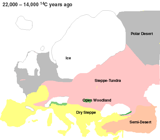
2. Climate and Vegetation
My map will portray the Earth as it looked like some 20.000 years before the present time, at the Last Glacial Maximum (LGM), the peak of the last ice age. The great thing about an Earth map like that is that it is both familiar and alien. You recognise all the continents and basic shapes, but there are giant ice sheets that cover large parts of Europe and North America. There are some additional land masses resulting from the lower sea levels, like Sundaland. There are different lakes and rivers. Most importantly perhaps, the vegetation looks totally different from what we have today. How would human civilization have developed if it had started developing during that time? It is a tantalising question.
A lot of our knowledge of the Last Glacial Maximum is still tentative. I will try to use the best scholarship that is available on the web, but on many things, as I know by now, there simply is no consensus in the scientific community. What was the exact extent of the ice sheets? Were there ice-dammed lakes in Siberia during the LGM or not? Where did trees grow, and how widespread were they? My design philosophy will be that, whenever there is an open issue like that, I will go with the option that is more interesting in terms of gameplay.
I originally planned to use Genghis Kai's Giant Earth Map (GEM) as a base. But as that was a typical Civilization map which unrealistically enlarged Europe and Japan, areas which are mostly tundra during the ice age, I have now decided th build my own map from scratch. The size will be comparable to the official Civilization IV Earth map, not gigantic. I might still do a gigantic map later on depending on how this first project works out and what feedback I get.
Since it will take me some time to make the map, I thought I would accompany the development with this thread here, which will allow me to gather feedback and suggestions while I go along. I hope that you will find the project interesting.
Development Chapters:
I. Coastlines
2. Climate and Vegetation