Here's some pointers on modding maps suitable for Planetfall. Sorry I didn't post this before Silverr, but I didn't expect you to make the Map of Planet so fast.
Plot types/"Elevation":
In SMAC terrain can only increase at most 1000m per plot. Planetfall does not have this restriction with Lowlands/Highlands/Ridges. Furthermore, elevation serves a different gameplay purpose in Planetfall. Its main effect is on the spread of fungus. Fungus can never grow on Ridges, and only on Highlands at high Flowering Counter levels. In addition, you cannot move directly from a lowland plot to a ridge plot, or vice versa. This turns long ridges of Ridge into a defensive barrier. These two effects together can create easily defendable fungus-free zones, which makes running a Terraformed strategy easier. Without large stretches of highlands+ridges, such a strategy would be very impractical. Therefore it's not advisable to try to copy the elevation encountered in the SMAC Map of Planet, where all the coast is lowland, and the more inland, the higher the elevation generally speaking. There should be several plateaus of highland bordered by ridges. And a considerable percentage of the coastline should be Highlands.
Terrain types:
The land terrain is pretty straightforward. Planetfall's Flat/Rocky Arid/Moist/Rainy resembles SMAC's Flat/Rolling/Rocky Arid/Moist/Rainy close enough.
One difference though: Planetfall adds Polar terrain. This is not included in the map you made. I think some should be added to give room for bonus resources which only occur on Polar terrain to spawn.
Sea terrain: SMAC also had elevation err I mean depth for water terrain. Planetfall does not have this, but it does have Coast, Shelf and Ocean terrain types. (Trenches are a feature now.)
Silverr, I noticed your map had lots of Coast terrain in the middle of the ocean. Is this an intentional move, or were you not aware of this because Coast and Shelf use the same graphic? There is a big difference between these two terrains as Shelf provides two nutrients and Coast one nutrient and two energy. Premade maps can take liberties which are impossible in mapscripts, such as placing Coast terrain in the middle of the ocean. And this Coast terrain could fit to represent certain features of the Map of Planet, such as the Geothermal Shallows. But I don't think it should be used on so many places on plots not bordering land.
The opposite could be done too by the way, in limited locations. Shelf instead of the usual Coast could be placed next to land. The obvious place to do this is the Freshwater Sea of course.
Feature types:
The big thing to mention here is that no Forest at all should be placed on the map! That's introduced by humans to Chiron. The Jungle feature is native to Chiron, and should be placed en masse at the Monsoon Jungle location. It's good to also place occasional features on other spots near the equatorial region, as you did. That way certain resources like Rare Tropical DNA won't always only occur inside the Monsoon Jungle.
Jungle and Xenofungus should only be placed on Lowlands.
I'd prefer a generally thicker Ice cap, with lots of inlets. I have some ideas (focused around the Enclosed Biosphere theme) to make this feature more interesting.
Trenches: the SMAC Map of Planet had trenches in the middle of the ocean, evenly placed between continents. Again a limitation of the SMAC elevation system. In reality it's the other way around. Ocean ridges (can be represented by Shelf) often occur in the middle between continental plates. And Trenches often occur right next to a coastal mountain ridge or an island chain. The mapscript represents this by only allowing a Trench to occur if at least one adjacent plot is a highland/ridge and at least on adjacent plot is Ocean terrain. Sea fungus cannot grow on Trenches. As a consequence, trenches serve the same function as Ridges on land: a barrier against fungus, giving easier sea access to those following a Terraformer strategy. While once again liberties could be taken with Trench placement on a premade maps, placing them on plots the mapscript would never do, I feel their main gameplay function should not be forgotten.
Earth Ocean trench and ridge map as illustration:
Resources, unity pods and landmarks
Good news! I had a look and it is in fact possible to randomize resource placement by changing a single line in the WorldBuilder file. By copying a few python code lines from Fall from Heaven, I could also let unity pod and spawning spot placement be randomized. So need to worry about those.
I would prefer to have landmarks at their SMAC location though. This is not the case in your map.
***
I had a look at the Utility Programs forum, and found a program to turn a Bitmap picture into a map for Civ4.

Download it
here. For it to work, I had to manually type 'import whatever' in the python console. Just double-clicking the scenario file didn't work.
I tried it the process on both the minimap of the Standard and Huge Maps of Planet. The standard-sized minimap gives too much land IMO, but the huge-sized minimap too little. I attached some screenshots for comparison.

") that not all your work is lost.
that not all your work is lost.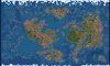


") I played a few turns with it and noticed two things:
I played a few turns with it and noticed two things: