Prelude
Hello gentlemen of the Colonization forum. I am pleased to announce that I will soon be releasing my third map for public use. North America. North America will be the third map which I have created for the Col2 fan base, and I have to say, my most favorite. North America contains 4500 square tiles. The landmass is similar to Colonial America, excluding the Caribbean and South or Central America. Because of this exclusion, there is a lot more land tiles in North America than there are in Colonial America. Hopefully making for a better game! It is strictly North America, and not all of it. Although I named the map North America, it truly covers only the eastern part of the continent. Why did I make this map? I really like Colonial America, but I had some problems with how it plays. Players starting near New England in Colonial America, scout a lot faster, and therefore receive a much better head start than players on Cuba or the islands. In North America, everyone gets a relatively even head start. The land is rich. I'm in the process of testing the map, and making necessary improvements to game play before I publish the original release. Go ahead and give any feed back below, and I will update this thread when version 1.0 is ready for download. I hope this map is well loved enough to earn the title of North America.
Version 1.0 Released
Version 1.5 Released
Below are some screen shots of the map.


The first is a picture of the Nova Scotia region.
The second reveals the state of Michigan, the Great Lakes region, and the northeastern seaboard.
The third is an overview of the cotton states and the Appalachian mountains.
The fourth is a picture of the Gulf Coast, from southeast Texas to Florida.
----------------------------------------------------------------------
Making of North America v1.0
Just for fun, I thought I would quickly run through a few of the things that I did to make this map. Perhaps it may inspire people to make more maps for this amazing game.
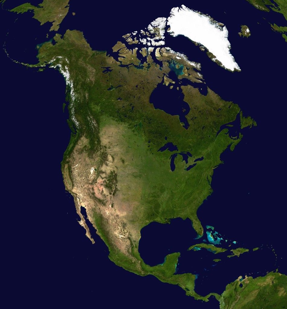
Step One is preparing the right map. I find my maps on-line, and rotate them to the desired angle, if necessary, and then trim to the right size.
In this particular case, I turned this map
into this

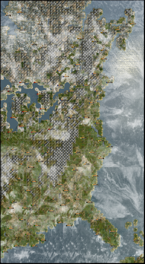
Step Two, open the map in GimpShop, and create a visual grid with squares 10 pixels by 10 pixels. In the case of North America, the map is 500 pixels by 900 pixels, as planned. The grid then splits the map into 4500 squares, 50 squares wide by 90 squares tall. These tiles correlate perfectly with the tiles in the world builder.
Here is an example of this process using the West Indies map. The map is 880 pixels by 580 pixels, or 88 tiles wide by 58 tiles tall once the grid has been set. I use two colors, green and blue, to distinguish land and sea. I then trace the edges of the land in the original map, with an easy to see color guide.

Step Three, is opening up a worldinfo file and editing the map size for a huge map. I set the size to 50 x 90. Then I proceed to open up the map in a normal game, and then open the world builder. In the world builder, I delete the generate random world. Using my gimp edited map as a guide with the grids, I trace the new land masses into the ocean.
Step Four, after tracing the basic landmasses, use a physical map of the region to place mountains, hills, and rivers.

Step Five, to make the game playable, I set up the equivalent of temporary cities all over the map. Using the guides seen below, I have carefully chosen terrain type and forestation. My general formula for an optimal colony is generally 1-2 hills per town, 2 forests, 3 farm or coastal tiles, and the rest specializing in trade (tobacco, cotton, etc.). Playing North America, you will see this formula is pretty prevalent, and there is an optimal place to put most every city, unless natives get in the way, or randomized resources upset the balance.


I just recently started to do step five. Steps five and four can be done at the same time. I kept going back and forth while making North America.
Hello gentlemen of the Colonization forum. I am pleased to announce that I will soon be releasing my third map for public use. North America. North America will be the third map which I have created for the Col2 fan base, and I have to say, my most favorite. North America contains 4500 square tiles. The landmass is similar to Colonial America, excluding the Caribbean and South or Central America. Because of this exclusion, there is a lot more land tiles in North America than there are in Colonial America. Hopefully making for a better game!
It is strictly North America, and not all of it. Although I named the map North America, it truly covers only the eastern part of the continent. Why did I make this map? I really like Colonial America, but I had some problems with how it plays. Players starting near New England in Colonial America, scout a lot faster, and therefore receive a much better head start than players on Cuba or the islands. In North America, everyone gets a relatively even head start. The land is rich. I'm in the process of testing the map, and making necessary improvements to game play before I publish the original release. Go ahead and give any feed back below, and I will update this thread when version 1.0 is ready for download. I hope this map is well loved enough to earn the title of North America.Version 1.0 Released
Version 1.5 Released
Below are some screen shots of the map.
Spoiler :
The first is a picture of the Nova Scotia region.
The second reveals the state of Michigan, the Great Lakes region, and the northeastern seaboard.
The third is an overview of the cotton states and the Appalachian mountains.
The fourth is a picture of the Gulf Coast, from southeast Texas to Florida.
----------------------------------------------------------------------
Making of North America v1.0
Just for fun, I thought I would quickly run through a few of the things that I did to make this map. Perhaps it may inspire people to make more maps for this amazing game.
Step One is preparing the right map. I find my maps on-line, and rotate them to the desired angle, if necessary, and then trim to the right size.
In this particular case, I turned this map
Spoiler :
into this
Spoiler :
Step Two, open the map in GimpShop, and create a visual grid with squares 10 pixels by 10 pixels. In the case of North America, the map is 500 pixels by 900 pixels, as planned. The grid then splits the map into 4500 squares, 50 squares wide by 90 squares tall. These tiles correlate perfectly with the tiles in the world builder.
Here is an example of this process using the West Indies map. The map is 880 pixels by 580 pixels, or 88 tiles wide by 58 tiles tall once the grid has been set. I use two colors, green and blue, to distinguish land and sea. I then trace the edges of the land in the original map, with an easy to see color guide.
Spoiler :
Step Three, is opening up a worldinfo file and editing the map size for a huge map. I set the size to 50 x 90. Then I proceed to open up the map in a normal game, and then open the world builder. In the world builder, I delete the generate random world. Using my gimp edited map as a guide with the grids, I trace the new land masses into the ocean.
Step Four, after tracing the basic landmasses, use a physical map of the region to place mountains, hills, and rivers.
Spoiler :
Step Five, to make the game playable, I set up the equivalent of temporary cities all over the map. Using the guides seen below, I have carefully chosen terrain type and forestation. My general formula for an optimal colony is generally 1-2 hills per town, 2 forests, 3 farm or coastal tiles, and the rest specializing in trade (tobacco, cotton, etc.). Playing North America, you will see this formula is pretty prevalent, and there is an optimal place to put most every city, unless natives get in the way, or randomized resources upset the balance.
Spoiler :
I just recently started to do step five. Steps five and four can be done at the same time. I kept going back and forth while making North America.
")
