Hi, this is my new map of all of southern Greece. For those who have dled my southGreece v.1 or v.1.1 note that those maps were just of the south, whereas this reaches up to 1/3 of Epiros, so is really almost half of Greece. To the west all islands are in apart from Corfu which is in the north, and to the east some islands arent in because they would involve presenting asia minor as well (for example Rhodos and Samos arent in).
in my view this map should provide for fun games, since the mountains and hills present natural borders, as they did in ancient times. Certainly post feedback because its nice to read it")
As for sea tiles: i made a nautical map of the aegean, as best as i could with using just 3 different sea tiles, this is why some coast exists away from some islands, it shows that the waters there arent very deep.
**Note** : This map HAS Crete in, which isnt correct in reality. There is a second file near the bottom of this page which has the map without Crete.
note: this isnt a new version of my southern greece map, because it is 15% bigger in size in total, and significantly more bigger if one simply takes out the eastern ocean part in that map using maptweak. so for slower computers i would suggest the use of that map.
Kyriakos
in my view this map should provide for fun games, since the mountains and hills present natural borders, as they did in ancient times. Certainly post feedback because its nice to read it
As for sea tiles: i made a nautical map of the aegean, as best as i could with using just 3 different sea tiles, this is why some coast exists away from some islands, it shows that the waters there arent very deep.
**Note** : This map HAS Crete in, which isnt correct in reality. There is a second file near the bottom of this page which has the map without Crete.
note: this isnt a new version of my southern greece map, because it is 15% bigger in size in total, and significantly more bigger if one simply takes out the eastern ocean part in that map using maptweak. so for slower computers i would suggest the use of that map.
Kyriakos
") what you are watching is argolis and achaea (part), then attica and boiteia, then euboia. and, ofcourse, the minimap
what you are watching is argolis and achaea (part), then attica and boiteia, then euboia. and, ofcourse, the minimap 
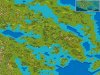
 ).
). I always use grassland instead of plains and so i didnt really care about where plains are, although some are placed.