South-West Pacific 150x120

Margim

Footy's back.
Joined
Oct 6, 2003
Messages
1,449
Location
Aussieland
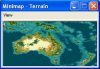
This is my first effort at mapmaking - screenshot to follow. Its for a mod I hope to pull together one day focusing on the oft-neglectic corner of the world that I live in. The map focuses on the South West Pacific and contains Australia, New Zealand, eastern Indonesia, Papua New Guinea, New Caledonia and Fiji.

I've attempted to produce as much detail as possible with gameplay in mind, thus making some of the middle sized islands (NZ, Tasmania) a little larger (2-3 squares) than normal. I've made much of Australia's desert into plains instead, for a little more settling space.

This is a clean map. I have not placed resources as some essential civ resources (ie horses) don't naturally occur - I wasn'[t sure what to put in and leave out. Let the random seed do its thing.

Enjoy
 

Attachments

Here's the screenshot. Should mention that the map is in biq format.
 

Attachments

  • MAP.JPG
    MAP.JPG
    11.2 KB · Views: 1,847
It seems to be corrupted or something, I can't get it to open. From the screenshot it looks quite skillful, especially for a first effort in mapmaking.
EDIT:
After reinstalling conquests it worked appropriatly and on a closer look I found it to be skillful indeed.
A few questions, however, will be made.
1. The Cook Strait. Why was this left out? It also seems a little odd to have the two starting locations so close, rather than one in the North Isle and one on the South giving more expansion space. As it is the civ that starts in Wellington will get the whole South Island plus quite a bit of the North.
2. The rivers in the North Island. These seem to be a bit odd, they are not full length and several of them don't reach the sea. Unless they are lakes, but one of them seems to be where the Whanganui is.
3. Perhaps there is a little too much grassland around about and not quite enough plains, but that is pushing it criticism-wise.

Regardless of these minor problems this is a very nice map, which also looks very accurate :goodjob:
Amazing for a first go :eek:
 
Nice map.

I've got some good links that'll show you where to put the resources that I used for mine. If you want them just let me know.
 
I admit New Zealand isn't my strongest point. However,
1) the cook strait was left out for a reason - mainly because I made the map with a specific future scenario in mind, splitting the Pakeha and Maori into two seperate civs. Most of the Maori history of conflict with Anglo settlers that I could find took place in the north Island. Wellingotn, too, is on the north island, yet two civs on the north island would get nowhere. I decided to compromise to make one larger island, with 'Wellington', as it is now, being the main thoroughfare between North and South (a ferry takes a little imagination). Feel free to change it as suits :).
2) As for rivers, the map I was working off had several outlets, and since my knowledge of local geography is limited, I wasn't sure what the main rivers were - so I made many of them rather vague. I think some of them I tried to manipulate to represent islands or little penninsulas. I find local knowledge reveals many flaws in map making :) I've been very frustrated at most world maps that have Hawaii three times the size of Tasmania, for example.
3) For NZ or Australia? Australia is more or less grassland on the east coast and in the south west, and desert everywhere else. I figured consideing the small size of much of the other landmasses, more grassland would compensate for the lack of available squares and city overcrowding.

Thanks heaps for your comments, however. If you've got a picture that could clearly show me the main rivers worth identifying in NZ, I'd love to see it.
 
For anyone whose interested, this thread contains the idea I had for this mod, with ideas for drawing together the various civs whose starting localtions I've placed on the map. Aboriginal tribal names roughly represent an amalgamation of language groups with cities and leaders drawn from a 'general' geographic proximity. Help on New Zealand and the Maori (the city lists especially) would be greatly appreciated.

http://forums.civfanatics.com/showthread.php?t=105595
 
Maps of the entire SW Pacific Region including several of New Zealand:

http://www.lib.utexas.edu/maps/australia.html

Dude, how can you make a CIV map without using maps for reference? the utexas site above is a goldmine of current and historical maps.

Margim said:
...Thanks heaps for your comments, however. If you've got a picture that could clearly show me the main rivers worth identifying in NZ, I'd love to see it.
 
rajwhitehall said:
Maps of the entire SW Pacific Region including several of New Zealand:

http://www.lib.utexas.edu/maps/australia.html

Dude, how can you make a CIV map without using maps for reference? the utexas site above is a goldmine of current and historical maps.

I never said I used no maps. I actually used several, one of the entire region and then smaller ones of specific areas. I merely had trouble with identifying which rivers to focus on with NZ's north island.

That said, thanks for the reference. Looks very useful. Cheers.
 
Back
Top Bottom