Jason The King
Deity
JNES: Classic
Introduction
Welcome to JNES: Classic. This is a board NES, which is implied by the classic part of the title. Therefore, all those die hard story fans who dont play any board games, you need not read any further. For all those interested in forging an empire stretching across Europe through arms of force or economic domination, you may continue to read. This game is moderately complicated, so please read slowly and carefully, and of course ask any questions you wish. The battle system is something that can be skipped for those who care little. It is also something that can be improved upon, and I am open to any suggestions of a system that can make use with the stats I have already laid out.
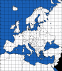
The Map
I guess we should start with the map. It is a map of Europe, a modern map since this does take place in modern times. The map was made by plexus a while back, from the first map thread, and took some time to find. Anyways, you may have noticed the lines crisscrossing across it. These form the squares that make it possible for movement in this game. In your orders, it is necessary to identify a square. To do this, you simply trace a straight line from your square to the top of the map, where you get the number of the column, and then trace from your square all the way to the left to find the letter of the row. Put these together (it doesnt matter which in which order they are arranged (example: C4 or 4C)) and you get the square identification. Fairly simple.
Why the squares?
The squares are used to track movement and movement only. Everything else, including borders and territory gained in a war, is still up to me, the mod. This means you could be attacking towards Paris in, but a French army stops you in K6. You then share the square with French forces, yet you still do not control Paris.
You may notice the map is covered in dots of two sizes. Each dot represents a city; the larger dot represents the capital. The significance of a city and a capital will be explained later, in the economy section. Some notes: Beirut lies in Q15, Luxembourg City is in K7. Each unit can move a certain amount of squares. But whats the deal with water? And a square that includes two coasts separated by water (example: J5)? Well, your forces will remain on their side of the water, and to cross they will need the appropriate crossing vehicle. Land forces in the same square but completely separated by a body of water cannot attack each other unless they are legally transported over the body of water.
I know there are some inaccuracies with city placement. But when referring to a city, pick the most obvious choice, some cities may have been moved due to the position of the square and whatnot.
I will not provide a named map. Check out the CIA factbook website for a detailed European map or consult your personal atlas (no NESer should be without one).
Introduction
Welcome to JNES: Classic. This is a board NES, which is implied by the classic part of the title. Therefore, all those die hard story fans who dont play any board games, you need not read any further. For all those interested in forging an empire stretching across Europe through arms of force or economic domination, you may continue to read. This game is moderately complicated, so please read slowly and carefully, and of course ask any questions you wish. The battle system is something that can be skipped for those who care little. It is also something that can be improved upon, and I am open to any suggestions of a system that can make use with the stats I have already laid out.
The Map
I guess we should start with the map. It is a map of Europe, a modern map since this does take place in modern times. The map was made by plexus a while back, from the first map thread, and took some time to find. Anyways, you may have noticed the lines crisscrossing across it. These form the squares that make it possible for movement in this game. In your orders, it is necessary to identify a square. To do this, you simply trace a straight line from your square to the top of the map, where you get the number of the column, and then trace from your square all the way to the left to find the letter of the row. Put these together (it doesnt matter which in which order they are arranged (example: C4 or 4C)) and you get the square identification. Fairly simple.
Why the squares?
The squares are used to track movement and movement only. Everything else, including borders and territory gained in a war, is still up to me, the mod. This means you could be attacking towards Paris in, but a French army stops you in K6. You then share the square with French forces, yet you still do not control Paris.
You may notice the map is covered in dots of two sizes. Each dot represents a city; the larger dot represents the capital. The significance of a city and a capital will be explained later, in the economy section. Some notes: Beirut lies in Q15, Luxembourg City is in K7. Each unit can move a certain amount of squares. But whats the deal with water? And a square that includes two coasts separated by water (example: J5)? Well, your forces will remain on their side of the water, and to cross they will need the appropriate crossing vehicle. Land forces in the same square but completely separated by a body of water cannot attack each other unless they are legally transported over the body of water.
I know there are some inaccuracies with city placement. But when referring to a city, pick the most obvious choice, some cities may have been moved due to the position of the square and whatnot.
I will not provide a named map. Check out the CIA factbook website for a detailed European map or consult your personal atlas (no NESer should be without one).
")