Hallo Lads and Gents
ive make a little tool to truncate os crop maps...
Features:
ToDO:
REQUIREMENTS:
this tool ist a php and javascript tool... u NEED:
INSTALATION:
ATTENTION:
a file u will upload is only a copy, the result is on screen
UPDATE: 6. Jan 2006 (version 05)
ADDED:
* graphical outfit updated
* all WBFile-Data will be read an write (improvements, units, citys...)
* map-legend
* terrain: all standart terrain-types and hills and mountains added
* map-data will be updated... grid width,grid height and num plots written
* starting position not supportet (u must look for right positions in player data)
Next Steps:
* map cleaner (u can delete some things u dont need...)
* set starting positions...
* ... needful things
ATTANTION: please delete the old version from ur htdoc folder... and extract there this View attachment MapTruncator.zip version...
Thx
GoodGames
greets
Kalderus
PS: sorry for my bad english... i work on it (since 20 years )
)
ive make a little tool to truncate os crop maps...
Features:
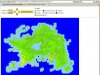
- u can crop a area from a bigger map: example => u have a 100x100 plot map and crop an area of NNxNN on each position
- this tool reads the plot-section of a CivWarlordsWBSave or Civ4WorldBuilderSave and get folowing values:
- x/y pos
- isXOfRiver
- RiverXXDirection
- FeatureType and FeatureVariety
- TerrainType
- PlotType
- all other values would be deletet in this version...
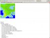
- + u get at the end a picture of ur crop erea, Shor Map Infos (grid width, grid height, num plots written) and the PlotList...
- what u must do is...
- copy PlotList from MapTruncator-Output (below the crop picture) and reaplace the PlotList in ur CivWarlordsWBSave or Civ4WorldBuilderSave File.
- copy relevant Map Infos in ur file
- dont forget ur civ-start-positions...
- think thats all
ToDO:
- needful things
REQUIREMENTS:
this tool ist a php and javascript tool... u NEED:
- an apache server or other server with php > 5.0 and the gd-libs (get XAMPP)
- FireFox 1.5.0.9 (i only test in it, but try others)
- activated javascript1.2 (?)
INSTALATION:
- install XAMPP (apache destr)
- unzip the View attachment MapTruncator.zip to the HTDOCS folder (Expample: c:\xampp\htdocs\MapTurncator\)
- start ur browser with URL: "http://localhost/Maptruncator/".. lets go
ATTENTION:
a file u will upload is only a copy, the result is on screen
UPDATE: 6. Jan 2006 (version 05)
ADDED:
* graphical outfit updated
* all WBFile-Data will be read an write (improvements, units, citys...)
* map-legend
* terrain: all standart terrain-types and hills and mountains added
* map-data will be updated... grid width,grid height and num plots written
* starting position not supportet (u must look for right positions in player data)
Next Steps:
* map cleaner (u can delete some things u dont need...)
* set starting positions...
* ... needful things
ATTANTION: please delete the old version from ur htdoc folder... and extract there this View attachment MapTruncator.zip version...
Thx
GoodGames
greets
Kalderus
PS: sorry for my bad english... i work on it (since 20 years
)
 (Well I have to say, I didn't test it until now, but it sounds great. This is, what I was looking for allready for long time.).
 , but a new is comming in the near future...
")