sarysa
Chieftain
Version 0.0.3-0420 is out! - 2008-04-20 hotfix
Civ4 Map Maker is an open source project. The first release was this morning at 1am pacific. The UI is still a bit primitive and geeky, but it's pretty feature packed in its early incarnation.
Project URL: http://www.sourceforge.net/projects/civ4mm (should always work)
CivFanatics URL: http://forums.civfanatics.com/./downloads.php?do=file&id=9239 (works only after mod approval)
Current version: 0.0.3-0420
Requires: JRE (Java) 5 or higher. Available at http://java.sun.com
The purpose of the project was to make map editing way easier than it already is, and to correct the many shortcomings of WorldBuilder. The code is based on previous map editors I made for 2d games I'm working on.
VERSION 0.0.3-0420 HOTFIX NOTES:
- Bugfixes: Importing/exporting Warlords and BTS saves, Auto-resource placement on impassable/unimprovable tiles, import not importing world size (would always be DUEL)
- Another hotfix to make coastlines less confusing to look at. Definite "DUH" moment for me, what was I thinking?!
- Added special functions to strip rivers/resources/routes/coasts, since I'd already made this anyway.
- Auto-resource will give the option to place 3 tribal villages per civ on the map at 100%. Future versions will support manual placement of tribal villages.
VERSION 0.0.3 NOTES:
- Fixed a bug where sheep and wheat were getting switched on export.
- Map editor now allows rivers and roads to be on the same square. (internally, rivers are
handled bitwise now)
- Implemented importing of maps. This can be pretty slow with larger maps, keep in mind.
- Moved selection tool to where the other tools are. The selection tool being where it was
was legacy code from my other map makers that were much simpler in that respect.
- Cut/copy/paste interface looks much nicer. If a region is copied (not cut) the copied region
will be highlighted red. The place where a region will be pasted is highlighted yellow.
- Created an undo/redo feature. Undo goes back as far as 100 changes to the map, currently.
- Created a new map feature, since it's annoying to have to close and open the map editor
to make a new map.
- Greatly improved auto-rivers.
- Allows more auto-resources to go onto more diverse tiles.
- Fixed severely faulty math with the random resource generation.
- Implemented custom map sizes. The old map size (which is actually a variable in the
Civ4WorldBuilderSave file) now determines for how many civs resources are generated.
- Shows x/y coords on tooltip text. And yes, Y's are backwards because that's how Civ4 works.
Included in 0.0.2:
- Cut/copy/paste/delete: You can copy-paste regions of any size, using the normal Windows keyboard shortcuts.
- Fill tool: Works like the bucket tool in paint programs.
- Resize/scale maps: You can resize[crop or expand canvas] the map, or scale[stretch] maps larger or smaller. (though the more you up/downscale them, the less they resemble the original maps, but going from, say, Huge -> Large turns out well)
- Auto-river: Automatically connects rivers, though currently only supports rivers that don't have more than two adjacent rivers. (in directions N-S-E-W) This is something I'll be fixing in 0.0.3.
- Auto-coast: Option to automatically create a coastline surrounding all land.
- Auto-climate: Option to automatically tweak the map's climate based on latitude/longitude.
- Tooltips: Optional tooltips tell you what's on the tile and estimates Production/Gold/Food.
- Auto-resource: Option upon export to randomly apply resources to the map. Allows you to scale the resources, where a 10% resource map would be one where people fight heavily for resources, while a 300% resource map is one where resources are plentiful.
The way it works right now, when you launch the program, you get an empty canvas with only ocean. You can use the tools to create the basic map layout, place whatever you want, then let the program do the rest if you'd like. (coastlines, climates, resources...) The map files usually used by the program are binaries that are only useful to the program, which makes it run much faster. (no parsing) The binaries store the map's version number, so your .map files today will still work with whatever version of the program is around two years from now.
To make maps that Civ4 can use, you'll have to export the map. That's when autoclimate, autocoast, and autoresource works. This means you won't corrupt your map by using these features. They're 100% safe! There's even a "Seed" feature that'll help make it so (but not guarantee) your maps will export with the same random resources/climate each time. (climate at certain latitudes is 50/50 randomized)
Here's some screenshots:
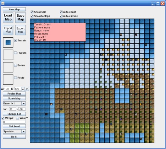
Version 0.0.3 hotfix screenshot. This is my current map, blown up to 130x120, auto-everything'd, exported, then re-imported back into Civ4 Map Maker. I'm just posting it to show that it can be done now, with all the auto-features your maps probably won't need to look so busy.") Note how the coastlines also look nicer thanks to the hotfix.
Note how the coastlines also look nicer thanks to the hotfix.
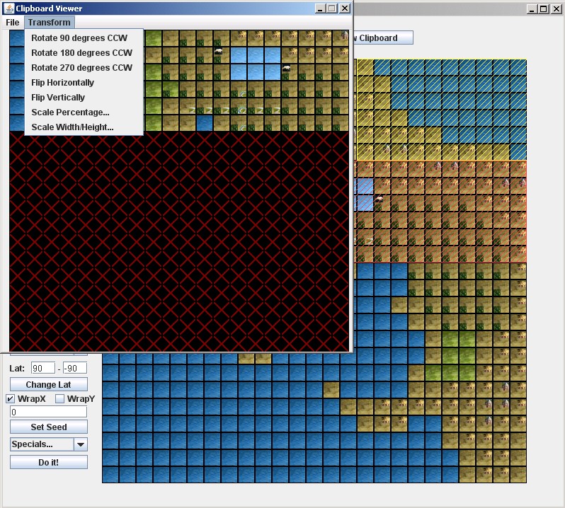
Version 0.0.3 screenshot. A little difficult to see because the image's downscaled, but you can now see the copy rectangle and/or paste rectangle. The copied tiles are highlighted red. The yellow rectangle shows where the clipboard contents will go. I couldn't get the mouse pointer in the screenshot, but it's pointing at the top-left tile in the paste rectangle.
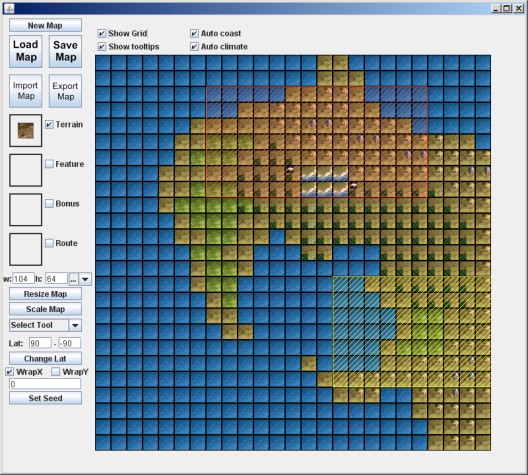
Version 0.0.3 "results" screenshot. Auto-rivers are nearly complete. All forms of rivers will connect now. This screenshot demonstrates how it tries to discern parallel rivers. There's a few kinks to work out, but your typical not-too-fancy rivers will always look correct.
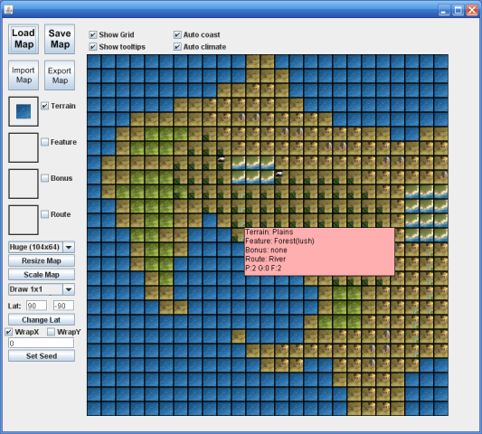
Version 0.0.2 screenshot. This is actually the map I'm working on.
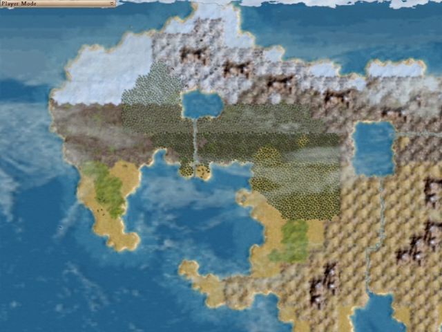
The previous screenshot, after being exported to a WorldBuilder save. Note that it's using all the auto-features.
Next version (0.1.0) will look at:
- Custom resources (as requested by Shqype)
- Bug fixes. There have to be a few by now...
- Mini-map that works similar to the WorldBuilder one
- More interesting transform tools. (rotate, manipulating the clipboard contents, etc.)
By the way, this is a 100% open source project, so if you're a skilled developer and want to contribute, you're welcome to do so. (provided your code is clean, readable, and stable)
Civ4 Map Maker is an open source project. The first release was this morning at 1am pacific. The UI is still a bit primitive and geeky, but it's pretty feature packed in its early incarnation.
Project URL: http://www.sourceforge.net/projects/civ4mm (should always work)
CivFanatics URL: http://forums.civfanatics.com/./downloads.php?do=file&id=9239 (works only after mod approval)
Current version: 0.0.3-0420
Requires: JRE (Java) 5 or higher. Available at http://java.sun.com
The purpose of the project was to make map editing way easier than it already is, and to correct the many shortcomings of WorldBuilder. The code is based on previous map editors I made for 2d games I'm working on.
VERSION 0.0.3-0420 HOTFIX NOTES:
- Bugfixes: Importing/exporting Warlords and BTS saves, Auto-resource placement on impassable/unimprovable tiles, import not importing world size (would always be DUEL)
- Another hotfix to make coastlines less confusing to look at. Definite "DUH" moment for me, what was I thinking?!
- Added special functions to strip rivers/resources/routes/coasts, since I'd already made this anyway.
- Auto-resource will give the option to place 3 tribal villages per civ on the map at 100%. Future versions will support manual placement of tribal villages.
VERSION 0.0.3 NOTES:
- Fixed a bug where sheep and wheat were getting switched on export.
- Map editor now allows rivers and roads to be on the same square. (internally, rivers are
handled bitwise now)
- Implemented importing of maps. This can be pretty slow with larger maps, keep in mind.
- Moved selection tool to where the other tools are. The selection tool being where it was
was legacy code from my other map makers that were much simpler in that respect.
- Cut/copy/paste interface looks much nicer. If a region is copied (not cut) the copied region
will be highlighted red. The place where a region will be pasted is highlighted yellow.
- Created an undo/redo feature. Undo goes back as far as 100 changes to the map, currently.
- Created a new map feature, since it's annoying to have to close and open the map editor
to make a new map.
- Greatly improved auto-rivers.
- Allows more auto-resources to go onto more diverse tiles.
- Fixed severely faulty math with the random resource generation.
- Implemented custom map sizes. The old map size (which is actually a variable in the
Civ4WorldBuilderSave file) now determines for how many civs resources are generated.
- Shows x/y coords on tooltip text. And yes, Y's are backwards because that's how Civ4 works.
Included in 0.0.2:
- Cut/copy/paste/delete: You can copy-paste regions of any size, using the normal Windows keyboard shortcuts.
- Fill tool: Works like the bucket tool in paint programs.
- Resize/scale maps: You can resize[crop or expand canvas] the map, or scale[stretch] maps larger or smaller. (though the more you up/downscale them, the less they resemble the original maps, but going from, say, Huge -> Large turns out well)
- Auto-river: Automatically connects rivers, though currently only supports rivers that don't have more than two adjacent rivers. (in directions N-S-E-W) This is something I'll be fixing in 0.0.3.
- Auto-coast: Option to automatically create a coastline surrounding all land.
- Auto-climate: Option to automatically tweak the map's climate based on latitude/longitude.
- Tooltips: Optional tooltips tell you what's on the tile and estimates Production/Gold/Food.
- Auto-resource: Option upon export to randomly apply resources to the map. Allows you to scale the resources, where a 10% resource map would be one where people fight heavily for resources, while a 300% resource map is one where resources are plentiful.
The way it works right now, when you launch the program, you get an empty canvas with only ocean. You can use the tools to create the basic map layout, place whatever you want, then let the program do the rest if you'd like. (coastlines, climates, resources...) The map files usually used by the program are binaries that are only useful to the program, which makes it run much faster. (no parsing) The binaries store the map's version number, so your .map files today will still work with whatever version of the program is around two years from now.
To make maps that Civ4 can use, you'll have to export the map. That's when autoclimate, autocoast, and autoresource works. This means you won't corrupt your map by using these features. They're 100% safe! There's even a "Seed" feature that'll help make it so (but not guarantee) your maps will export with the same random resources/climate each time. (climate at certain latitudes is 50/50 randomized)
Here's some screenshots:
Version 0.0.3 hotfix screenshot. This is my current map, blown up to 130x120, auto-everything'd, exported, then re-imported back into Civ4 Map Maker. I'm just posting it to show that it can be done now, with all the auto-features your maps probably won't need to look so busy.
Note how the coastlines also look nicer thanks to the hotfix.
Version 0.0.3 screenshot. A little difficult to see because the image's downscaled, but you can now see the copy rectangle and/or paste rectangle. The copied tiles are highlighted red. The yellow rectangle shows where the clipboard contents will go. I couldn't get the mouse pointer in the screenshot, but it's pointing at the top-left tile in the paste rectangle.
Version 0.0.3 "results" screenshot. Auto-rivers are nearly complete. All forms of rivers will connect now. This screenshot demonstrates how it tries to discern parallel rivers. There's a few kinks to work out, but your typical not-too-fancy rivers will always look correct.
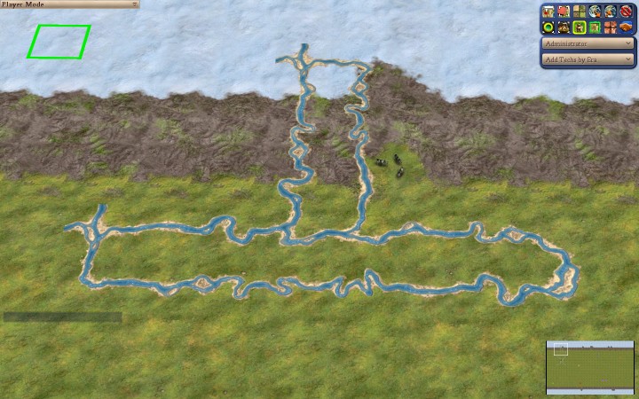
Version 0.0.2 screenshot. This is actually the map I'm working on.
The previous screenshot, after being exported to a WorldBuilder save. Note that it's using all the auto-features.
Next version (0.1.0) will look at:
- Custom resources (as requested by Shqype)
- Bug fixes. There have to be a few by now...
- Mini-map that works similar to the WorldBuilder one
- More interesting transform tools. (rotate, manipulating the clipboard contents, etc.)
By the way, this is a 100% open source project, so if you're a skilled developer and want to contribute, you're welcome to do so. (provided your code is clean, readable, and stable)

 The only difference being features and I think this one's the only open source project.

 (Sent you the file.)