Drewcifer
Agent of Karma
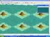
These tools are for people who want to create their own maps. These maps consist of ocean with a grid of mountains. All 5 standard map sizes are represented plus the largest size the editor will permit. The dimentions in the titles are the size of the grid drawn on the template. These templates came into existance as a result of my efforts to create maps of the Great Lakes and the South Pacific. The Great Lakes map used a different, diagonal grid that was less sucessful; the South Pacific was created with the current version. The basic process I used was as follows:
- Using tracing paper with a grid on it or graph paper that is so cheap that you can see through it, trace the map you want to use on to the graph paper (this may require placing a light under the map).
- Count the number of squares on both the X and Y axis of the map you have just drawn and compare it to the dimentions of the template you intend to use.
-Using this knowledge, decide on the scale the map you have just drawn relative to the template, one template square will correspond to a section of the map.
-When you have determined the scale of your map, you can put the template grid points on your traced map and draw lines between them, the squares you have just drawn on your map correspond to the squares on the template.
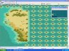
-At this point you can draw your map into the editor square by square, using an atlas, personal knowledge etc..
These templates are bic files so they are compatable with basic Civ 3 v1.29f.
- Using tracing paper with a grid on it or graph paper that is so cheap that you can see through it, trace the map you want to use on to the graph paper (this may require placing a light under the map).
- Count the number of squares on both the X and Y axis of the map you have just drawn and compare it to the dimentions of the template you intend to use.
-Using this knowledge, decide on the scale the map you have just drawn relative to the template, one template square will correspond to a section of the map.
-When you have determined the scale of your map, you can put the template grid points on your traced map and draw lines between them, the squares you have just drawn on your map correspond to the squares on the template.
-At this point you can draw your map into the editor square by square, using an atlas, personal knowledge etc..
These templates are bic files so they are compatable with basic Civ 3 v1.29f.