
Download Accurate Ice Age Earth Map
About this map:
This is a map of Earth during the last ice age, or more scientifically speaking, the Last Glacial Maximum (LGM) about 20,000 years ago. It is based on my Accurate Earth Map (132 x 64). Like that other map, it uses a cylindrical equal-area projection with standard parallels at 37.3 degrees north and south of the equator (sometimes known as the "Hobo-Dyer projection"). All continents and oceans are depicted with their correct areas relative to each other.
Obviously, it is impossible to make a perfectly accurate Earth map for Civilization. The Earth is a globe, so any representation of its surface on a plane is a compromise of one form or another, accurately representing some of the properties of the Earth's surface (in this case, area) at the expense of distorting others (in this case, shape and distance). Rather than a boast of perfect accuracy, calling my map "accurate" is simply a declaration of intention and design philosophy. Unlike many other Earth maps for Civilization IV (including the official one), mine do not feature an artificially enlarged Europe and Japan or an artificially reduced Pacific ocean. Instead, I went for as much geographical accuracy as possible, within the limitations of the game.
For this map, I tried to represent the Ice Age Earth as accurately as possible, given the state of our current knowledge. There is an official Ice Age Earth map for Civilization IV, but it contains some major errors. For instance, it shows land bridges across the Straits of Gibraltar and between Southeast Asia and Oceania that did not exist during the LGM (although sea levels were lower and the continents were closer together, there was still ocean between them). I used an assortment of academic sources for my Ice Age Earth map, the most important being A GIS-based Vegetation Map of the World at the Last Glacial Maximum (25,000-15,000 BP) by N. Ray and J.M. Adams (2001) for overall terrain and biome placement.
Tools used to create the map: NASA's Global Map Projector to convert various equirectangular source maps I had to the desired equal-area projection, Adobe Photoshop Elements to arrange my maps in layers and put a grid over them, and MapView 2.0 for the actual work.
A lot of work went into this map. I hope that you like the result. Have fun, and don't hesitate to send feedback and comments!
About the Ice Age:
So here is a look at the Earth during the Last Glacial Maximum: huge ice sheets cover northern Europe, northwestern Siberia, Canada and the northern US, and the Andes in South America. Because of all the water trapped in the ice, global sea levels are some 120m lower than during the current era. The coastlines of Europe, Southeast Asia and Oceania are drastically different, with minor changes across the rest of globe as well. Because the LGM was not only a colder, but also a much drier era than the present, deserts are enlarged, much of the tropical rain forests is replaced by savanna, and proper forests are very rare in higher latitudes.
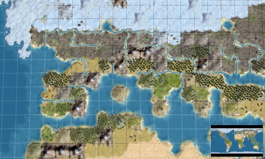
Europe during the Last Glacial Maximum
In Europe, the lower sea levels mean that there is no North Sea and no Baltic Sea. Britain and Scandinavia are part of the continental land mass and, except for the very south of Britain, covered in ice. Northern France and central Europe north of the Alps and the Danube is "steppe-tundra", a semi-arid mixture of grassland and tundra elements, roamed by mammoths and other Pleistocene fauna adapted to the cold. Southern Europe is somewhat warmer and wetter, with scattered forests in moist areas, the only area of the continent where larger human populations can survive.
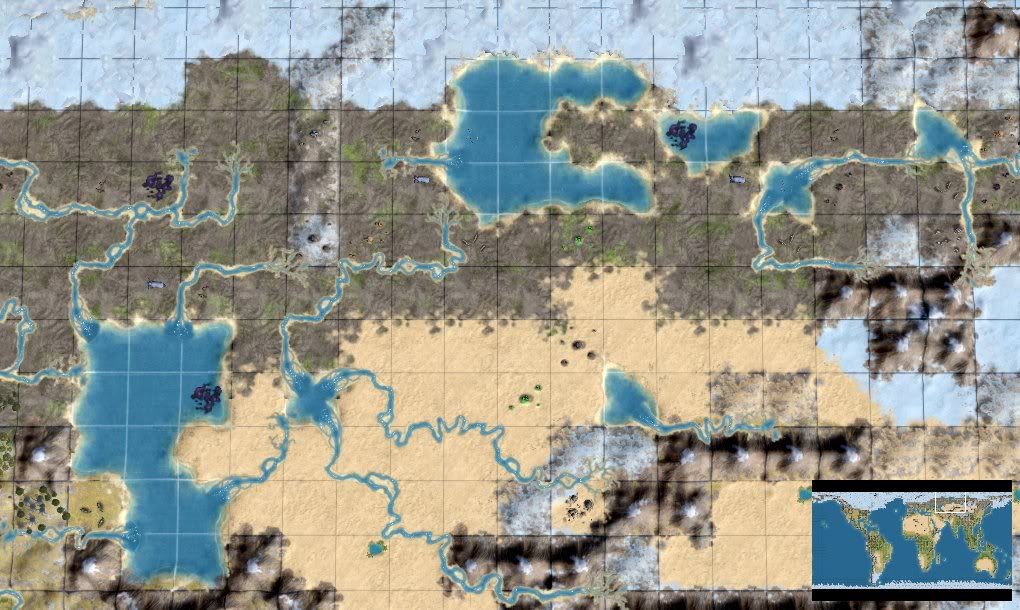
The Western Siberian Glacial Lakes
European Russia, Western Siberia and Central Siberia are steppe-tundra as well. In Siberia, the Yenisei and Ob rivers are blocked by the ice sheet in the north, creating the great West Siberian Glacial Lakes. These lakes, several times larger than the Great American Lakes of our time, form an oasis for mammoths, deer and other fauna. If human civilization ever reaches there, it will find bountiful game to hunt and furs to trade, and later on, the huge Siberian resources of precious metals, coal and oil. Water from the lakes flows through the Aral Sea, the much enlarged Caspian Sea and the Black Sea (which is a freshwater lake during the LGM) all the way to the Mediterranean, creating the longest continuous river system in the world.

The Northern Chinese / Korean plain and the taiga-covered Japanese islands
Central and northeastern Asia is temperate desert or polar desert, depending on latitude and elevation. Either way, it is a dry, barren wasteland where no life can survive. Manchuria is steppe-tundra, passing into warmer steppe in northern China. Because of the lower sea level, Korea is part of the great Northern Chinese Plain, and Japan, covered in open boreal woodlands, is separated from the mainland by only a narrow strait. Southern China has some temperate woodlands and the potential to sustain larger human populations. India is drier than today, with fewer forests and large stretches of open grassland, but still a good place for humans to live. Persia is actually wetter than during the present, receiving enough rainfall for a lake to form in the Dasht-e Lut basin.
The huge Asian peninsula of Sundaland, one of the cradles of civilization
Southeast Asia is greatly changed by the lower sea level: with large parts of the shallow Asian continental shelf exposed, Malaysia and Indonesia now form one huge peninsula, called Sundaland. The eastern and western coasts of Sundaland are tropical rain forest or tropical dry forest and the interior consists of vast grasslands. It could be one of the cradles of civilization in this inhospitable age. Across some narrow straits and islands lies the great continent of Sahul, where Australia, Tasmania and New Guinea have marged because of the lower sea level. A large, extreme desert lies in the center of Sahul, but unlike Australia, the continent features enough tropical forests and grasslands in the north to sustain large-scale agriculture and civilization.

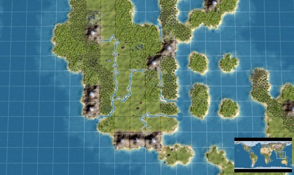
Sahul, where Australia and New Guinea have merged into one big continent
Africa is cooler and much drier than at present. The Sahara desert and the Namib desert are enlarged, and much of the tropical rain forest has been replaced by savanna. The same goes for the South American rain forest, which is divided into two parts by a large belt of grasslands. There is a hot central desert east of the Andes, and the southern tip of South America is cold desert.
In North America, the Laurentide ice sheet covers Canada and the northern US. Alaska is polar desert with some patches of tundra. Most of the Eastern US is taiga forest. The Great Plains are a temperate steppe grassland, populated by mammoths and American horses. The southwestern US and Mexico is actually wetter and more habitable than today, its deserts replaced by tropical woodlands.
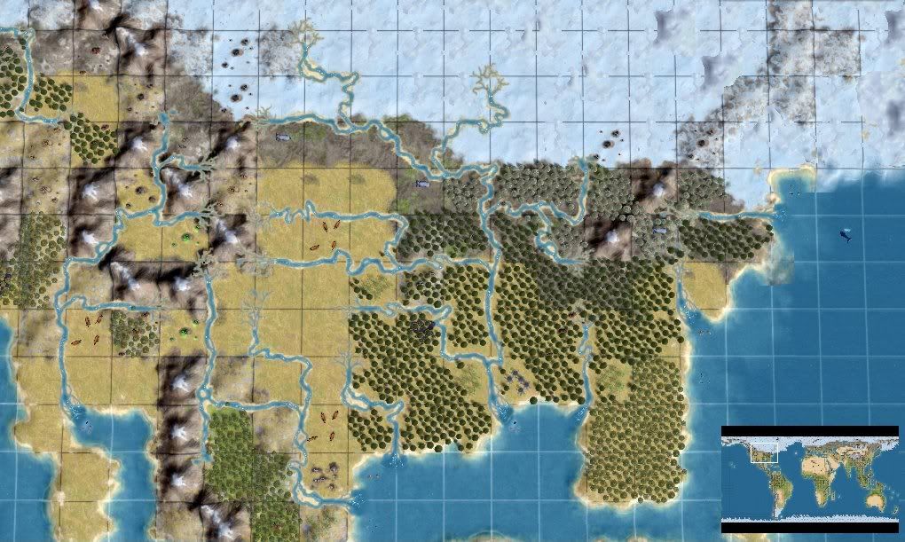
North America with the great Laurentide ice sheet
The consensus among scholars today is that the Americas were only settled by humans after the Last Glacial Maximum was over. This is reflected in the 8 civilizations version of my map, where 8 civilizations are set up in starting locations in Africa, Eurasia and Oceania, with no humans in the Americas. Some scholars used to argue for a "Solutrean hypothesis", the idea that humans from Europe crossed the Atlantic during the ice age, using boats and walking across the frozen ocean, to become the first American settlers (there is a documentary about this theory titled Ice Age Columbus). The theory has been discredited by DNA research and other means, and I don't believe that it is true. But I have included a version of my map with 12 civilizations already set up, 4 of them in the Americas. Given that there were horses living in the Americas during the LGM, which could have been used as labour or for warfare, an ice age civilization in the Americas offers some interesting alternate history pathways!
Inside the .rar archive:
There are nine maps inside this .rar archive. Three for basic Civilization IV, three for the Warlords expansion, and three for the Beyond the Sword expansion. For each version of the game, there is one "blank" map with no civilizations set, one that has 8 civilizations already set up in the Old World, and one with 12 civilizations in the Old World and the Americas (the "Solutrean hypothesis"). In Beyond the Sword, the 8 civilizations for the Old World are: Chinese, Ethiopian (representing the Australian aborigines), Indian, Khmer (in Sundaland), Malinese, Sumerian, Viking and Zulu. The 4 civilizations in the Americas are: Aztec, Celtic (representing the Solutreans who have crossed the Atlantic), Incan and Mayan. In the map versions for basic Civilization and the Warlords expansion, I had to replace some of these civilizations with others, for instance, the Zulu with the English.
To use the maps, you need to extract the appropriate files to the appropriate PublicMaps folder. For basic Civilization IV, extract the *.Civ4WorldBuilderSave files to the PublicMaps folder inside your Civilization IV directory. For Warlords, extract the *.CivWarlordsWBSave files to the Warlords\PublicMaps folder. For Beyond the Sword, extract the *.CivBeyondSwordWBSave files to the Beyond the Sword\Public Maps folder.
")