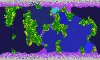
I have successfully completed two tests. Two versions of the maps are shown below.
Both of these maps were created using the archipelago (snaky continents) map script on gigantic(?) size. Currently, this happens to be my favorite script. Sorry about the low quality pictures but I had to get a size big enough where the numbers were drawn and then shrink the quality down until I got a file small enough to upload...
TEST 1
First is the large body map. This shows the major bodies of water that were separately identified in different colors:
NOTE: smaller bodies that appear in the second map below have a separate body id (the number). However, smaller bodies are linked to the larger bodies shown in the above map by the large body ids. (There are more ids in the next image).
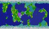
Second is the body detail map. The numbers shown here are small body ids (where applicable). This image is color coded by the body type:
DARK BLUE = OCEAN
TEAL = SEA
VIOLET = GULF
BLUE = BAY
LIGHTER BLUE = STRAIT
LIGHTEST BLUE = LAKE
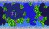
TEST 2
Same format as above...
First is the large body map. NOTE: I just figured out why the red "small body" zone is not attached to an ocean. It is because the only body it is adjacent too is a polar body of water which is treated as a minor body until the very last step. I will have to fix this.
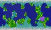
Second is the body detail map. The numbers shown here are small body ids (where applicable). This image is color coded by the body type:
DARK BLUE = OCEAN
TEAL = SEA
VIOLET = GULF
BLUE = BAY
LIGHTER BLUE = STRAIT
LIGHTEST BLUE = LAKE
NOTE: There is a small problem that appears in this map but it is minor. Straights are not supposed to have bays that span the same width sandwiched between the bay and the main ocean but because I also test for gulfs using the number of border plots vs the number of body plots the one in the upper right corner managed to slip through the cracks. I will have to base it on adjacent land area id when I fix this issue.