Bobert13
Prince
- Joined
- Feb 25, 2013
- Messages
- 346
Edit: Here's a link to LamilLerran's updated version: http://forums.civfanatics.com/attachment.php?attachmentid=407307&d=1461956938
Description:
Tectonic Landmasses meet Geostrophic Weather.
Built on top of Cephalo's Perfect World 3 (well, my updated version of it) with code inspired by Tectonic Map Script by Haftetavenscrap and Tectonics by LDiCesare.
Currently, Continents, and Pangea are both working and playable within reasonable measures however as this is the initial release I do consider this a beta.
Installation:
Extract the map script from the archive available here and place it in the following directory:
\My Documents\My Games\Sid Meier's Civilization V\Maps
Configuration:
As with the original Perfect World 3 I have done my best to keep much of the script very configurable via the MainConstants section at the top of the script. Simply open the script with any text editor and go to town. You should find all of these constants to be relatively well commented.
Attachments
-
Planet Simulator.7z33.4 KB · Views: 4,028
-
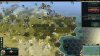
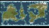 Planet Simulator pic1.jpg247.4 KB · Views: 9,427
 -
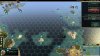
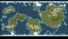 Planet Simulator pic2.jpg239.4 KB · Views: 7,948
 -
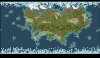 Planet Simulator pic3.jpg242.9 KB · Views: 7,225
 -
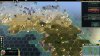 2014-05-28_00001.jpg341.7 KB · Views: 6,444
 -
 2014-05-28_00002.jpg355.6 KB · Views: 5,856
 -
 2014-05-28_00003.jpg318.5 KB · Views: 4,902


