Kal-Els Clean 180x180 Earth: Modder's Paradise

Kal-el

Deity
Joined
Nov 6, 2001
Messages
4,827
Location
Washington DC
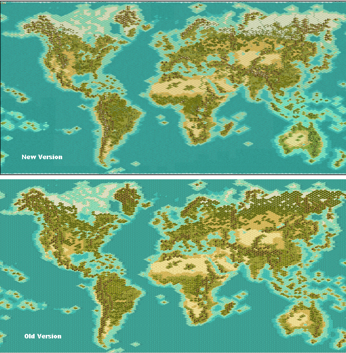
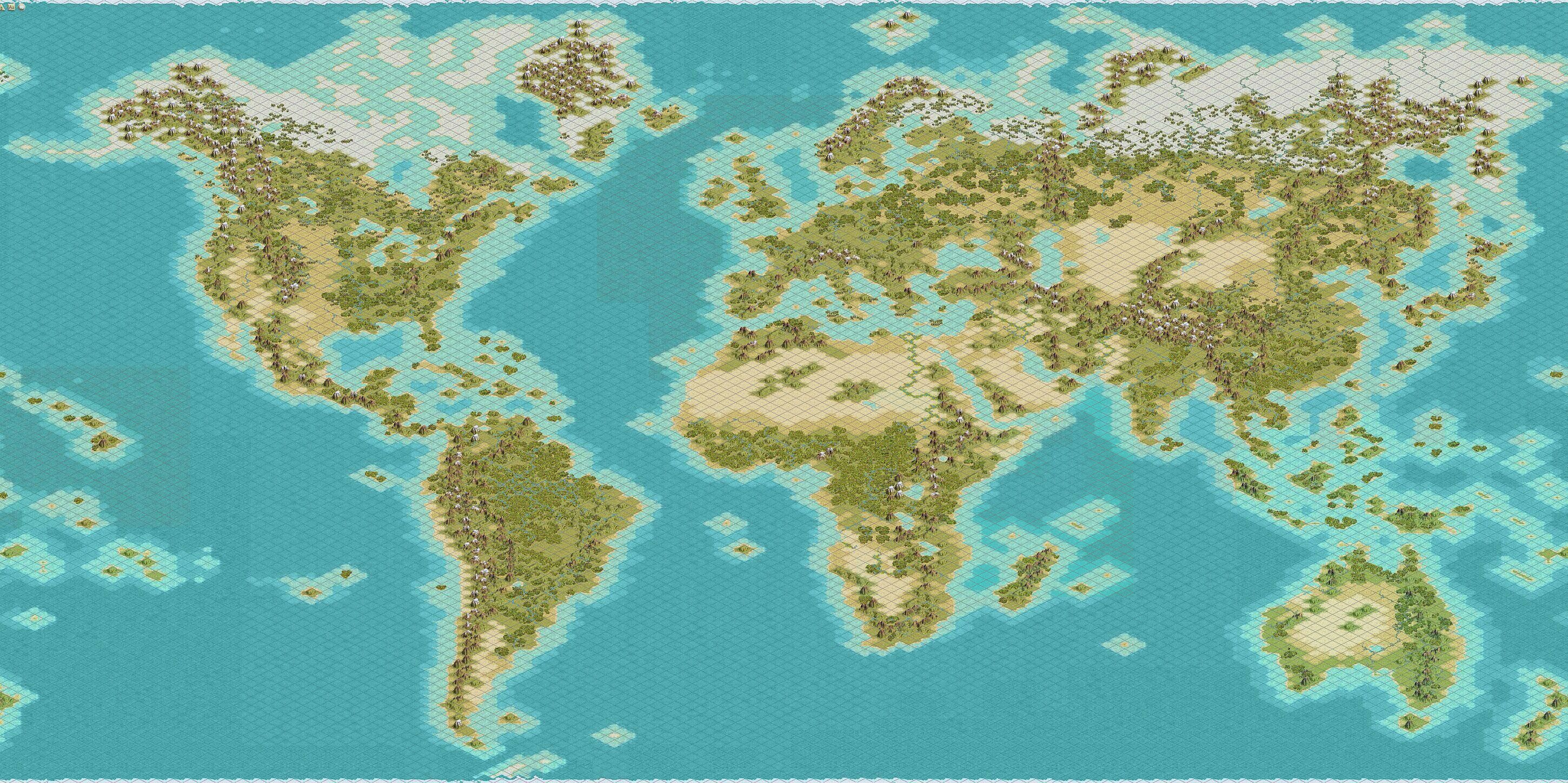
edit: Here is version 2.0 of my map that has no resources, no goody huts, no barbarian camps, and no player start locations.

While not useful for most users, this could come in handy for those of you who want to use it as a basis for your own mods, or for those of you who don't like the resource placement of my original map. :D I know there will be some of you out there. ;)

Anyway, here it is. Enjoy!

A few quick notes:
The land to water ratio on this map is not earth accurate. In order to preserve the detail level I reduced the size of both the Atlantic and the Pacific. It is however impossible to cross either ocean with a Galley without The Great Lighthouse.

Europe has been stretched just a bit eastward into Asia in order to give those civs some more room and to cut down the Asian Advantage.

The British Isles and Japan are both a bit larger than they really should be but that was for gameplay and aesthetic purposes.

North America is bit bigger than it should be but, again, that was for game play reasons.

The Faroe Islands are a bit further over to the East than in real life to prevent an easy crossing to North America.

There are mountains in Greenland to prevent mass colonization of that region.

Also plains and grassland were interchanged where necessary to create a more accurate coastline.

Some areas of desert were made into plains if a river ran through it in order to pevent the mass food production of the floodplain syndrome.

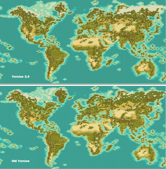
Here is a close up preview:
 
Goodwork! where the map of V1.21f download? ^^

Can Fixed the starting locations ? ^^
 
edit: changes since 1.3
West Coast of North America completely redone
North Coast of North America completely redone
East Coast of North America retouched
More plains in North America
More Jungle in South America
UK is smaller
Iberian Peninsula redone
Reduced umber of Mountains and Hills in Europe
Added Corsica
Removed 1 tile from Crete
Added more jungle to Central Africa
Added tile to Southern Tip of Saudi Arabia
Removed Mountain from the southern tip of India
Added more Jungle to India (the above image doesn't show it)
Added more mountains to central Asia
Removed some hills in China
Reduced the forests in Siberia and Northern Canada
Pushed the tundra line further south across northern Asia

I think thats it. :)


Comparison image of version 2.0 and 1.3 using Gramphos' Multi-Tool


version 1.3 removed after 123 downloads
 

Attachments

  • kal-els clean 180x180 earth v2.0.zip
    45.8 KB · Views: 1,267
Looks good Kal-El. I will probably use a modified version of your map in a scenario idea I have for when the new editor is released. Of course, I'll be sure to give credit where credit is due. :)
 
Originally posted by Kal-el
your welcome. :D what type of mod are you planning on using this for?

Thanks :rolleyes: So I think the mod using modern time for New World War? :D
 
Go here to see an image with a greater magnification so that you can see the details a bit better. The image is of version 1.2 of the map and since that point there have been some minor modifications to some mountain ranges and the forested areas were cut back a bit to allow for resource placement. But the 1.2 image gives you a very good idea of land mass and shape. Those were not changed.
 
Ok, well after many promises, I can finally say that real progress has been made. I have been able to rework some major areas that were nagging at me.

Specifcally:

I have done an overhaul of the west coast of north america,
shrank the great lakes a tad,
redid florida and parts of the atlantic seaboard,
did some work on South America,
decreased the hospitibility of Greenland,
shrank the British Isles a bit,
moved the faroe islands west,
adjusted the western coast of europe a bit,
did some work on the central europe,
added some more jungle in the congo,
did some work on the himalayas,
deforested siberia.

I think that covers most if not all of the changes. I may have missed soemthing minor here or there. These changes vastly improve the overall look of the map.

I will put some previews together soon and post them so you can get a better idea what the new version of the map will look like.

I may also put together smaller versions as well, but these things take a lot of time. I am thinking of doing a 160x160 version and possibly a 140x140 version. Anything smaller than that and I think I would just be frustrated by the lack of detail.
 
Kal-el, tell me:
is your map a handmade work? Or is it converted from some projection? The northern emisphere is quite similar to Canter's, but not the southern
If it is an handwork, take a look to Robinson or Winkel-Tripel projection to make the work perfect.

Uh, a suggestion:
instead of putting hill and mountains in greenland, just set 0 food on tundra: it will also prevent AI from colonizing Siberia and northern Canada
Another suggestion: it's better to have 4 ocean tiles between Alaska and Kamchatka and Scotland and Iceland. That's because the Great Lighthouse should not be enough to discover new lands (America discovered 300BC????)
A last suggestion: Atlantic seems too shrinked, it could be a good idea to move South America 1 tile to the left (I could do it if I knew what program to use)


And, how long are we going to wait for the new version?
I'd love to put resources and start playing, as I think it's probably the best map (Marla Singer's is too big and I don't like Miller's projection); but if you're going to come out with a new version (I hope 160x160) I would have to do it again!
 
Originally posted by Rhye
Kal-el, tell me:
is your map a handmade work? Or is it converted from some projection? The northern hemisphere is quite similar to Canter's, but not the southern
If it is an handwork, take a look to Robinson or Winkel-Tripel projection to make the work perfect.
Rhye, I'll tell ya. This map was all my own. I am not familiar with Canter's map but would be very interested in seeing it.

Uh, a suggestion:
instead of putting hill and mountains in greenland, just set 0 food on tundra: it will also prevent AI from colonizing Siberia and northern Canada
That won't stop the AI from settling the area, it will just cause those cities to starve to death. The only way to stop the AI from settling an area is to set it as unsettlable in the editor. I did that for my own mod, but this map is for other modders to use. Regardless I have added a lot more tundra to Greenland in the latest version of the map. Have you seen the latest preview of the map?
Another suggestion: it's better to have 4 ocean tiles between Alaska and Kamchatka and Scotland and Iceland. That's because the Great Lighthouse should not be enough to discover new lands (America discovered 300BC????)
Again in the latest version of the editor you can set the movement costs of ocean and sea tiles to be greater than 1. I suggest you do this.
A last suggestion: Atlantic seems too shrinked, it could be a good idea to move South America 1 tile to the left (I could do it if I knew what program to use)
It has been shrunk quite a bit. All the oceans are smaller than they should be in order to have larger land masses which allows for greater deatail.
And, how long are we going to wait for the new version?
I'd love to put resources and start playing, as I think it's probably the best map (Marla Singer's is too big and I don't like Miller's projection); but if you're going to come out with a new version (I hope 160x160) I would have to do it again!
I will probably releasea the clean version of the map by this weekend. I don't think I will release a standard civ3 resource version, I will let you guys do that.

The next map will be 140x140. I am going to try and use the bmptobic tool to convert this map. That tool only allows certain map sizes so 160x160 is out for now as that would mean I would have to start from scratch again! I have been through that once, I am not interested in doing that again any time soon.

I am attaching an image that compares the current version of the map with the new version of the map that is under construction.
 
Good, I see more tundra and jungles. Tundra WITHOUT any kind of forest is important for stopping AI colonization in that regions.
If I were you, I would reduce hills in Europe
And I think China is too "fat".

BTW, how do you make those screenshots?
And where do you find BMP to convert with BMPtoBIC? I'd like to make a different projection (maybe one day)
 
Here's something that may be useful:


1) Mercator's projection (the worst)
 

Attachments

  • mercator1.gif
    mercator1.gif
    37.3 KB · Views: 2,064
Top Bottom