Map: United States East Coast

Jon Shafer

Civilization 5 Designer
Joined
Jul 14, 2002
Messages
2,102
Location
Maryland
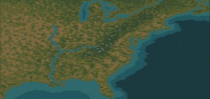
Since "the" editor is coming out soon, I figured that since there was an extreme lack of good maps of the eastern US for Revolutionary and Civil War scenarios (ones I want to do ;)), I decided to make one.

I will post a demo of the .BIC I'm working on now (just the outline of the coast and rivers, so far), in case anyone wants to take a look. I'm going to make another post and put up a picture for everyone to see how it's going (without having to download it).

[Edit]More updated version of the map... I'm almost done! :D[/Edit]

Alright, I believe I may be finished with the map, unless someone has some terrain tweaks for me. :)

Feel free to use the map for whatever you like, but if you make it into anything that you release to the public, make sure you give me credit for it. ;)

Version 1 (without default rules, forgive me :o) replaced after 14 downloads.
 

Attachments

And here's a current screenshot, terrain-free. ;)

[Edit]A new screenshot, terrain included this time. ;)

I have added the Mississippi, Missouri and Ohio rivers as coastal tiles in order to allow units to navigate them.[/Edit]
 

Attachments

  • minimap9.gif
    minimap9.gif
    35.9 KB · Views: 1,855
Alright, I'm almost finished. I changed the shape of Florida a bit, and added all of the terrain. All rivers are included (but they don't show up
ugh.gif
). I'm debating on whether or not to make the St. Lawrence continuous all the way to Lake Michigan (like it is now), but then units won't be able to cross over... So the issue is whether to allow naval units to pass through or to allow land units to get through. What do you guys think?

Also, if anyone knows the terrain better than me, please give me some guidelines. Figuring out what the real terrain looks like is an iffy job at best, so some expert knowledge would be appreciated. ;)
 
you should make the mississippi and misoury rivers navigatable just like St. Lawrence. Afterall ships can sail on them, right?
 
Originally posted by Stormbringer
you should make the mississippi and misoury rivers navigatable just like St. Lawrence. Afterall ships can sail on them, right?
Again though, that brings up the same problem as the St. Lawrence. No troops will be able to pass over the Missouri/Ohio/Mississippi if I make them into coastal tiles. If I leave "1 tile" for a city to be built upon, you can't count on that, and the problem still remains that no troops can cross anywhere but where there's a city. Therefore, it will only be useful for scenarios and not for people who just want to play on the map.
 
well, I am fine with that ;) A group of cavalry, or anything else can't really cross such a big river without boats now can they? A new type of boats could be added. Very cheap and slow, but carry two and sink in oceans and seas. Used later in the game to transport units on rivers.
 
Originally posted by Stormbringer
well, I am fine with that ;) A group of cavalry, or anything else can't really cross such a big river without boats now can they? A new type of boats could be added. Very cheap and slow, but carry two and sink in oceans and seas. Used later in the game to transport units on rivers.
Works for me. :)

Now all I have to do is find an appropriate graphic for it. :p
 
For the Mississippi river, you would have it navigable but in some places have land crossings. I was thinking for some of the great cities like (St. Louis, New Orleans, and Chicago). It isn’t accurate but I think it is playable. I only can back up Chicago though where I know that the river starts to get smaller and isn’t that much of a river so please take this into thought.

“The Mississippi is only navigable because of the many docks”
I made it up. what?
 
well I would be glad to help, but I cannot make any graphics. :( 
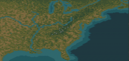
Anything I can do to help? I really like the map
 
:lol:
I'll just make a cheap "Ferry" unit that can move 2, transport 2, sinks in sea and ocean. I'm almost done converting the Mississippi and Ohio Rivers... any others that you think are worthy of navigation by vessals? :)
 
Misoury? I know I spelled it wrong
 
Trip that sounds good too. I plan to change it as soon as I get it but I will still have those ferry units. That is a good idea. I want to make a somewhat not historic scenario out of your ideas of your scenario of the French losing its colonies of the Mississippi to the native Indians and France also having to fight a war with Britain.

Well hope you get all the units and techs rallied up so it will be easy for me. You going to do that?
 
Here it is.

Not sure about the Missouri... I may change it, and I may not, we'll see.
 

Attachments

  • minimapcoast.gif
    minimapcoast.gif
    36.3 KB · Views: 1,711
the crossing idea is not good. This is not civ2 where you can cross the river at the crossing with both ships and land units....Well, anything else I can do?
 
No you dont understand when there is a city a ship can pass though it and go to the other side of the land. So by creating land gaps you can have 1 or 2 citys that are the lannd gaps. Both a sea and land unit can go inside a city. Do you understand now?

Just telling you it works but I like the ferry also, but what is you dont have boats because you dont like boats.?
 
Naw, I should be able to finish things up on my own now. Thanks for your interest, I'm glad someone cares! :D

Right now, I'm trying to fix the location of the rivers (if you look closely, Illinois is about as big as Texas ;)).
 
yes, Ohio is a little bit too far to the south.....Well, if you need playtesting or anything just tell me. I will be glad to help. On the cities....there is no garantee ai will build the city in the gap, that is the only problem with your idea
 
I stand corrected. I was thinking scenarios. It could be a simple change for that.
I want to know how people make maps so fast. Didn’t you start yesterday Trip? It took me about 5 days so finish my two maps I made and they were smaller then yours.
 
It takes a long time to do, but I had nothing to do today so I decided to fill the thing in. :)
 
Back
Top Bottom