Kal-el
Deity
Kal-els 180x180 Earth Resources v1.0 Readme.
This map is my atttempt at creating a fairly accurate world map of 180x180 proportions. I am hoping that this size map will alleviate the long waits that can be seen on some of the larger maps.
Unlike other maps that used either a Millers Projection or even Mercators which tend to distort the shapes of the land masses the further towards the poles the land mass is, I used separate projections for each of the continents and then combined each of those projections into one single image. This process helps to alleviate the distortion of land mass shape and ensure that the outlines of the continents remaines as true to life as possible within the limitations of converting a round shape onto a flat surface. The process of combining the multiple projections has a draw back in that is distorts some distances across bodies of water and the areas where the continents meet are also often times distorted. The land to water ratio on this map is not earth accurate. The map is 66% water. In order to preserve the detail level I reduced the size of both the Atlantic and the Pacific. It is however impossible to cross either ocean with a Galley without The Great Lighthouse.
In addition I took some liberties with the comparitive size of the continents. This was done mainly for gameplay purposes. As a result Europe and North America are larger than they are in Real Life. Likewise the Island nations of the United Kingdom and Japan are both larger than one would expect on a completely accurate map. Because of these changes other areas were reduced in size.
To make room for an enlarged Europe which has been stretched just a bit eastward into Asia in order to give those civs some more room and to cut down the Asian Advantage. Africa was also shrunken to accomodate Europe and to reduce the advantage that civs starting on this continent have over other civs due to the vast open expanses.
South America was also reduced in size for mainly the same reasons that Asia and Africa were.
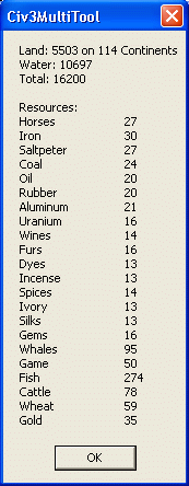
I tried to place the resources as accurately as possible. For gameplay purposes I limited myself in the total number of Strategic and Luxury resources on this map. Using 16 players as base reference, as that is the default number of players for a map of this size. I then calculated the number of strat resources that should appear based on the standard appearance ratios given in an unmodded Civ3mod.bic file. I was not completely true to these numbers but I did use them as a point of reference. To determine the number of Luxury resources I looked at several randomly generated maps and discovered that the random resource placement tends place a number of Luxury resources totallying 75% of the number of number of civs available, i.e. if 12 civs are playing the total numberof luxury resources will average eight of each luxury resource.
A few quick notes:
------------------
The Faroe Islands are a bit further over to the East than in real life to prevent an easy crossing to North America.
There are mountains in Greenland to prevent mass colonization of that region. I recommend that you set tundra as unsettlable.
Also plains and grassland were interchanged where necessary to create a more accurate coastline.
Some areas of desert were made into plains if a river ran through it in order to pevent the mass food production of the floodplain syndrome.
I also took some liberties with resource placement on two major points: 1) I put iron in Japan for their UU, and 2) Horses in North America for the Iroquois UU.
Kal-els 180x180 Earth Resources v1.0.zip contains 2 files:
----------------------------------------------------
1. Kal-els 180x180 Earth Resources v1.0.bic
2. Kal-els 180x180 Earth Resources v1.0 Readme
I hope you enjoy playing on it as much as I enjoyed designing it. If you have any suggestions you can contact me at dickjensen@hotmail.com or through civfanatics.com. This map was created by me, Kal-El, October 2002.
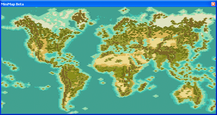
The Minimap Preview:
Resource Dispursement:
Here is a close up preview: The map has seen some changes since this larger preview was made
This map is my atttempt at creating a fairly accurate world map of 180x180 proportions. I am hoping that this size map will alleviate the long waits that can be seen on some of the larger maps.
Unlike other maps that used either a Millers Projection or even Mercators which tend to distort the shapes of the land masses the further towards the poles the land mass is, I used separate projections for each of the continents and then combined each of those projections into one single image. This process helps to alleviate the distortion of land mass shape and ensure that the outlines of the continents remaines as true to life as possible within the limitations of converting a round shape onto a flat surface. The process of combining the multiple projections has a draw back in that is distorts some distances across bodies of water and the areas where the continents meet are also often times distorted. The land to water ratio on this map is not earth accurate. The map is 66% water. In order to preserve the detail level I reduced the size of both the Atlantic and the Pacific. It is however impossible to cross either ocean with a Galley without The Great Lighthouse.
In addition I took some liberties with the comparitive size of the continents. This was done mainly for gameplay purposes. As a result Europe and North America are larger than they are in Real Life. Likewise the Island nations of the United Kingdom and Japan are both larger than one would expect on a completely accurate map. Because of these changes other areas were reduced in size.
To make room for an enlarged Europe which has been stretched just a bit eastward into Asia in order to give those civs some more room and to cut down the Asian Advantage. Africa was also shrunken to accomodate Europe and to reduce the advantage that civs starting on this continent have over other civs due to the vast open expanses.
South America was also reduced in size for mainly the same reasons that Asia and Africa were.
I tried to place the resources as accurately as possible. For gameplay purposes I limited myself in the total number of Strategic and Luxury resources on this map. Using 16 players as base reference, as that is the default number of players for a map of this size. I then calculated the number of strat resources that should appear based on the standard appearance ratios given in an unmodded Civ3mod.bic file. I was not completely true to these numbers but I did use them as a point of reference. To determine the number of Luxury resources I looked at several randomly generated maps and discovered that the random resource placement tends place a number of Luxury resources totallying 75% of the number of number of civs available, i.e. if 12 civs are playing the total numberof luxury resources will average eight of each luxury resource.
A few quick notes:
------------------
The Faroe Islands are a bit further over to the East than in real life to prevent an easy crossing to North America.
There are mountains in Greenland to prevent mass colonization of that region. I recommend that you set tundra as unsettlable.
Also plains and grassland were interchanged where necessary to create a more accurate coastline.
Some areas of desert were made into plains if a river ran through it in order to pevent the mass food production of the floodplain syndrome.
I also took some liberties with resource placement on two major points: 1) I put iron in Japan for their UU, and 2) Horses in North America for the Iroquois UU.
Kal-els 180x180 Earth Resources v1.0.zip contains 2 files:
----------------------------------------------------
1. Kal-els 180x180 Earth Resources v1.0.bic
2. Kal-els 180x180 Earth Resources v1.0 Readme
I hope you enjoy playing on it as much as I enjoyed designing it. If you have any suggestions you can contact me at dickjensen@hotmail.com or through civfanatics.com. This map was created by me, Kal-El, October 2002.
The Minimap Preview:
Resource Dispursement:
Here is a close up preview: The map has seen some changes since this larger preview was made
