New Border Proposal - Plan C

Goonie

Lonely End of the Rink
Joined
Nov 29, 2002
Messages
3,312
Location
Kingston
New Proposal!
This proposal caters to those who voted no on the former proposal. This takes their suggestions and puts it into the proposal.

Gem_Mountain_Proposal.gif


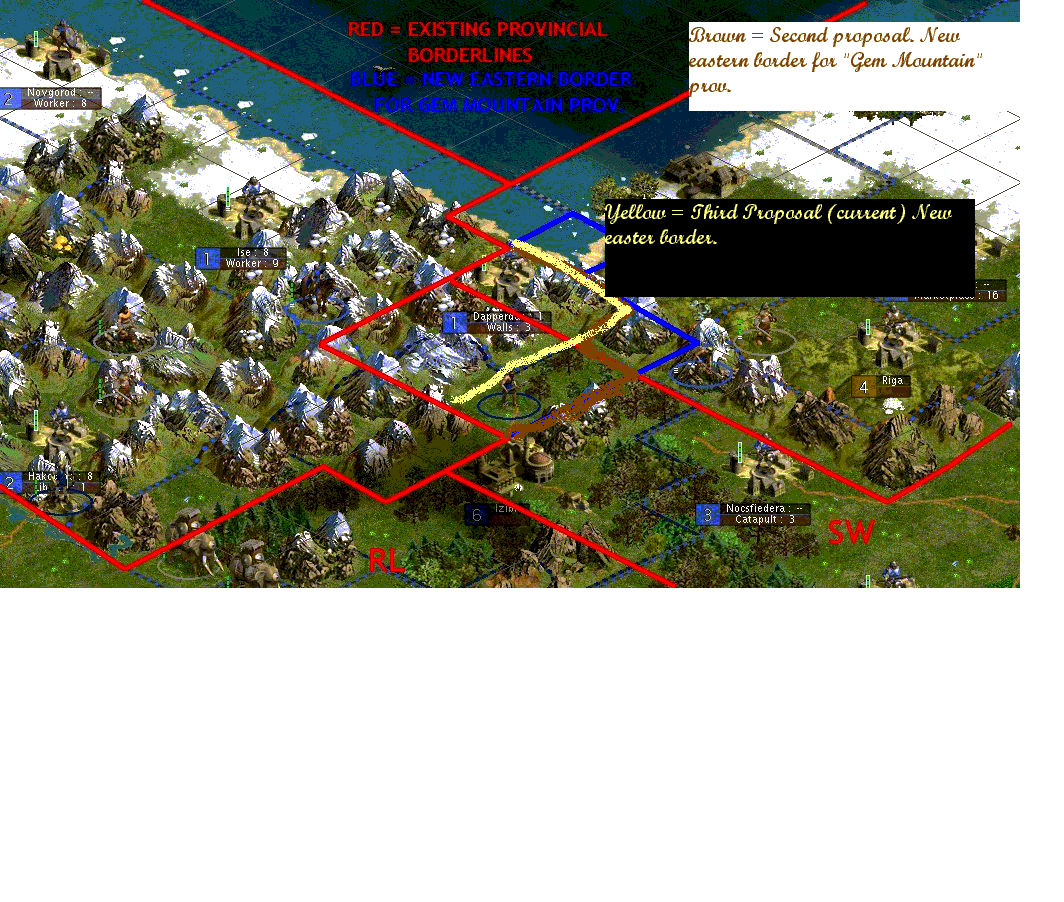
Some people have said that borders have to follow terrain. This proposal does just that. Here is another picture that makes it simpler.

Gem.gif
 
A little better... :)
 
I can't even read it, but it has been explained to me in enough detail that I will support it.
 
Basically, the yellow line is what I think the new border should be.
 
I still vote no. I can see you getting the 4 Mountain Tiles from the SW Province, but that's it.
 
As I supported the last one. I will support this one.
 
Ill support Goonie on this :).
 
This time I'll stand by you.
 
Originally posted by Cyc
I still vote no. I can see you getting the 4 Mountain Tiles from the SW Province, but that's it.

CYC. Taking the whole square(including Dapperdan) is following the natural lay of the land. This proposal is trying to right a wrong. Borders follow terrain. Something went wrong with this border and it has to be fixed! My second picture is what I am talking about!
 
Look at my second image Shaitan. I am taking the whole square and nothing but the square.
 
It is now the Province of Montis abeo Gramen!
 
Yes. Yellow is the current proposal. Plan C!
 
It still doesn't work, Goonie. You are still taking the end of the Spine in your grab for Dapperdan. There is still absolutely no call for Dapperdan to be part of MAG province. There is no geographical reason to toss a hill tile to the end of 4 mountain tiles when the adjoining hill is in another province. There is also no way that you can realistically argue that a city that abuts one province at hills and coast would owe it's allegiance to another province that only abuts mountains to it.

Take the mountains from SouthWest - I agree that those should go over. Stop trying to steal Dapperdan.
 
You could also argue the mountain to the SE is still part of Gem Mountain (the group of mountains :)). I just don't what the big deal over border redistribution is in this game...
 
I had a look at the map as Shaitan suggested.
And as I see it the yellow border is the border which fits the terrain best. I too support Plan C.
 
Back
Top Bottom