Final Earth Map

Marla_Singer

United in diversity
Joined
Oct 24, 2001
Messages
13,338
Location
Paris, west side (92).
NOW ADAPTED FOR VERSION 1.29f !!

Download the version 1.29f of the map that you can find at the bottom of this message. :)


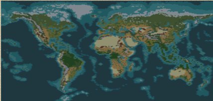
Here's the Miller's projection of the earth. Alaska is near Russia and sizes are almost respected (it's NOT Mercator's projection where Greenland is as big as Africa, here, Greenland is around 16 times smaller than Africa). The Bering Strait is a strait, Italy looks like Italy (even if Sicily is really tiny and connected to Italy), there's islands in the pacific ocean (marshall islands, polynesia, etc...).

Civilizations birthplaces are in the same place as in reality which creates a little problem because european civilization are fighting to create new cities as firsts (some place is missing when we play with 16 civilizations).

I've also placed barbarian camps and goodie huts where there's the most people today and also in historical place such as Jerusalem, Mecca, the Incans or Scandinavia. To decide if it was a goodie hut or a barbarian camp, i've just cared about distances between it and a civilization birthplace. Just to avoid barbarian invasion that doesn't let us time to create our first warrior.

Each ressources are placed like in reality. As my knowledge about it isn't infinite I would like people to tell me about it to make changes for a later version.

I've placed ocean/sea/coast regarding to the depth of the seas in the real world. It's pretty fun cause we can reach Canada through Greenland from Europe using Galleys as did the vikings. We can reach caribean islands from Europe using Caravels as did Christopher Colombus. And we must wait galleon to explore south Pacific Islands as did James Cook.

Civilizations are growing in a pretty realistic way. Russia is going to the east because there's too many people in Europe. France go to Spain, Germany to central Europe, China (Beijing) goes to the south or Japan goes in the pacific islands. I've put wheats and cattles in the places where there's today the most humans. That means mainly Europe, China and India, but also, the east of the US, south american east coast, Nigeria, North Africa, south east Australian coast.
:crazyeyes :crazyeyes :crazyeyes

About my critics now :(
Europe is very small and in the fight to found new cities, Rome is often the loser. Japan and England wait centuries to start to devellop to get out of their islands. Computer civilizations never declare war between each other, I guess that comes from the AI and I've nothing to deal with, but it's pretty boring to see so much pacifist people.

Only few civilizations can build the Iron works small wonder. (Germany, France, England, America, Iroquois and China). What else to say... well that's all... I'm waiting for your critics !


write me soon.
:egypt:

Oh, by the way, it's really boring cause we cannot go to the black sea from the mediterranean sea like we used to do in Civilization 2. Regarding to history, it's not weird to think that boats and pedestrians can cross that area. I tell that because Japan and the UK are really penalized cause they must wait trireme to get out of their islands. It would be easier to join also Gibraltar and Sweden with Denmark.

Latest version: Marla Singer's World Map 1.29f
(version 1.05 removed after 1394 downloads)
(version 1.085 removed after 1279 downloads)
(version 1.10 removed after 452 downloads)
(version 1.13 removed after 4927 downloads)
(version 1.17 removed after 2239 downloads)
(Version 1.18 removed after 7791 downloads)
=> it works now with 1.17f version of civ3


NOW ADAPTED TO 1.29f VERSION OF CIV 3

Each civilization is automatically at its correct location.
Civilizations can't build anymore cities on tundra and on desert. Colonies can be build to get ressources.
 

Attachments

  • marla singer\'s world map 1.29f.zip
    80.1 KB · Views: 31,878
Here's a little snapshot of my map. I know it's a small picture, but we can't find better with that version of civilization.
 

Attachments

  • worldmap.jpg
    worldmap.jpg
    18.1 KB · Views: 68,799
Thanks Marla.

The snapshot looks really great. Haven´t tried it yet though. But I have downloaded a couple of maps. i.e. Stayas. Had to make some changes to it before I could play it.
Since I´m at work know I have to wait a couple hours before I can try it. Will be bake with feedback.

But I have to object to your idea of letting the English and Japanese be connected to mainland. No way. That would´nt be historic. They simply have to build galleys and make colonys.

When my girlfriend calmes down (she´s a bit upset that I spend least four hours each night with civ3) I´ll start with my own world map or perhaps smaller parts like Scandinavia or Europe.
 
Well I guess you're right it's more accurate regarding to history and finally both civilizations (the one located in Japan and the other in the UK) can handle with it in my tests. :crazyeyes But I'm sure I would never take them to start to play !! :D

Well, while playing to the v1.02. I've discovered a tech rate at 300 is a lot too slower. I've put it now at 200 so I hope it will help but I haven't tested it. I've also put the optimized number of city at 32 instead of 50... maybe it was a wrong choice, if you want to change it, go in the editor, then select "world size", choose then "tiny" (that's the map I've edited to create my map) and then, put the optimized number how you want.
32 cities without any corruption issues is enough I guess.

Now about changes, I've listened to you guys and I've reduced the number of barbarian camps and increased the number of goody huts. We must not forget that we play at 16 in there so everyone must be served. I've done so to promote exploring, especially in places such as Indonesia, the atlantic ocean or Africa and South America.
I've also done some small other changes, look at the readme to see them. :)

Version 1.08: Before everything, ressources have been rethought.
But also, African and American great lakes sizes have been decreased. Jungle has been mixed with forest in places the most densed in population today (Indonesia, Malaysia, Congo River, Manaus (Brazil))

:hammer:
:flamedevi

I will always write latest changes in this post so that it's easier to find them in the thread.
 
I haven´t seen your map yet because I am at work at the
moment but I am afraid of such huge maps because games
there last for ever. I would like to have a world map
approximately the size of the classical one in Civ1, I do
not remember now its exact size. When I have the time
I will work on it.

Also, I suggest everybody to work out
maps using a trasparent paper with a grid painted in it
and a real map in a book for optimal accuracy. It takes
a long time but it is the only way to do things really well,
putting rivers, mountains, hills and forest in its very correct place,
and remember a good map is better than a handful of bad ones.

I only created two maps for civ2, one of Europe and another one of Spain, both of them needed a long time and are very accurate. I have tried to convert both of them to civ3 but I do not know how to ask the editor to create a map of a given exact size. Any help will be welcome.
 
Well, you don't know what ? I've used a transparent paper with a grid... well it's not a transparent paper, it's just paper with squares and a so poor quality that we can see through it the shape of the map behind. The map has been redimensioned to look proportionate in the game.
I've made some changes especially in Europe to make it a bit bigger and to make of the british isles actually islands. Italy has been also changed because it was too tiny and it really wasn't fair for romans.
About, forests in a map at their "accurate" place. You must know that in 4000 BC there's 95% of the ground occupied with forest in the whole america, in the whole europe and in a big part of Asia... if you want I can make such a map but I didn't think it was really fun to play with such a map (some can think it is)
Other thing, I've got some issue for some terrains doesn't exist in the game. For example, I've decided to mix forest and plains to create savanna. Plains are mostly semi arid places, deserts are deserts, temperate and continental climate are mixes of grassland and forest. Tropical is a mix of grassland and jungle, Equatorial is pure jungle.

However, I'm posting messages because I want to hear some critics, so if you think there's not enough mountains here or there or in the whole map or whatever you want, I would be pleased to hear your advice about it :). So go on, I'm open. :D
 
Hello again, I am at home and I have seen your map. If you
want it in a single word: excellent :) When I have had a better look at it I will suggest you some minor geographical changes
and about the location of certain resources. Congrats on
your map and thanks for sharing it with us.

Would you consider to create a smaller version of it? That
would be fantastic for us who are afraid of endless games
in huge maps.
 
I love this map... its is the best I've seen. Very well though out. I changed one thing though I took out a chunk of turkey so there is only one land bridge from greece to turky so if someone decided to make a city of constantiople than they can use the black sea. other than that I haven't had enough time to really throughly go over it, but from what I see I love it.

(Since this post I have made a few more changes... it seemed like there were too many barbarian camps and not enough goodie huts... the goodie huts were only around the civs whuch seemed to discourage expantionist civs and exploration... so I lessed the barbarian camps by 33% or so... and addded some goodie huts where they might make sence (i.e. inca has both 3 barbarians and 3 goodie huts.)

hopefully I'll be back with some more helpful suggestions soon.
 
Next362, you're so right when you say that there's too many barbarian camps and not enough goody huts. I've tried to switch the balance to promote exploration especially in places where we wouldn't like to explore, such as Indonesia, Africa... I've posted my answer before so I won't repeat it. It's in the latest changes post. :)

Civilizator, I definitly agree about how much that game are eating our free and sleep time. I don't have anyway to make the map smaller easily, I've heard about utilities to do so, if someone know how to do that in 5 minutes, it would be great to post that version. :) I've reduced the tech rate from 300 to 200 so now game should be shorter. Actually, there's a lot of ocean in my map so it's not that big... well it's big but not that big. ;)

I would like also to thank Thunderfall who put my map in the main page !!! THANX ! I was so proud to see my map when I've just typed www.civfanatics.com :D

I swear I'll post less messages to let other people talk, but I can't think about anything else but that map for the moment, especially because I'll have to work hard for the university in next monthes so I wouldn't have as much time as now then.
 
One thing I've done is removed all the Barbarians from Aulstralia and replaced them with goodie huts only (ie since the aborigines never really resisted). but added barbarians in areas like mongolia/centeral asia where constant destructive invasions thru out history originated (Xiongnu[early mongols], Yue Qi, Kushans, Hunas, etc.) also in the Caucaus Mtn.s for the Huns, Alans, and other euro-asian invaders. personaly im trying to make the map balance to pose simular challanges to civ's in civ3 that a real one would have faced. also using barbarians to discourage exploration in some places like east russia, the congo, and amazon basin till later in the game seems like it might be a good idea.

thats it so far.
thanks for the cool map agian.
 
Thanks for the beautiful map.

i have one question though:
the 'coastal' tiles in the midst of the Atlantic Ocean, shouldn´t this be the deepest part of the ocean???
 
I'd agree on the coastal being used for the ridges. It certainly looks better, but traveling in that area is no less risky than any other place in the Atlantic. That area should still be a vast expanse of ocean that is treacherous to earlier vessals.
 
Actually, the mid-atlantic ridge is shallower than the ocean on either side, so in a sense the map as it stands is accurate. But since there is no semblance of depth in Civ3 it is probably better to put them as Sea tiles instead of Coast.

Also, it was the Atlantic that was crossed before the Pacific ever was (not counting the Bering Strait of course).
 
Hey everyone,

About ridges, according to History, we all agree about the fact that Christopher Colombus crossed the Atlantic Ocean in 1492 with a caravel exploring the west of the Açores. The wind makes him go more in south and he finally arrived in the caribbean islands. In Civ3, there's no wind that lead boat in special places, BUT, caravel can explore seas and not ocean. If we put "sea" instead of "ocean" for the ridges, it appears that a caravel can go in the carribean islands from Europe. So regarding history, it doesn't sound that unaccurate.
Now there's two issues. First, a trireme is enough to explore most of pacific islands... well, I haven't tried yet but I guess it's possible. We can always talk about melanesians who came from Australia to Hawaï using pirogues... but it's true that it's not very accurate. The main issue is that for future scenarios like world war 2, the battle of pacific needs these islands, and these islands have coasts that surround them due to the game.
Now about the deepest part of the ocean which is in my map coastal terrain. Well, the ridge goes out in the Atlantic ocean to form the island of Ascension between Africa and South America. I've just put more coasts to make the map look better and not for accurate reasons. so I guess, that's bad.

Anyway, to create a map, we must always balance three things:
1- The accuracy of real world in proportions and in terrain.
2- The accuracy of the gameplay that lead us to use same ways as in real history (for example, the ridge to make caravels go to the carribean or Spain separated from Morocco by seas even if in proportions, it should be connected).
3- The esthetic of the map (once again ridges but also tundra recovered by forest for Northern Canada or Siberia).

All my little change has been made for that balance cause it's the best way to have an accurate map, and that geographically, and historically.

Now, I've discoverered that an optimized number of cities at 32 pushes all civilizations to create their 32 cities... even if it's on Greenland or small islands surrounded by water in 2000 miles from the capital city. I guess the best would be to decrease the number of civilizations to play with... 16 sounds too much. Well That's your choice, play as you want ! :rolleyes:
 
have you made any mods to the original file yet? anything new? just as a personal request I'd love to see a european map from you... possibly including the medd. and north africa. I'm really looking forward to seeing more of your maps the first was great. :goodjob:
 
Thanks Marla for what looks like the best world map posted.

I have one question. When I have tried playing on it I notice that, as with some other scenarios, the science tech tree is inoperative so that the player cannot direct the course of research. I have tried modifying your mod by going into the editor, selecting 'restore default rules' and saving your map as a new file. But even this fails to fix the tech tree problem. Is it possible to play on your brilliant map without the tech tree problem?
 
been clicking on the link and all I get is attachement.php file instead of Marla's .zip?

Is the link wrong or I'm going mad from civ sleepless nights here?

cheers, keep on goody work :)

edit: ok OIC, one has to rename it to .zip to extract.
 
you dont have to rename it, just associate it with WinZip (or whatever zip program u have) or if ur lazy just right clik and do open with :scan:
 
This is the best map so far.
Even if some of the islands is in the wrong place, it has to be that way if we are suppose to get any at all.
I am testing a game with this map, and even if I only has got to about 600ad and has not explored all the world, it is the best world map so far. I hope you will continue to do upgrades to the map.
 
Top Bottom