The Ultimate Map Thread

Thanks Dance! I'm glad to see that my mapmaking method is reasonably realistic. However, I've got a question of one thing which I don't get.

The Yukon River has a huge marshy outflow where it hits the sea, as do the Rivers Fraser and Mackenzie, all of which are in the northwest corner of North America. Are those not deltas?

Yes you are entirely correct and I made a mistake! Deltas refer to the mouth of the river, I was thinking of flood plains. :blush:

Let me go edit that.
 
Very impressive stuff. If I get chance I might edit this into the first few posts...
 
lots of good information for sure, but:

Earth has a tilt of roughly 23.5 when rounded up, what this means is that the earth is not a sphere that sits there with the pole going straight 'down' in space, but is always tilted somewhat away from the sun. This tilt places the equator in a position so that it always receives sunlight, while areas further north receive less light and areas south of the equator receive a little more than the north (explaining why Europe, northern North America, and Northern Asia have more temperate to cold areas when compared to the vast humid areas in southern Asia, Sub-Saharan Africa, and South America).

whoa. This ought to be phrased better cause it sure seems to me that it's ignoring seasonal change. The earth's axis is not just tilted 'somewhat' away from the direction of the earth's rotation about the sun, but almost perpendicular to it. The northern and southern hemispheres each receive more sunlight than the other in their respective summers. The northern hemisphere, in a year, recieves slightly more overall because perihelion is during the northern winter. The northernmost continental reaches have cooler climates than the southernmost because they are farther from the equator, e.g. ~ 60+ degrees compared to ~45, regardless of how much axial tilt the earth might have.
 
Yeah... The reason there's a lot of tropics in southern Asia, Sub-Saharan Africa, and South America is that all of these are almost entirely on the equator (SE Asia is in fact a little bit north of it).
 
Oops, good catch. I was rushing on that bit, there is a good picture I found that demonstrates the effect of this- I'll post it anyway as this is all for the pursuit of shared knowledge!


*Note, if the planet is this close to the sun then it would be more so a hellish barren wasteland than an awesomely habitable planet!

This pretty much demonstrates what you are talking about and what I did not articulate well enough, Icarus. During certain times of the year the northern hemisphere will get more light (read: summer), while the souther hemisphere is cast into winter, and vice versa! It is good to remember that this is dependent upon the position of the planet during its orbit around the sun, not its daily spin.
 
:p Thanks, personally I feel that I can do a better job of explaining things but I fear I would be too technical. I'll get to forests by Wednesday (it's a bigger section).
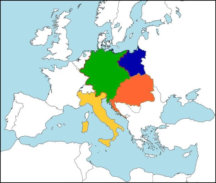
 
I just read your fact-sharing, and I want to thank you. I now feel like an ass for sending links to people if they want to know something. Awesome!
 
Could someone get the colored parts of this version of Europe on a world map around 1914... or at least tell me the way it's done? Except, replace the borders with normal ones(not the big red line and dotty lines)

Spoiler TL1848 :
 
That seems a pretty simple map.. tbh probably best to pick a blank one from the first page and edit in yourself.

That or try and find a 1914 NES
 
Thanks bombshoo. I'm finding the separation of Austria and Hungary on your map to be most useful.
 
Hey wow that central and eastern Europe looks awfully familiar.
 
Hey guys. So, when I get stressed out I tend to indulge in a hobby that doesn't require much thought on my part and for this little episode it was cartography! Here's what I have after half an hour's work sometime yesterday (or today, haven't really slept).


Big Image Warning, 56K'ers beware (and upgrade your damn internet already)
Spoiler :


It's a map for an nes idea I've been tossing around but has taken the backseat for my Geerios NES, though may take the front seat depending upon how Monday goes for me and aforementioned NES.
 
Thanks, but I have no idea how Daft manages to get his terrains to look so realistic- this morning when I woke up I was puzzling over one of his maps before I had to drive my mum to work.
 
Yeah, I just use render clouds from photoshop over and over and over. It works, but it's no satellite imagery.


EDIT:
Results of some more waffling about.

Spoiler :
 
Top Bottom