Greece

MaisseArsouye

gentil petit nuton
Joined
Aug 31, 2003
Messages
1,297
Location
Djiblou
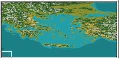
This is a map of Greece, the Aegean sea and eastern Turkey.

hellas_ma.jpg


version 2.0g ( 06/03/2005 ) including
31 civs with starting loc and complete informations ( greek names ) !!!!
( thanks to Varwnos, Mongoloïd Cow and Gagliaudo )

Aetolia
Aiolia
Argos
Athinai
Bithynia
Chalkidike
Chersonesos
Dodekanesa
Elis
Epeiros
Euboia
Illyria
Ionia
Ithake
Karia
Kerkira
Korinthos
Krete
Kyklades
Lokris
Lydia
Makedonia
Messenia
Mycenai
Phokis
Phrygia
Sparte
Thessalia
Thevai
Thrake
Troia

http://www.civfanatics.net/uploads9/Hellas_ma_2g.zip


This map is designed to match my Greek City Graphics Pack.
 
What is your next project going to be?
 
This is a 180X180 map. It's done with bmptobic on the base of a satellite map. I just corrected some stuff to make it as realistic as possible while it's playable.

And this is a clean map : no starting loc, no ressources,...
 
I've been trying to use that bmptobic utility to create my own maps but have no way to convert the palette to the format required by the application. How do you get it to happen?
 
Nanocyborgasm said:
I've been trying to use that bmptobic utility to create my own maps but have no way to convert the palette to the format required by the application. How do you get it to happen?

The bmptobic utility contains two elements :
map.exe the software that make the conversion
bmptobic_palette.bmp the reference palette

Please notice that I use PSP8, I don't know how to do with other softwares. When I began to use bmptobic, I opened bmptobic_palette.bmp and I saved its palette under bmptobic_p

Once I found a good picture as a based for my map, here's the way I proceed from A to Z :
1) Open the picture AND bmptobic_palette.bmp
2) Use the bmptobic_palette colours and PSP8 tools to modify the picture. There's quite no easy way to do it. Even with a very good physical map. This actually IS some work. I have some tips, but I never do twice the same.
3) Once you picture is finished, load the palette_p so that there's no "'wrong" colour
4) Make sure your picture as a size compatible with map.exe, if not, resize it
5) Save it as a bmp file and close PSP8
6) open map.exe and load picture.bmp
7) generate map, verify there's a bmptobic_output.bic in picture.bmp directory, then close map.exe
8) open the editor and, in a new map, IMPORt the map from bmptobic_output.bic
9) make the last corrections with the editor

It's quite impossible to have a good map ONLY with bmptobic. You have to modify some details.
 
Unfortunately, the only graphical editor I have is Paint. Is there any other software that I can download (hopefully free) to accomplish the same thing?

Right now, I'm trying, the hard way, to convert a map of mesoamerica into a standard civ3 map. I can probably finish it but it'll take a long time, this way.
 
Nanocyborgasm said:
Unfortunately, the only graphical editor I have is Paint. Is there any other software that I can download (hopefully free) to accomplish the same thing?

I don't know, sorry.

Nanocyborgasm said:
Right now, I'm trying, the hard way, to convert a map of mesoamerica into a standard civ3 map. I can probably finish it but it'll take a long time, this way.

Why don't you post request for a clean map with only coasts and main features ? You post the picture the morning and, if a map maker has some time, you got it in the afternoon ! I made 2 of these maps yesterday ;) When you have it, you finish the map by adding rivers, details,...that, actually, you can't do with BMPTOBIC.
 
MaisseArsouye said:
This is a 180X180 map. It's done with bmptobic on the base of a satellite map. I just corrected some stuff to make it as realistic as possible while it's playable.

And this is a clean map : no starting loc, no ressources,...
I like it... but is there an chance getting this map in different scale? Something between 100x100 up to 130x130 or 140x140. But not larger.
 
Here's the map I'm trying to convert. It's to be used for a mesoamerican scenario featuring only Maya kingdoms. Obviously, the locations can be ignored. I only need the terrain. See what you can do to convert it to bic or biq format (doesn't matter which to me). Thanks.
 
Back
Top Bottom