hangman
almost-scientist
I've been studying the New World, particularly the Andes when I realized just how complicated and obscurely-sourced it is, for nearly as long as I've been modding. Now what will I do with all this knowledge? I can't use it much in atmospheric science (my chosen field) so instead I'll try to dump as much as I can into easy-to-understand formats.
To start, I made a map of the Pukina language distribution (NOT Uru-Chipaya!) roughly between the Late Intermediate Horizon and the early colonial period. Geography in general is quite painful to work out for the pre-Columbian Americas, since primary sources tend to focus on particular sites. It's been even more excruciating to divine where the Pukina domains were, because they had been largely replaced by Aymara-speaking tribes sometime after the collapse of Tiwanaku, and also because Pukina has been dead for a couple of centuries.
I used The puquina Language in the Early Colonial Southern Andes (1548-1610): A Geographical Analysis (Faura 2014) to determine where the known distribution of Pukina was during the historical era. Next, I used the Pukina dictionary here to find sites where Pukina had an influence. Finally, I mapped ethnicities likely to be Pukina (Chiribaya, Kallawaya, and some less certain ethnicities), as can be seen in Rowe's (1963) map of the LIP Andes and other sources.
So without further ado:
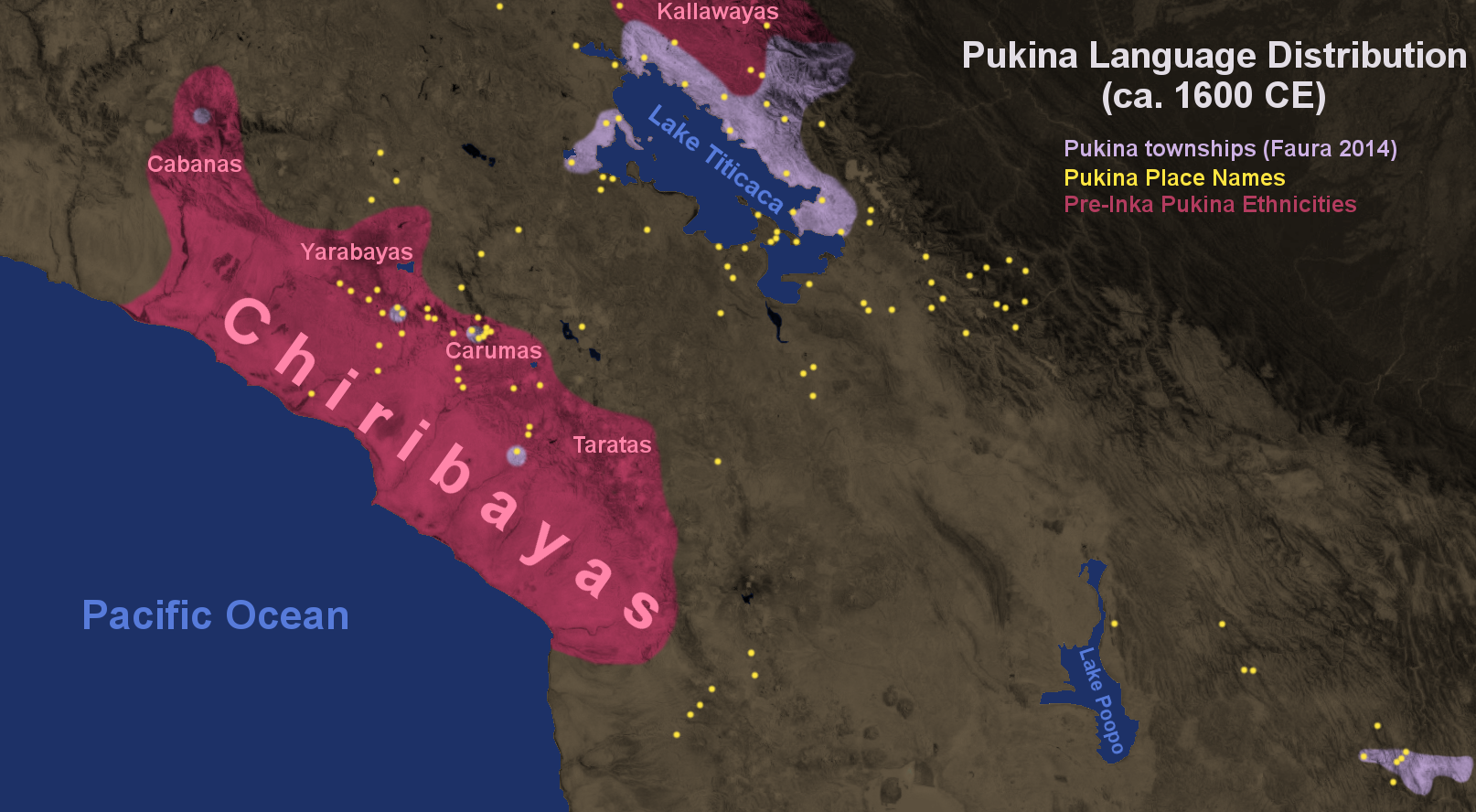
I should note that the errant purple patch near Sucre, Bolivia could possibly also include the Yampara tribe to the east, often considered an Aymara kingdom. There are also a Pukina few place names in that area [off the map to the east]. There are also some unrelated Pukina mitmaq communities in Potosi, Bolivia, but they aren't indigenous to the area.
To start, I made a map of the Pukina language distribution (NOT Uru-Chipaya!) roughly between the Late Intermediate Horizon and the early colonial period. Geography in general is quite painful to work out for the pre-Columbian Americas, since primary sources tend to focus on particular sites. It's been even more excruciating to divine where the Pukina domains were, because they had been largely replaced by Aymara-speaking tribes sometime after the collapse of Tiwanaku, and also because Pukina has been dead for a couple of centuries.
I used The puquina Language in the Early Colonial Southern Andes (1548-1610): A Geographical Analysis (Faura 2014) to determine where the known distribution of Pukina was during the historical era. Next, I used the Pukina dictionary here to find sites where Pukina had an influence. Finally, I mapped ethnicities likely to be Pukina (Chiribaya, Kallawaya, and some less certain ethnicities), as can be seen in Rowe's (1963) map of the LIP Andes and other sources.
So without further ado:
Spoiler :
I should note that the errant purple patch near Sucre, Bolivia could possibly also include the Yampara tribe to the east, often considered an Aymara kingdom. There are also a Pukina few place names in that area [off the map to the east]. There are also some unrelated Pukina mitmaq communities in Potosi, Bolivia, but they aren't indigenous to the area.