Inverted Mediterranean

What do you think?

  • This map idea is original

    Votes: 11 40.7%
  • This map idea is stupid

    Votes: 10 37.0%
  • "You need to explain this more...

    Votes: 10 37.0%
  • ...or maybe I'm just too dull"

    Votes: 4 14.8%

  • Total voters
    27

Crayton

King
Joined
Jul 18, 2004
Messages
698
Location
FLORIDA
No! Land and Sea have not been switched. The globe has been punched through the Mediterranean!

I've been wanting to play on a real-world map that has x and y wrapping. I think there is a way. The only problem is I am not the best map maker. I'd like some suggestions on this map; but, more preferably, someone to take this idea and run with it. No need to credit me with anything, as long as the map is complete.

Oh ya. What's the map? The Mediterranean occupies the outer edge of the map and the world fits inside at an ever-decreasing scale until it reaches America. I've made a 30 x 30 map and attatched a pic. If anybody can make this 100 x 100, with a more diverse landscape, PLEASE!

Thanks.

The map is .txt, download it into your scenario folder and open it with the Conquests' Editor.
No unzipping!
 

Attachments

  • Med2.bmp
    486.4 KB · Views: 1,408
  • Inverted.txt
    2.8 KB · Views: 259
The top left is Africa, the bottom left is Europe and the right is Asia. I added cities and names so that you can get a feel for what is represented. Sadly, the pic is of poor quality.

Here is a zoomed in portion of Africa. Again, not much can fit on a 30 x 30 map so I'm looking for interest in the idea and in building a bigger map.

Wow! It actually shows now!
 

Attachments

  • Med.bmp
    491 KB · Views: 1,667
Oops. Now I don't understand yours. The objective is to fill all but the edges of the map with land (the edges simulate the Mediterranean). The inland sea is the Atlantic/Pacific/Arctic/Indian Oceans. Put some cities on the map to help us out.

Maybe this idea is TOO confusing.

More help and suggestions are encouraged.
 
Here you go
 

Attachments

  • insideout.JPG
    insideout.JPG
    5.8 KB · Views: 1,721
Oh I see. Yours and mine are just reversed clockwise/counter-clockwise. That's pretty good. If you could get the strait of Gibralter in there and put the edges as close as you can to the land it would be perfect. Thanks for taking the time!
Is the purple Arabia or India?
 
I originally tried making anormal Mediterranean map, failed, and sought other people's maps. The problems were that either the map was mostly a big sea (ironic isn't it) or that the major land masses were the Balkans, Anatolia, North Africa, and Spain; because all of the minor seas pushed the map's scope further out: like the Tyrhennian, Aegean, Lybian, and Levantine.

Maybe I should make a map with features squished into the sea, thereby making the sea more like a snaking-lake. Obviously I prefer this 'Inverted Mediterranean' more. I just wish it was easier to get my mind around (how does it work again?).
 
I dont have acces to civ edit right now but when i do i will strtche africa to be more size equivelent an alos make an asia and western hemisphere in the center

I have added a terrain type veriations too. Do you want me to put in antartica caouse i might not have room
 
I don't know how much you can fit as you get further from the Mediterranean. Just the Old World would be nice with a little bit in the middle of the World's Oceans just so it's not feature less; maybe enough for three cities on th Americas. Britain will need to be in there too. Take your time in getting the Editor back up, I'm very pleased someone with skill is taking the time.

Anyone else who is interested, or maybe thinks that they can do a better/faster job: start your map-making!
 
thanx but i dont have that much skill

actually i am glad that the first real world map i am making dosnt have to be to scale

on the current version there is like 6 or seven tiles in america and england is connected to france it is the orange bove the pink in my map
 
I went through and tried to increase the size of africas mediterainian cost but it ends up looking realy bad so it might need to stay how it is
 
the as of now finished product

complete with start locations
No resources
 

Attachments

  • insideout.zip
    8.7 KB · Views: 160
@ I am the future

Try putting the Mediterranian in the center and the oceans on the outside then you could fit the Americas and Australia. :)
 
Do you mean like a polar projection of the Mediterranean?
This would be cool, but I was looking for quite the opposite: The Mediterranean on the edges and the continents in the interior.
 
actualy america is there the only excluded coninents are australia and antartica
 
I know that y'all putt the Mediterranian on the out sides of your maps, but it just seems like IMHO that everything would fit much better with the Mediterranian in the middle, don't you think? :)
 
Crayton: Although I can still continue on with this map if you want, you've just given me the most AWESOME of ideas which I reckon would be EVEN BETTER than this one!!! :D Read on, and tell me if you think it's worth swapping projects.

Basically, this is it: You were sort of on the right track with this 'Inverted Mediterranian' map thing... but your idea is quite (okay, very) complex, and there's a FAR better (and more simple!!!) solution that you've overlooked! (Don't worry, it took me this long to think of it myself, even though it's so damn obvious!!! :lol: ) It's incredibly, blatantly, stupidly obvious once you read it... scroll down to see!!! :D

..............


...............Use the same idea, but with respect to the Earth's Poles!!! Basically, this would mean that the centre tile of the map is the North (or South) pole, and all four edges of the map are the opposite pole. This WOULD WORK for allowing BOTH X and Y wrapping on a world map... and yet having it MAKE SENSE as a recognisable world map!!! :cool:

I found a couple of pictures to show what I mean... they're not very good (obviously I would expand them out to cover the whole world - I just couldn't find any maps on a quick search that showed the whole world in this form), but hopefully you'll get the idea from them. Isn't it obvious? :D :duh: <- (now there's an emoticon we need here ;) )

What do you (and everyone else) reckon? If you think it's a good idea, I'd be happy to do at least two maps of this form (both 100x100 [Standard], one centred on the North Pole and the other centred on the South Pole)... and possibly, if there's enough demand, I'd do four maps (160x160 [Huge] - or maybe larger [if the people here can convince me ;) ] - versions of both maps). :D

@Crayton: If you want, of course, I can still continue on with the 'Inverted Mediterranian' map... but I think this proposed project might be of much more interest to you. :)
 

Attachments

  • world north pole.gif
    world north pole.gif
    76.7 KB · Views: 217
  • world south pole.gif
    world south pole.gif
    78.6 KB · Views: 179
@ Lord Parkin

Great idea, I like it. :goodjob:
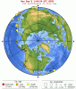
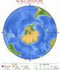
This works better cause you should center large areas around smaller points instead of the opposite, kind of like i proposed putting the Mediterranian in the center but the north pole is even smaller so that should work better. :)
 
Mmm, and either way you'd have ocean all around the edges, like Crayton wanted originally... for the map centred on the South Pole, the edges would all be the North Pole, which is water (obviously ;) )... and for the map centring on the North Pole, I think I'd delete Antarctica from the map completely (it'd look REALLY weird anyway, stretching around the entire border of the map!!! :crazyeye: :eek: ) - so that'd also mean that the edges of the map would be water. :)

Obviously there's no way you can perfectly get a sphere onto a 2D map (actually, you can't even get close)... so the map would look a little bit stretched near the borders (ie in the South Pole centred map, Canada, Alaska, Russia, and Europe would all be huge - stretched around close to the borders of the map. And in the North Pole centred map, countries like Australia and New Zealand would be quite large while Canada, Alaska, Russia, and Europe would all be tiny - curled around the centre of the map. But that can't be avoided; and anyway, I don't think it really matters much ;) ).

The way I am thinking of doing this is to have the latitude (N/S) of the map evenly spaced, in concentric circles around the centre of the map (think of it like this: one circle, say of radius 5 tiles, would be at 10 degrees latitude, the next circle of radius 10 tiles at 20 degrees latitude, and so on. Not sure if that's the easiest way of explaining it... but just trust me, it'll work ;) ). Of course, longtitude (E/W) will get [insanely!] stretched, especially towards the borders of the map, by this method... but I think that despite this shortfall, it's the best way to do a map like this. ;)
 
Top Bottom