You could make a bridge graphic that replaces the fortress or barricade, for instance, of a bridge with a river under it.
Or put the bridge graphic directly onto the river file, but then every time a river bent left, for instance, a bridge would be there.
Another way to think about this problem, though, is to think about the terrain as layers that go overtop one another. We know, for instance, that forests cover grassland, rivers cover forests, cities cover everything. (You could actually make a chart of this, noting the layer of every graphic, if you have more time than I do.)
The basic size of a grid square is 64 x 64. The basic size of a resource square is 49 x 49 centered in a grid square - not useful for bridge making unless you do as I did with the rope bridge, and pick a watery spot where the land graphics come very close together.
Some of the graphics use larger basic graphics squares; the forests and roads, for instance, are on 128 x 64 pixel squares. The roads are a bad bet for our purpose, because they're
always covered by rivers. Bad choice by the programmer, who should have included a line of code that reversed this when an "allows bridges" tech was discovered.
On the other hand, forests, marshes, mountains, and hills use a larger grid, and, when placed
next to (in front of) a river tile, will cover the river; that's what we're looking for.
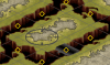
So I took a graphic I wasn't using in the Lost Worlds Mod (I left a graphic
unused??) - the Mountains-snow graphic - made a transparent layer, and put a bridge across the 64 x 64 diamond on the first graphic, which appears when a single snowy mountain is place next to a river, then filled the rest with transparent-magneta, deleted the original image and saved.
The result looks like this:
Here's the file (remove the word BRIDGE to use):
View attachment BRIDGEMountains-snow.pcx
The downside of course, is that the snow-mountains have exactly the same settings as regular mountains, so unless you change the setting on all of your mountains, this will have limited application. You can use whichever oversized graphic you want, though, so if you're willing to sacrifice a square next to every river, you could get away with it. Don't forget that the game always uses LMGrassland underneath mountains and hills.
I also discovered the other night that the Victory Point graphic can be resized to
any size, so could be used to create a bridge graphic, too. Since it would be a regular-sized graphic offset, it won't likely cause the problems that graphics that have been resized much larger often have, i.e., they don't appear unless the
entire graphic is in the frame. An interesting use, though, would be to use such a technique to make bridges across the Rhine in a WW2 scenario.
No matter which technique you use, the bridge probably has to go in only one direction, like these.
Finally, there's the land bridge. If you use Coast terrain to make very, very fat rivers, you can redo the graphics of your terrain files to make land bridges. I made a mini tutorial for that >
here<. King Arthur, in his Super Scenario, has combined terrain-bridges with terrain-roads to great effect. Here's a pic of an experiment I've been doing lately with it, making streetlights with irrigation...
Sorry to be so wordy, but, as you might have guessed, this is something I've put some thought into.


") I love that streetlight-irrigation idea.
I love that streetlight-irrigation idea.