Calradia Map HELP

tedros91

Chieftain
Joined
Oct 15, 2009
Messages
34
Location
Brooklyn, New York
Hi, everyone.

I'm thinking of doing a mod for Calradia (the world of Mount and Blade), however I am not very good at making maps. I need aid in the making of said map. I already have an idea of factions (with their peculiarities) and also a tech trees. Hence if someone could help out that would be awesome.

So the factions are thus:

The Kingdom of Swadia (Industrious & Militaristic), basically inspired by the Holy Roman Empire. There is an emphasis on their knights being the key to military dominance and formidable infantry units.

The Rhodok Republic (Commercial & Scientific), former subjects of the Swadians inspired by the Italian city states. Their bread and butter are their crossbows and pikemen. Great on the defense especially in hilly and mountainous terrain but needs a tactical edge for any expansion of territories.

The Khergit Khanate (Militaristic & Expansionist), essentially the Mongols/Tatars. Hit-and-Run horse archer cavalry however they would have cheap and somewhat weaker infantry.

The Grand Principality of Vaegirs (Agricultural & Commercial), inspired by the Kievan Rus. They have formidable cavalry and very formidable infantry units, especially in the later ages.

The Sarranid Sultanate (Industrious & Religious), inspired by the Turko-Persian dynasties of India, Iran and Iraq. Overall they have a balanced army but have a distinct advantage in desert terrain.

The Kingdom Nords (Seafaring & Militaristic), inspired by Viking/Scandinavian culture. They excel in melee infantry and naval warfare (with amphibious units) but hardly any cavalry.

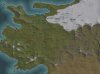
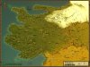
The Map looks likes this:


What do you guys think?
 

Attachments

  • WarbandWorldMap.jpg
    WarbandWorldMap.jpg
    394.9 KB · Views: 498
  • Map_of_Calradia.jpg
    Map_of_Calradia.jpg
    530.3 KB · Views: 1,105
It sounds quite interesting. Are you looking for someone to do the map for you, or just help out? Also, have you given any idea as to how large you would like the map to be?
 
I would prefer if someone else made it, I was never good with map making. On the map size, I am thinking a large map. I'm not sure on the specific dimensions however I would prefer on a scale similar to the maps for the MEM mod.
 
So, 180x180? How soon are you looking to have this done? Would a bare map (meaning terrain only, no goods or cities) be ideal for you?
 
I'm thinking of doing a mod for Calradia (the world of Mount and Blade), however I am not very good at making maps. I need aid in the making of said map. ... Hence if someone could help out that would be awesome. ... What do you guys think?
It is very important to be clear about the level of help you are asking from a map maker. There's a huge difference in time commitment between making a map that is just geography & working with you to place resources, cities, etc.

I would prefer if someone else made it, I was never good with map making. On the map size, I am thinking a large map. I'm not sure on the specific dimensions however I would prefer on a scale similar to the maps for the MEM mod.
Those vary a lot in size.

So, 180x180? How soon are you looking to have this done? Would a bare map (meaning terrain only, no goods or cities) be ideal for you?
The size Gojira mentions is that of Yoda Power's large MEM Europe map. The questions he asked are the fundamental ones I already mentioned. It's important also for a potential map maker to know how comfortable you are with editing details yourself (shifting mountains, adding rivers, etc.) once the basic map is in hand.

Another question is whether you want a map just of a section of continent (top image) mean the map doesn't wrap, or of the whole world (bottom image) that does wrap. If the latter you will need to sketch out a lot of info for the map maker to base a design on.


If all you want is a bare map you are more likely to get help than if you are looking for a "full-time" partner who isn't already interested in the kind of scenario you are designing. OTOH if you are prepared to do the majority of work editing the map beyond laying out the geography, you will get a lot of support from a lot of people in terms of answering specific questions on the main C&C forum once you have a basic map.
 
I second Blue Monkeys emotion.

If you are looking for a geographical map of the top image, I can do that for you, provided you are flexible with time. Beyond that I can promise nothing, but am happy to do that for you. I do enjoy map-making.

If I were to do it, it would include the terrain (In this case Grasslands in the west, tundra in the northeast, desert in the southeast, plans in the middle, forests, hills, and mountains, as well as the aquatic terrains and rivers. Jungles, marshes, and volcanoes I do not see on the map, so once I get the rest done, you can tell me where or if you want any of those. I would make the terrain changes gradual, rather than abrupt - meaning tundra would become less frequent and grassland more, as you travel southwest from the northeast corner, rather than pure tundra then pure grassland. I would submit to you and tweak as you prefer until you are happy with it.

We can also do odd sized maps, like 208 x 162, since the map image is not perfectly square. All your call.
 
Gojira & I are on the same page.

Looking at some of the larger images I found online, there are indicators for forests, but not for the other terrains, as he pointed out. For playability it is important not to have too large of swathes of identical terrain. In addition to the gradual transitions it's a good idea to have small patches of other terrains - hills or plains within deserts, small lakes in the middle of the grassland, etc.

I'd also be interested in making a map. Got the feeling Gojira has way more available time for outside projects than I do atm, so he could probably do more of the detailed adjustments than I would be able to.
 
Assuming I have more available time may not be wise, but then again I've no clue what your schedule is like. :)

I wouldn't be opposed at all to some sort of collaborative effort...
 
It is very important to be clear about the level of help you are asking from a map maker. There's a huge difference in time commitment between making a map that is just geography & working with you to place resources, cities, etc.

Those vary a lot in size.

The size Gojira mentions is that of Yoda Power's large MEM Europe map. The questions he asked are the fundamental ones I already mentioned. It's important also for a potential map maker to know how comfortable you are with editing details yourself (shifting mountains, adding rivers, etc.) once the basic map is in hand.

Another question is whether you want a map just of a section of continent (top image) mean the map doesn't wrap, or of the whole world (bottom image) that does wrap. If the latter you will need to sketch out a lot of info for the map maker to base a design on.


If all you want is a bare map you are more likely to get help than if you are looking for a "full-time" partner who isn't already interested in the kind of scenario you are designing. OTOH if you are prepared to do the majority of work editing the map beyond laying out the geography, you will get a lot of support from a lot of people in terms of answering specific questions on the main C&C forum once you have a basic map.

A terrain map of the top image (focused on Calradia) is exactly what I'm looking for, the dimensions well I'm not too specific but it has to be large but at the same the creator can take liberties with that detail. As for terrain, the basic terrain should match the given map as much as possible. A bare map is also preferable since I am still figuring out what resources should be included.
 
Here is a very quick test run using the bmp import function in Quintillus' editor.


The test was strictly for looking at size & coastline.

  • Horizontally it's 180 tiles. Vertically it's 274 - that's really only 137 in actual height since C3 counts the tiles vertically in a zigzag.
  • Where the water is the narrowest on the Western edge of the map it's about 4 tiles wide. It's simple to add more water tiles to the edge if you want a wider passage.
  • I'm inclined to move the cluster of 3 islands in the Southwest a tile or two further from the mainland. If you would like smaller islands anywhere on the map, give me a rough idea where.
  • By the looks of the source map there should be a long narrow inlet in the Northern bay. Right now there's only a slender notch, but that can be extended quite easily in the next pass of mapwork.
  • One thing missing from the source map are lakes (apart from the two oases in the desert). Would you like any? If so, roughly where?
  • spreading from coastal waters to deep ocean - should there be a lot of shallow water or a more rapid drop off? Doesn't need to be the same everywhere & just a rough description of how you want it is fine.

Once you have a chance to comment in general on the size & coastline I can do a next pass with some very basic blocky terrain. That should then only take a day or 2 before you would see the next wip.

You my friend are an artist. I like what I see so far, the dimensions look good and the coastlines look good. As for the coastal waters I would prefer a rapid drop off once one goes beyond the coast. As for lakes I'm not exactly sure, but most of the lakes I'm thinking should to the north and the west, since the southern parts of the map are deserts and the east is steppe land. However I trust fully in your judgement on where the lakes should be as long as the rivers are positioned according to the source material. Either way so far, so good I'm loving what I'm seeing.
 
I like what I see so far, the dimensions look good and the coastlines look good. As for the coastal waters I would prefer a rapid drop off once one goes beyond the coast.
Simple enough. I'll put a little bit of variation - more for aesthetics than anything - but keep it as you suggest. You didn't mention anything about extending the map to have more water to the West of the Rhodok Highland so I'll leave it as is for now. Quick enough to easily change later.

As for lakes I'm not exactly sure, but most of the lakes I'm thinking should to the north and the west, since the southern parts of the map are deserts and the east is steppe land. However I trust fully in your judgement on where the lakes should be ...
Probably better to wait & see how things work in the biq as you add resources & think about gameplay then. For this next pass I'll limit it to a couple of single-tile lakes as markers where the map has the oases. You can easily replace them with a resource on desert or use the trick of placing floodplains without a river. The actual floodplains graphic only appears along rivers - floodplains tiles use the desert graphic as a base but have separate values in the editor. This can be especially handy if you want to keep the oases hidden at the beginning of the game. It also limits the spread of irrigation since rivers are the water source, not floodplains.

... as long as the rivers are positioned according to the source material.
I'll place the four rivers shown on the map & leave anything else til later.


There are little to no hills marked on the map. C3 has no separate "escarpment" or "cliff" terrain. I'll use those as indicators for where to place hills - they seem to be consistently in places where hills would make sense for gameplay reasons anyway.


Is the area in the center of the image meant to be an island? Or is that just the river splitting into two deltas?


Either way so far, so good I'm loving what I'm seeing.
You my friend are an artist.

The utility made by Quintillus really makes the process simple for anyone who can use layers in Photoshop, GIMP, etc. & who understands palettes enough to index an image. The source map is clear enough that really I'm only doing "paint by numbers".
I will drink from your skull approve of this effort.
 
There are little to no hills marked on the map. C3 has no separate "escarpment" or "cliff" terrain. I'll use those as indicators for where to place hills - they seem to be consistently in places where hills would make sense for gameplay reasons anyway.

This was EXACTLY what I was planning to do. Good to see we think alike.

I will leave this fun little project in your more-than-capable hands :)
 
This was EXACTLY what I was planning to do. Good to see we think alike.

I will leave this fun little project in your more-than-capable hands :)
It's a relaxing break from other projects & easy to do during times when I want to avoid prep for the holidays. Don't have to rack my brains remembering where I left off.

I do expect - indeed depend on - your frank critique throughout the process, along with the same from the other map makers who've shown us the way.
 
Simple enough. I'll put a little bit of variation - more for aesthetics than anything - but keep it as you suggest. You didn't mention anything about extending the map to have more water to the West of the Rhodok Highland so I'll leave it as is for now. Quick enough to easily change later.

Probably better to wait & see how things work in the biq as you add resources & think about gameplay then. For this next pass I'll limit it to a couple of single-tile lakes as markers where the map has the oases. You can easily replace them with a resource on desert or use the trick of placing floodplains without a river. The actual floodplains graphic only appears along rivers - floodplains tiles use the desert graphic as a base but have separate values in the editor. This can be especially handy if you want to keep the oases hidden at the beginning of the game. It also limits the spread of irrigation since rivers are the water source, not floodplains.

I'll place the four rivers shown on the map & leave anything else til later.


There are little to no hills marked on the map. C3 has no separate "escarpment" or "cliff" terrain. I'll use those as indicators for where to place hills - they seem to be consistently in places where hills would make sense for gameplay reasons anyway.


Is the area in the center of the image meant to be an island? Or is that just the river splitting into two deltas?


The utility made by Quintillus really makes the process simple for anyone who can use layers in Photoshop, GIMP, etc. & who understands palettes enough to index an image. The source map is clear enough that really I'm only doing "paint by numbers".


Looking at the Sargoth's location it's a delta. I think it could be alright to have flood plains near Shariz and maybe a small lake near Tulga. I like how you are going about this mate, I really can't wait to see the map. Once the map's ready I'll start making the mod/scenario, it will be EPIC.
 
Which version of Quintillus' editor has the BMP import function available?

Correction: I have the import in the 0.98 Version, so disregard the question.
 
Top Bottom