Back in 2014 or 2015, I added a feature to my editor that allowed creating a map from a BMP image. It wasn't the first time that had been done, but it allowed arbitrary map sizes, and allowed more colors than a 1:1 ratio to terrains, and was thus more flexible than previous options.
Arbitrary map sizes... limited only by Civ3's well-known tile limit, of... 362x362 tiles? Not so! There is a Civ3 limit, but the limit is 65,535 tiles, or 2^16 - 1, and 362 is simply the largest number you can fit into a square Civ3 map (or square in an isometric sense, at least), and so that was the limit that the Firaxis editor made, and to my knowledge there hasn't been a map with more than 362 tiles in a single dimension to date.
After adding that feature, I used it to create an Earth map, using NASA satellite imagery of the Earth, in equirectangular projection, as a source, producing satisfactory contours of the landmasses, and halfway decent forest coverage, albeit with some forest/jungle confusion. However, many finer details would be needed to turn it into a fully playable Earth map - notably, hills, mountains, rivers, and resources, in addition to some fine tuning here and there. Alas, it turns out I am not a natural map maker, and it's now been close to 4 and a half years since I last updated the map.
Thus I've decided to upload the work-in-progress of it, so that if anyone would like to take up the torch, they are able to, as well as for the possibility that having more community input from it may motivate me to move it forward at least somewhat.
My overall vision for it comprises (in no particular order):
- Encouraging thinking outside the box with map dimensions
- A more realistic, aspect-ratio-wise, Earth map of the larger possible dimensions
- Due to the inherent Civ3 city number limitations, I'd imagine limiting cities by some combination of not being able to build on desert/tundra, perhaps as well as limiting city building to certain spots (e.g. marsh, hills).
- Lately I've been thinking of a world-wide scenario that pushes Civ in some ways that I still need to prove are technically feasible. Yes, it would work just fine on Marla Singer, Yoda Power, or Rhye's maps, but more tiles and detail are always tempting.
Map details:
- Equirectangular
- 75 degrees North to 60 degrees South
- Beyond the map projection, no continents are favored
- Australia is larger than Greenland
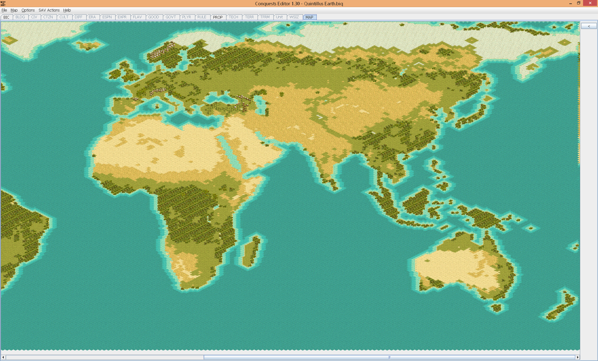
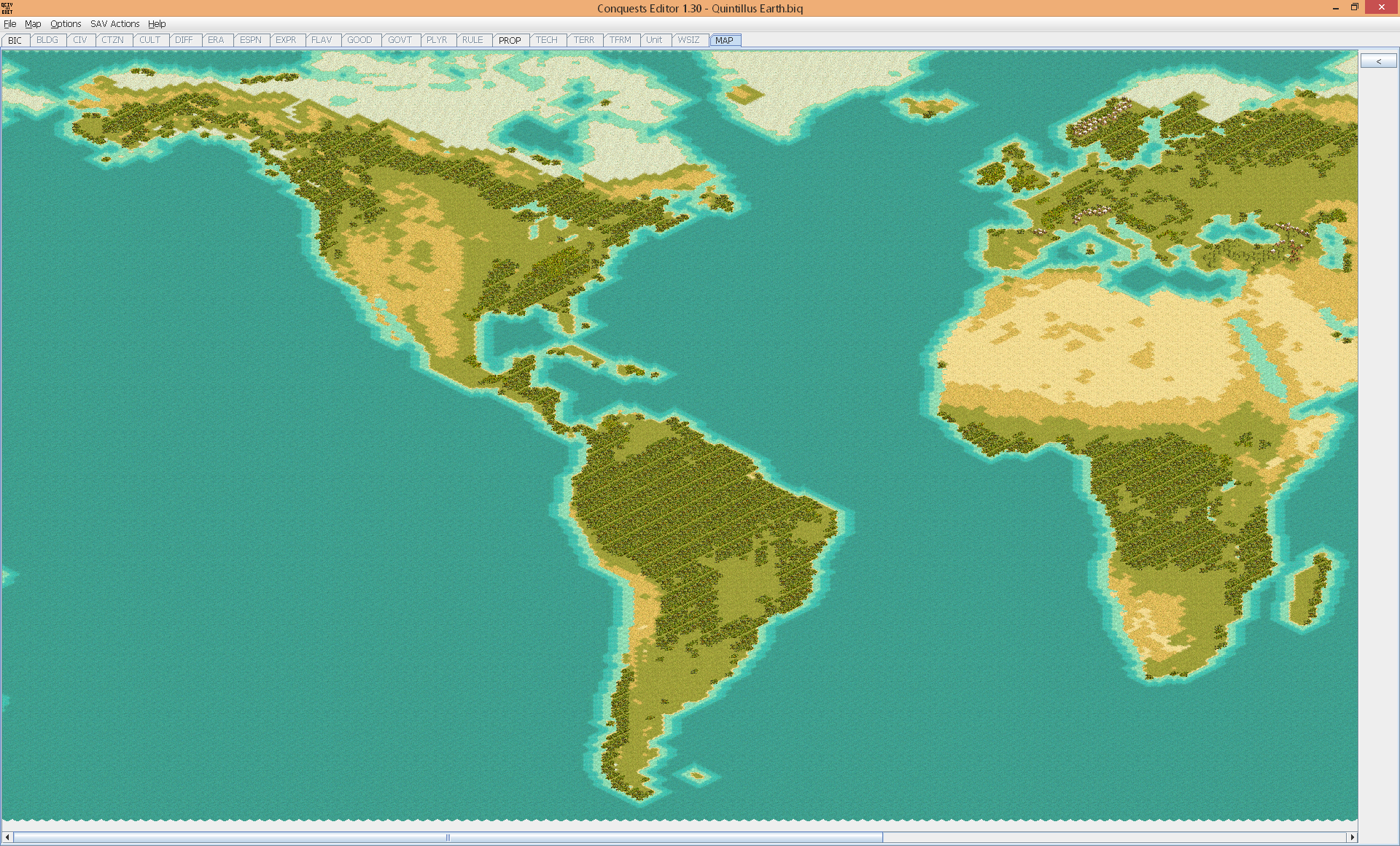
Screenshots (at 10.6% zoom; 1920x1160):
BIQ Download (Firefox/IE only; does not work in Chrome or derivatives (See also attachment for .zip version)
I'll probably add it to the downloads database once it's more polished.
Arbitrary map sizes... limited only by Civ3's well-known tile limit, of... 362x362 tiles? Not so! There is a Civ3 limit, but the limit is 65,535 tiles, or 2^16 - 1, and 362 is simply the largest number you can fit into a square Civ3 map (or square in an isometric sense, at least), and so that was the limit that the Firaxis editor made, and to my knowledge there hasn't been a map with more than 362 tiles in a single dimension to date.
After adding that feature, I used it to create an Earth map, using NASA satellite imagery of the Earth, in equirectangular projection, as a source, producing satisfactory contours of the landmasses, and halfway decent forest coverage, albeit with some forest/jungle confusion. However, many finer details would be needed to turn it into a fully playable Earth map - notably, hills, mountains, rivers, and resources, in addition to some fine tuning here and there. Alas, it turns out I am not a natural map maker, and it's now been close to 4 and a half years since I last updated the map.
Thus I've decided to upload the work-in-progress of it, so that if anyone would like to take up the torch, they are able to, as well as for the possibility that having more community input from it may motivate me to move it forward at least somewhat.
My overall vision for it comprises (in no particular order):
- Encouraging thinking outside the box with map dimensions
- A more realistic, aspect-ratio-wise, Earth map of the larger possible dimensions
- Due to the inherent Civ3 city number limitations, I'd imagine limiting cities by some combination of not being able to build on desert/tundra, perhaps as well as limiting city building to certain spots (e.g. marsh, hills).
- Lately I've been thinking of a world-wide scenario that pushes Civ in some ways that I still need to prove are technically feasible. Yes, it would work just fine on Marla Singer, Yoda Power, or Rhye's maps, but more tiles and detail are always tempting.
Map details:
- Equirectangular
- 75 degrees North to 60 degrees South
- Beyond the map projection, no continents are favored
- Australia is larger than Greenland
Screenshots (at 10.6% zoom; 1920x1160):
Spoiler Old World :
Spoiler New World :
BIQ Download (Firefox/IE only; does not work in Chrome or derivatives (See also attachment for .zip version)
I'll probably add it to the downloads database once it's more polished.
Attachments
Last edited:

")
 " (TM) not only because I have difficulty using gfx tools, but because I don't "think" visually. (True story: 6 years after I moved into my girlfriend's apartment, we were having a dinner party during which one guest mentioned the exposed brick wall in the bedroom. Startled, I replied, "There's a brick wall in the bedroom?") It would have been much easier for completely "see" your point without the numbered tags "confusing" me.
 I'm doing a similar map for Terra Fantasia. The Earth looked different 120,000 years ago, but the overall shapes of the continents were the same ...

 Although, cutting off a coastal trade route could force civs into building a land route over the Sahara. Get yourself some Tuareg caravans that can handle the higher movement cost you put on desert.